Port-Mort
| Port-Mort | ||
|---|---|---|
|
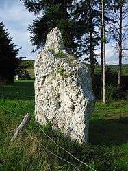
Menhir | ||
| ||
 Port-Mort | ||
|
Location within Normandy region  Port-Mort | ||
| Coordinates: 49°09′55″N 1°24′57″E / 49.1653°N 1.4158°ECoordinates: 49°09′55″N 1°24′57″E / 49.1653°N 1.4158°E | ||
| Country | France | |
| Region | Normandy | |
| Department | Eure | |
| Arrondissement | Les Andelys | |
| Canton | Les Andelys | |
| Intercommunality | Les Andelys et ses Environs | |
| Government | ||
| • Mayor (2008–2014) | Guillemette Alquier | |
| Area1 | 12.17 km2 (4.70 sq mi) | |
| Population (2008)2 | 1,009 | |
| • Density | 83/km2 (210/sq mi) | |
| Time zone | CET (UTC+1) | |
| • Summer (DST) | CEST (UTC+2) | |
| INSEE/Postal code | 27473 / 27940 | |
| Elevation |
8–138 m (26–453 ft) (avg. 32 m or 105 ft) | |
|
1 French Land Register data, which excludes lakes, ponds, glaciers > 1 km² (0.386 sq mi or 247 acres) and river estuaries. 2 Population without double counting: residents of multiple communes (e.g., students and military personnel) only counted once. | ||

Port-Mort is a commune in the Eure department in Haute-Normandie in northern France.
Population
| Historical population | ||
|---|---|---|
| Year | Pop. | ±% |
| 1962 | 421 | — |
| 1968 | 431 | +2.4% |
| 1975 | 563 | +30.6% |
| 1982 | 672 | +19.4% |
| 1990 | 839 | +24.9% |
| 1999 | 820 | −2.3% |
| 2008 | 1,009 | +23.0% |
See also
References
External links
| Wikimedia Commons has media related to Port-Mort. |
This article is issued from Wikipedia - version of the 3/15/2016. The text is available under the Creative Commons Attribution/Share Alike but additional terms may apply for the media files.