Humphreys County, Mississippi
| Humphreys County, Mississippi | |
|---|---|
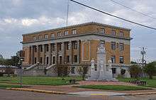 Humphreys County Courthouse | |
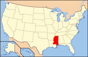
 Location in the U.S. state of Mississippi | |
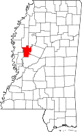
 Mississippi's location in the U.S. | |
| Founded | 1918 |
| Named for | Benjamin G. Humphreys |
| Seat | Belzoni |
| Largest city | Belzoni |
| Area | |
| • Total | 431 sq mi (1,116 km2) |
| • Land | 418 sq mi (1,083 km2) |
| • Water | 13 sq mi (34 km2), 3.0% |
| Population | |
| • (2010) | 9,375 |
| • Density | 22/sq mi (8/km²) |
| Congressional district | 2nd |
| Time zone | Central: UTC-6/-5 |
Humphreys County is a county located in the U.S. state of Mississippi. As of the 2010 census, the population was 9,375.[1] Its county seat is Belzoni.[2] The county is named for Benjamin G. Humphreys. Humphreys County is Mississippi's newest county, having been formed in 1918. Humphreys County is located in the Mississippi Delta region.
It was named 'Farm-Raised Catfish Capital of the World' in 1976 by then Governor Cliff Finch, since it produced more farm-raised catfish than any other U.S. county. Forty thousand acres (160 square kilometers) of the county are underwater and used to grow catfish. About 60% of U.S. farm-raised catfish is raised within a 65-mile (105 km) radius of the county seat, Belzoni. The title "Catfish Capital" has also been claimed by Savannah, Tennessee, and Des Allemands, Louisiana.
Geography
According to the U.S. Census Bureau, the county has a total area of 431 square miles (1,120 km2), of which 418 sq mi (1,080 km2) is land and 13 sq mi (34 km2) (3.0%) is water.[3]
Major highways
 U.S. Highway 49W
 Mississippi Highway 7
 Mississippi Highway 12
 Mississippi Highway 14
 Mississippi Highway 16
Adjacent counties
- Sunflower County (north)
- Leflore County (northeast)
- Holmes County (east)
- Yazoo County (south)
- Sharkey County (southwest)
- Washington County (west)
National protected area
Demographics
| Historical population | |||
|---|---|---|---|
| Census | Pop. | %± | |
| 1920 | 19,192 | — | |
| 1930 | 24,729 | 28.9% | |
| 1940 | 26,257 | 6.2% | |
| 1950 | 23,115 | −12.0% | |
| 1960 | 19,093 | −17.4% | |
| 1970 | 14,601 | −23.5% | |
| 1980 | 13,931 | −4.6% | |
| 1990 | 12,134 | −12.9% | |
| 2000 | 11,206 | −7.6% | |
| 2010 | 9,375 | −16.3% | |
| Est. 2015 | 8,669 | [4] | −7.5% |
| U.S. Decennial Census[5] 1790–1960[6] 1900–1990[7] 1990–2000[8] 2010–2013[1] | |||
As of the 2010 United States Census, there were 9,375 people residing in the county: 74.5% were Black or African American, 23.5% White, 0.2% Asian, 0.1% Native American, 0.9% of some other race and 0.7% of two or more races, and 2.2% were Hispanic or Latino (of any race).
At the 2000 census,[9] there were 11,206 people, 3,765 households and 2,695 families residing in the county. The population density was 27 per square mile (10/km²). There were 4,138 housing units at an average density of 10 per square mile (4/km²). The racial makeup of the county was 27.17% White, 71.51% Black or African American, 0.10% Native American, 0.27% Asian, 0.64% from other races, and 0.31% from two or more races. 1.50% of the population were Hispanic or Latino of any race.
There were 3,765 households of which 36.60% had children under the age of 18 living with them, 38.30% were married couples living together, 27.70% had a female householder with no husband present, and 28.40% were non-families. Of all households, 24.90% were made up of individuals and 10.90% had someone living alone who was 65 years of age or older. The average household size was 2.95 and the average family size was 3.54.
Age distribution was 32.70% under the age of 18, 10.70% from 18 to 24, 25.80% from 25 to 44, 18.80% from 45 to 64, and 12.00% who were 65 years of age or older. The median age was 30 years. For every 100 females there were 87.50 males. For every 100 females age 18 and over, there were 78.70 males.
The median household income was $20,566, and the median family income was $23,719. Males had a median income of $24,948 versus $19,201 for females. The per capita income for the county was $10,926. About 32.40% of families and 38.20% of the population were below the poverty line, including 50.30% of those under age 18 and 31.00% of those age 65 or over.
Humphreys County has the seventh-lowest per capita income in Mississippi and the 56th-lowest in the United States.
Politics
Like most counties in the Delta, Humphreys County is solid democratic. A republican has not won the county since 1972.
Media
The Enterprise-Tocsin, a newspaper based in Indianola in Sunflower County, is distributed in portions of northern Humphreys County.[10]
Communities
City
- Belzoni (county seat)
Towns
Unincorporated communities
See also
External links
References
- 1 2 "State & County QuickFacts". United States Census Bureau. Retrieved September 3, 2013.
- ↑ "Find a County". National Association of Counties. Archived from the original on May 31, 2011. Retrieved 2011-06-07.
- ↑ "2010 Census Gazetteer Files". United States Census Bureau. August 22, 2012. Retrieved November 4, 2014.
- ↑ "County Totals Dataset: Population, Population Change and Estimated Components of Population Change: April 1, 2010 to July 1, 2015". Retrieved July 2, 2016.
- ↑ "U.S. Decennial Census". United States Census Bureau. Archived from the original on May 11, 2015. Retrieved November 4, 2014.
- ↑ "Historical Census Browser". University of Virginia Library. Retrieved November 4, 2014.
- ↑ "Population of Counties by Decennial Census: 1900 to 1990". United States Census Bureau. Retrieved November 4, 2014.
- ↑ "Census 2000 PHC-T-4. Ranking Tables for Counties: 1990 and 2000" (PDF). United States Census Bureau. Retrieved November 4, 2014.
- ↑ "American FactFinder". United States Census Bureau. Archived from the original on September 11, 2013. Retrieved 2008-01-31.
- ↑ "about us." The Enterprise-Tocsin. Retrieved on March 4, 2011. "Our office is located at 114 Main St, Indianola."
 |
Sunflower County | Leflore County | | |
| Washington County | |
Holmes County | ||
| ||||
| | ||||
| Sharkey County | Yazoo County |
Municipalities and communities of Humphreys County, Mississippi, United States | ||
|---|---|---|
| Cities | | |
| Towns | ||
| Unincorporated communities | ||
.svg.png)
Coordinates: 33°08′N 90°31′W / 33.13°N 90.52°W