National Register of Historic Places listings in Babylon (town), New York
This is a List of the National Register of Historic Places listings in the Town of Babylon, New York
This list is intended to provide a comprehensive listing of entries in the National Register of Historic Places in Town of Babylon, New York. The locations of National Register properties for which the latitude and longitude coordinates are included below, may be seen in a Google map.[1]
Listings
| [2] | Name on the Register | Image | Date listed[3] | Location | City or town | Description |
|---|---|---|---|---|---|---|
| 1 | The Babylon Library | 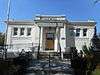 |
(#15000517) |
117 W. Main St. 40°41′46″N 73°19′31″W / 40.6961°N 73.3253°W |
Babylon | Neoclassical 1911 building was part of early wave of public libraries built in small towns across the country during the first decades of the 20th century. More info here. |
| 2 | Babylon Town Hall | 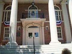 |
(#05001131) |
47 West Main Street 40°41′51″N 73°19′36″W / 40.6975°N 73.326667°W |
Babylon | |
| 3 | Long Island National Cemetery | 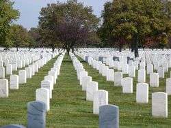 |
(#16000113) |
2040 Wellwood Ave., 40°45′27″N 73°23′48″W / 40.75750°N 73.39667°W |
Wyandanch | Veterans' cemetery shared with town of Huntington to north built in 1930s to handle overflow from Cypress Hills soon expanded to take in 10,000 World War II veterans and POWs. |
| 4 | Nathaniel Conklin House | .jpg) |
(#88002683) |
280 Deer Park Avenue 40°42′02″N 73°19′23″W / 40.700556°N 73.323056°W |
Babylon | |
| 5 | Sisters of St. Dominic Motherhouse Complex | .JPG) |
(#07000625) |
555 Albany Avenue 40°42′18″N 73°24′14″W / 40.705°N 73.403889°W |
North Amityville | |
| 6 | Frank W. Smith House | 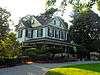 |
(#10000797) |
43 Barberry Court 40°40′27″N 73°24′42″W / 40.674167°N 73.411667°W |
Amityville |
See also
| Wikimedia Commons has media related to National Register of Historic Places in Suffolk County, New York. |
- National Register of Historic Places listings in New York
- National Register of Historic Places listings in Suffolk County, New York
References
- ↑ The latitude and longitude information provided is primarily from the National Register Information System, and has been found to be fairly accurate for about 99% of listings. For 1%, the location info may be way off. We seek to correct the coordinate information wherever it is found to be erroneous. Please leave a note in the Discussion page for this article if you believe any specific location is incorrect.
- ↑ Numbers represent an ordering by significant words. Various colorings, defined here, differentiate National Historic Landmarks and historic districts from other NRHP buildings, structures, sites or objects.
- ↑ The eight-digit number below each date is the number assigned to each location in the National Register Information System database, which can be viewed by clicking the number.
| Topics |   | |
|---|---|---|
| Lists by county |
| |
| Lists by city | ||
| Other lists | ||
| ||
This article is issued from Wikipedia - version of the 10/21/2016. The text is available under the Creative Commons Attribution/Share Alike but additional terms may apply for the media files.