Prunay-le-Temple
| Prunay-le-Temple | |
|---|---|
|
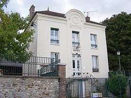
Town hall | |
 Prunay-le-Temple | |
|
Location within Île-de-France region  Prunay-le-Temple | |
| Coordinates: 48°51′43″N 1°40′28″E / 48.8619°N 1.6744°ECoordinates: 48°51′43″N 1°40′28″E / 48.8619°N 1.6744°E | |
| Country | France |
| Region | Île-de-France |
| Department | Yvelines |
| Arrondissement | Mantes-la-Jolie |
| Canton | Houdan |
| Intercommunality | Pays houdanais |
| Government | |
| • Mayor (2001–2008) | Louis Aubry |
| Area1 | 6.77 km2 (2.61 sq mi) |
| Population (2006)2 | 363 |
| • Density | 54/km2 (140/sq mi) |
| Time zone | CET (UTC+1) |
| • Summer (DST) | CEST (UTC+2) |
| INSEE/Postal code | 78505 / 78910 |
| Elevation |
67–153 m (220–502 ft) (avg. 100 m or 330 ft) |
|
1 French Land Register data, which excludes lakes, ponds, glaciers > 1 km² (0.386 sq mi or 247 acres) and river estuaries. 2 Population without double counting: residents of multiple communes (e.g., students and military personnel) only counted once. | |
Prunay-le-Temple is a commune in the Yvelines department in the Île-de-France in north-central France. Its area covers about 2.6 square miles on the plateau of Mantois. The altitude is generally between 100–130 meters, sloping slightly towards North.
See also
References
| Wikimedia Commons has media related to Prunay-le-Temple. |
This article is issued from Wikipedia - version of the 12/8/2015. The text is available under the Creative Commons Attribution/Share Alike but additional terms may apply for the media files.