Rockland Road Bridge Historic District
|
Rockland Road Bridge Historic District | |
|
264 Piermont Avenue | |
  | |
| Location | Ferdon Ave., Rockland Rd. & S. Piermont Ave., Piermont, New York |
|---|---|
| Coordinates | 41°02′06″N 73°55′10″W / 41.03500°N 73.91944°WCoordinates: 41°02′06″N 73°55′10″W / 41.03500°N 73.91944°W |
| Area | 5.38 acres (2.18 ha) |
| Built | c. 1785-1940 |
| Architect | Hand, William |
| Architectural style | Federal, Greek Revival, Italianate, Second Empire |
| NRHP Reference # | 11000709[1] |
| Added to NRHP | September 29, 2011 |
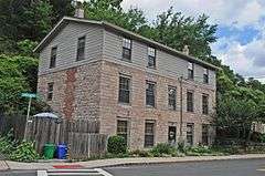
Rockland Road Bridge Historic District is a national historic district located at Piermont in Rockland County, New York. The district encompasses 12 contributing buildings and 8 contributing structures in the village of Piermont. It developed between about 1785 and 1940, and includes representative examples of Federal, Greek Revival, Italianate, and Second Empire style architecture. Located in the district are the separately listed William Ferdon House, Haddock's Hall, and the Rockland Road Bridge. Other notable buildings and structures include the Sparkill Pump House and Dam (c. 1940), "Protection Engine Company" (c. 1854 and later), and The Mine Hole.[2]
It was listed on the National Register of Historic Places in 2011.[1]
References
- 1 2 "National Register of Historic Places Listings". Weekly List of Actions Taken on Properties: 9/26/11 through 9/30/11. National Park Service. 2011-10-07.
- ↑ "Cultural Resource Information System (CRIS)" (Searchable database). New York State Office of Parks, Recreation and Historic Preservation. Retrieved 2015-12-01. Note: This includes William E. Krattinger (October 2010). "National Register of Historic Places Registration Form: Rockland Road Bridge Historic District" (PDF). Retrieved 2015-12-01. and Accompanying photographs
| Topics |   | |
|---|---|---|
| Lists by county |
| |
| Lists by city | ||
| Other lists | ||
| ||
This article is issued from Wikipedia - version of the 12/2/2016. The text is available under the Creative Commons Attribution/Share Alike but additional terms may apply for the media files.