The Point Historic District
|
The Point Historic District | |
|
Macomb Street | |
  | |
| Location | Roughly bounded by Jay, Hamilton, Peru, and Bridge Sts., Plattsburgh, New York |
|---|---|
| Coordinates | 44°41′44″N 73°26′49″W / 44.69556°N 73.44694°WCoordinates: 44°41′44″N 73°26′49″W / 44.69556°N 73.44694°W |
| Area | 16 acres (6.5 ha) |
| Built | c. 1815 |
| Architectural style | Mid 19th Century Revival, Late Victorian, Federal |
| MPS | Plattsburgh City MRA |
| NRHP Reference # | 82001110[1] |
| Added to NRHP | November 12, 1982 |
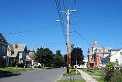
The Point is a national historic district located at Plattsburgh, Clinton County, New York. It encompasses 33 contributing buildings and contains a collection of historic homes dating from about 1815. The district is adjacent to the historic D & H Railroad Complex and also Plattsburgh Bay, an arm of Lake Champlain. It is bounded by the railroad from the north, by Plattsburgh Bay from the east, and by the Saranac River, which separates it from downtown Plattsburgh, from the west.[2]:5
The historic district was added to the National Register of Historic Places on November 12, 1982.[1]
Gallery
 44 Pike Street, a contributing property
See also
References
- 1 2 National Park Service (2010-07-09). "National Register Information System". National Register of Historic Places. National Park Service.
- ↑ "Cultural Resource Information System (CRIS)" (Searchable database). New York State Office of Parks, Recreation and Historic Preservation. Retrieved 2015-11-01. Note: This includes unknown (n.d.). "National Register of Historic Places Registration Form: The Point Historic District" (PDF). Retrieved 2015-11-01. and Accompanying photographs
| Topics |   | |
|---|---|---|
| Lists by county |
| |
| Lists by city | ||
| Other lists | ||
| ||
This article is issued from Wikipedia - version of the 11/29/2016. The text is available under the Creative Commons Attribution/Share Alike but additional terms may apply for the media files.