Valcour Bay
|
Valcour Bay | |
|
Bay in 2012 | |
 | |
| Location |
Lake Champlain; Clinton County, New York |
|---|---|
| Nearest city | Plattsburgh, NY |
| Coordinates | 44°37′4″N 73°25′57″W / 44.61778°N 73.43250°WCoordinates: 44°37′4″N 73°25′57″W / 44.61778°N 73.43250°W |
| Area | 1,200 acres (490 ha) |
| NRHP Reference # | 66000508[1] |
| Significant dates | |
| Added to NRHP | October 15, 1966 |
| Designated NHL | January 1, 1961[2] |
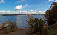
Valcour Bay is a strait between Valcour Island and the west side of Lake Champlain, four miles south of Plattsburgh, New York. It was the site of the Battle of Valcour Island during the American Revolutionary War. It was declared a National Historic Landmark in 1961.[2][3] Valcour Bay is located in the Towns of Peru and Plattsburgh, both in Clinton County, New York.
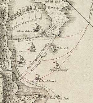
A 1776 map showing the Battle of Valcour Bay
The USS Philadelphia, which was sunk during the battle, was raised in 1935 and is on display at the Smithsonian Institution in Washington, D.C. It was also declared a National Historic Landmark in 1961.
See also
- List of National Historic Landmarks in New York
- National Register of Historic Places listings in Clinton County, New York
References
- ↑ National Park Service (2010-07-09). "National Register Information System". National Register of Historic Places. National Park Service.
- 1 2 "Valcour Bay". National Historic Landmark summary listing. National Park Service. 2007-09-21.
- ↑ Richard Greenwood (December 12, 1975). "National Register of Historic Places Inventory-Nomination: Valcour Bay" (pdf). National Park Service. and Accompanying 1 photo from 1975. (205 KB)
| Topics |   | |
|---|---|---|
| Lists by county |
| |
| Lists by city | ||
| Other lists | ||
| ||
This article is issued from Wikipedia - version of the 11/26/2016. The text is available under the Creative Commons Attribution/Share Alike but additional terms may apply for the media files.