Acteon Group
The Acteon Group (Groupe Actéon) is a rather isolated and uninhabited subgroup in the far southeast of the Tuamotu atoll group in French Polynesia. It is located about 1,400 km (870 mi) east-southeast of Tahiti at latitude: 21° 17' 60 S, longitude: 136° 29' W.[1]
Atolls
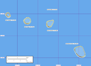
The Acteon Group includes four atolls of relatively small size:
None of the islands on these atolls have permanent inhabitants.
History
The first recorded European to sight the Acteon Group was Pedro Fernández de Quirós on 5 February 1605. He described the group as "four islands crowned by coconut palms". On the different texts describing his voyage by other members of this Spanish expedition they were charted as "Las Cuatro Coronadas" (The four Crowned), "Las Cuatro Hermanas" (The Four Sisters), "Las Virgenes" (The Virgins) or "Las Anegadas" (The Flooded ones).[2]
A rediscovery of this group is generally credited to Thomas Ebrill, captain of the Tahitian trading vessel Amphitrite, who discovered these islands in 1833. However, they were named 4 years later by Lord Edward Russell – commander of the HMS Actaeon (1831) – after his vessel. In 1983 these atolls were struck by a cyclone.[3]
Administration
Administratively the four atolls of the Acteon group belong to the commune of the Gambier Islands.
References
- ↑ "Oceandots – Actéon". Archived from the original on 2010-12-23. Retrieved 2009-03-14.
- ↑ Brand, Donald D. The Pacific Basin: A History of its Geographical Explorations The American Geographical Society, New York, 1967, p.136.
- ↑ – History
External links
Tuamotus Gambiers | Islands/Atolls: | ||
|---|---|---|---|
| Island groups: | |||
Coordinates: 21°22′59″S 136°34′59″W / 21.383°S 136.583°W