Apataki
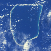
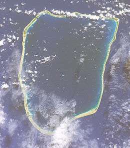 NASA picture of Apataki Atoll | |
 Apataki | |
| Geography | |
|---|---|
| Location | Pacific Ocean |
| Coordinates | 17°48′22″S 140°45′39″W / 17.80611°S 140.76083°WCoordinates: 17°48′22″S 140°45′39″W / 17.80611°S 140.76083°W |
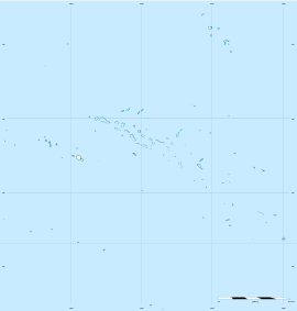
| Archipelago | Tuamotus |
| Area |
706 km2 (273 sq mi) (lagoon) 20 km2 (8 sq mi) (above water) |
| Length | 34 km (21.1 mi) |
| Width | 24 km (14.9 mi) |
| Administration | |
|
France | |
| Overseas collectivity | French Polynesia |
| Administrative subdivision | Tuamotus |
| Commune | Arutua |
| Largest settlement | Niutahi |
| Demographics | |
| Population | 350[1] (2012) |
| Pop. density | 18 /km2 (47 /sq mi) |
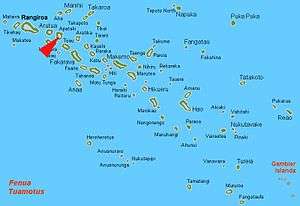
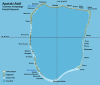
Apataki[2] is a coral atoll in the South Pacific Ocean, territorially part of French Polynesia. It is one of the Palliser Islands, a subgroup of the Tuamotu Archipelago. Apataki is located approximately 370 kilometres (230 miles) northeast of the island of Tahiti, 17 km (11 mi) east of Arutua and 24 km (15 mi) northeast of Kaukura. The island is approximately rectangular; it is 34 km (21 mi) long and 24 km (15 mi) wide. It has a total area of approximately 706 km2 with a land area of approximately 20 km2 (8 sq mi). Its wide lagoon has two navigable passes to enter it.
As of 2012, Apataki Atoll has 350 inhabitants, down from 492 in 2007. The main village is called Niutahi.
History
The first recorded European to sight Apataki Atoll was Dutch navigator Jakob Roggeveen in 1722. It was visited by James Cook in 1774.
Apataki appears in some maps as "Hagemeister Island".[3]
On 27 May 1902, while Paul Gauguin was living in the Marquesas Islands, the mail-boat Croix du Sud between Papeete and Atuona was shipwrecked at Apataki. leading to a three-month loss of supplies for the islanders.[4][5]
There is a territorial (domestic) airfield in Apataki which was inaugurated in 1977.
Administration
Administratively, Apataki Atoll is part of the commune of Arutua.
Images & Maps
|
.jpg)
Economy
Apataki has an airport but no tourism industry. The only main industry of the island is cultured Tahitian (black) pearls. The coconut palm, which forms the basis for copra (dried coconut) production, used to be of special economic importance to the islanders. On a few islands, the residents cultivate vanilla. Agriculture is generally limited to simple subsistence. Pandanus leaves are traditionally woven together as roof thatch (although corrugated sheet metal is also used today), as well as for other items such as mats and hats.
Apataki's two large reef passes provide excellent diving and surfing, both of which are serviced by local boat-based charter companies. Land-based accommodations do not exist.
Cuisine
Fruit and vegetable staples include yams, taro, and breadfruit, as well as a wide range of tropical fruits.
Flora and fauna
The sparse soil of Apataki cannot sustain a great variety of vegetation.
The animal life on the islands consists mostly of seabirds, landcrabs, insects, and lizards. The underwater fauna, however, is rich and varied, making scuba diving a popular activity for tourists.
References
- ↑ "Population". Institut de la statistique de la Polynésie française. Retrieved 24 September 2014.
- ↑ Young, J.L. (1899). "Names of the Paumotu Islands, with the old names so far as they are known.". Journal of the Polynesian Society. 8 (4): 264–268. Retrieved 7 January 2015.
- ↑ A Directory for the Navigation of the South Pacific Ocean, p. 579, at Google Books>
- ↑ Bengt Danielsson, Gauguin in the South Seas, 1965, George Allen and Unwin, pp. 252, 263
- ↑ "Union Steam Ship Company of New Zealand". theshipslist.com.
- "Apataki Atoll". NASA Earth Observatory Newsroom. Retrieved 2006-04-27.
- Oceandots
External links
- Apataki Atoll FP (EVS Islands)
- Shuttle Image ISS006-E-38475 (Astronaut Photography)
- Apatika Atoll FP (Oceandots.com) at the Wayback Machine (archived December 23, 2010)
- Tuamotu Atolls List (Pacific Image)
See also
Tuamotus Gambiers | Islands/Atolls: | ||
|---|---|---|---|
| Island groups: | |||