Tikehau
|
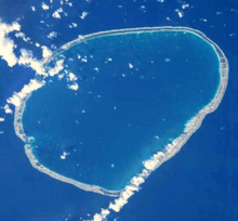
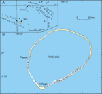
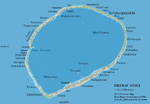
Satellite photograph of Tikehau Atoll. | |
 Tikehau | |
| Geography | |
|---|---|
| Location | Pacific Ocean |
| Coordinates | 15°4′12″S 148°7′48″W / 15.07000°S 148.13000°WCoordinates: 15°4′12″S 148°7′48″W / 15.07000°S 148.13000°W |
| Archipelago | Tuamotus |
| Area |
461 km2 (178 sq mi) (lagoon) 20 km2 (8 sq mi) (above water) |
| Length | 27 km (16.8 mi) |
| Width | 19 km (11.8 mi) |
| Highest elevation | 8 m (26 ft) |
| Administration | |
|
France | |
| Overseas collectivity | French Polynesia |
| Administrative subdivision | Tuamotus |
| Commune | Rangiroa |
| Demographics | |
| Population | 529[1] (2012) |
Tikehau (meaning Peaceful Landing in Tuamotuan[2]) or Porutu-kai is a coral atoll in the Palliser Islands group, part of the Tuamotu Archipelago in French Polynesia. It is included in the commune of Rangiroa.
Geography
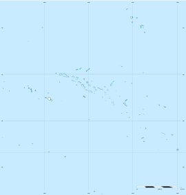
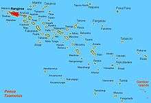
Tikehau is located 340 kilometres (210 miles) northeast of Tahiti in the Tuamotu Islands. The nearest atoll, Rangiroa, lies only 12 kilometres (7.5 miles) to the east. Mataiva, the westernmost atoll of the same group, is located 35 kilometres (22 miles) to the west.
The atoll's oval-shaped lagoon is 27 kilometres (17 miles) long and 19 kilometres (12 miles) wide with a lagoon area of about 461 square kilometres (178 square miles). The atoll is made up of two major islands and numerous islets. The northeastern quarter of the atoll is a single, mostly uninhabited island. The whole atoll is surrounded by an almost continuous coral reef. There is a single pass deep and wide enough for navigation in and out of the lagoon: Tuheiava Pass is located on the western shore. The islands and islets are covered with coconut palms. The main village is called Tuherahera.
History
The first recorded European to arrive to Tikehau was the Russian mariner Otto von Kotzebue. He called this atoll Krusenstern Island,[lower-alpha 1] after Russian explorer Adam Johann von Krusenstern. The Wilkes Expedition passed by this atoll on 9 September 1839.
On a visit in 1987, Jacques Cousteau's research group made a study of Tikehau's lagoon and discovered that it contains a greater variety of fish species than any other place in French Polynesia.
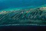
Today, Tikehau is a tourist destination, popular for its pink sand beaches and its exceptional underwater fauna.
Transportation
Tikehau Airport, located on the southern tip of the atoll, was inaugurated in 1977. There are daily flights to and from Tahiti and other atolls of the Tuamotus.
Additional photographs and maps
|
.jpg)
_Finished.jpg)

Notes
- ↑ Krusenstern Island may also refer to other places; see Krusenstern Island (disambiguation)
References
- ↑ "Population". Institut de la statistique de la Polynésie française. Retrieved 22 September 2014.
- ↑ Official Tikehau Tourism Site Publisher: Tahiti Tourisme. Accessed 16 February 2010
External links
| Wikimedia Commons has media related to Tikehau. |
| Wikivoyage has a travel guide for Tikehau. |
- Article from Hydrobiologia
- Atoll names
- Wilkes Expedition
- Historical data
- Birds in Tikehau
- Tikehau Atoll FP (EVS Islands)
- Shuttle Image ISS008-E-17132 (Astronaut Photography)
- Tikehau Atoll FP (Oceandots.com) at the Wayback Machine (archived December 23, 2010)
- Tuamotu Atolls List (Pacific Image)
- High-resolution picture from the Earth Observatory
Tuamotus Gambiers | Islands/Atolls: | ||
|---|---|---|---|
| Island groups: | |||