Tenararo
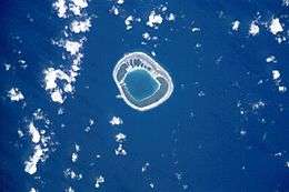 NASA picture of Tenararo Atoll | |
 Tenararo | |
| Geography | |
|---|---|
| Location | Pacific Ocean |
| Coordinates | 21°18′S 136°45′W / 21.300°S 136.750°WCoordinates: 21°18′S 136°45′W / 21.300°S 136.750°W |
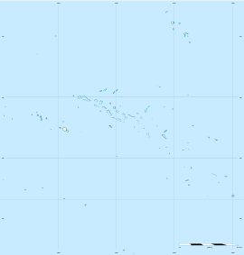
| Archipelago | Tuamotus |
| Area |
2 km2 (0.77 sq mi) (lagoon) 1.6 km2 (0.6 sq mi) (above water) |
| Administration | |
|
France | |
| Overseas collectivity | French Polynesia |
| Administrative subdivision | Tuamotus |
| Commune | Gambier Islands |
| Demographics | |
| Population | Uninhabited[1] (2012) |
Tenararo is the smallest atoll in the Acteon Group in the southeastern part of the Tuamotu Islands in French Polynesia. It is administratively a part of the Gambier Islands. It is uninhabited.
Geography
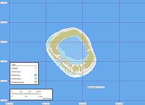
Tenararo is located 6 kilometres (4 miles) west of Vahanga, the nearest island, 115 kilometres (71 miles) west of the Gambier Islands and 1,370 kilometres (850 miles) southeast of Tahiti. It is a circular atoll with a land area of 1.6 square kilometres (0.6 square miles) and a land area of 2 square kilometres (0.8 square miles). The atoll has a landing place on its NW side between the small boulders which encumber the reef. There is no entrance to the lagoon.
History
The first recorded sighting of this atoll was made during the Spanish expedition of the Portuguese navigator Pedro Fernández de Quirós on 5 February 1606 under the name Las Cuatro Coronadas (the "four crowned" (by coconut palms)),[2][3] however these observations were not fully documented. As such, the first unambiguous approach to the island was made in 1833 by navigator Thomas Ebrill on his merchant vessel Amphitrite and again in 1837 by Lord Edward Russell, commander of the H.M.S Actaeon, the name given to the group.[4] It was previously owned by a man named Captain Nicholas but was redeemed in 1934.[5]
In the nineteenth century, Tenararo became a French territory, with a population of about 20 Aboriginal people in 1850.[6]
Flora and fauna
The atoll is an important habitat for many endangered species. Species such as the Polynesian ground dove (of which there are less than 120 remaining in the wild), atoll fruit dove, Tuamotu sandpiper, bristle-thighed curlew and Murphy's petrel live on the island.[7] The atoll is free of introduced mammalian predators, making it an essential conservational habitat.
See also
External links
References
- ↑ "Population". Institut de la statistique de la Polynésie française. Retrieved 26 September 2014.
- ↑ Brand, Donald D. The Pacific Basin: A History of its Geographical Explorations The American Geographical Society, New York, 1967, p.136.
- ↑ Kelly, Celsus, O.F.M. La Australia del Espiritu Santo. The Journal of Fray Martín de Munilla O.F.M. and other documents relating to the Voyage of Pedro Fernández de Quirós to the South Sea (1605-1606) and the Franciscan Missionary Plan (1617-1627) Cambridge, 1966, p.39,62.
- ↑ Pacific Island: Eastern-Pacific - Geographical handbook series, James Wightman Davidson and Naval Intelligence Division, editions Naval Intelligence Division, 1945, p.224.
- ↑ Archaeology of Mangareva and neighboring atolls by Kenneth Pike Emory, editions Kraus, 1971, p.58-60.
- ↑ Notices sur les colonies françaises, Étienne Avalle, éditions Challamel aîné, Paris, 1866, p.642 Google Books
- ↑ Dahl, prepared by the International Union for Conservation of Nature and Natural Resources, Commission on National Parks and Protected Areas ; in collaboration with the United Nations Environment Programme ; based on the work of Arthur Lyon (1986). Review of the protected areas system in Oceania (Sept. 1986. ed.). Gland, Switzerland: IUCN. ISBN 9782880325091.
- Sailing Directions, Pub 126, "Pacific Islands" NIMA 2002; page-12
Tuamotus Gambiers | Islands/Atolls: | ||
|---|---|---|---|
| Island groups: | |||