Marutea Sud
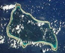 NASA picture of Marutea Sud Atoll | |
 Marutea Sud | |
| Geography | |
|---|---|
| Location | Pacific Ocean |
| Coordinates | 21°31′S 135°33′W / 21.517°S 135.550°WCoordinates: 21°31′S 135°33′W / 21.517°S 135.550°W |
| Archipelago | Tuamotus |
| Area |
112 km2 (43 sq mi) (lagoon) 14 km2 (5.4 sq mi) (above water) |
| Length | 20 km (12 mi) |
| Width | 8 km (5 mi) |
| Administration | |
|
France | |
| Overseas collectivity | French Polynesia |
| Administrative subdivision | Tuamotus |
| Commune | Gambier Islands |
| Largest settlement | Auorotini |
| Demographics | |
| Population | 111[1] (2012) |
Marutea Atoll (Marutea Sud), also known as Marutea-i-runga, and Nuku-nui, is an atoll of the Tuamotu group in French Polynesia. It is located in the far southeast of the archipelago, about 72 km northeast from Maria Atoll.
Marutea Atoll is irregular in shape and bound by a reef broken by passes into the 112 km2 lagoon. It is 20 km long with a maximum width of 8 km and a land area of approximately 14 km2. Its islands are low and flat and the main village, Auorotini, is located at the northern end of the atoll. Marutea has no permanent population, but it is occasionally visited by islanders looking for pearls and maintaining the pearl farms.
Marutea Sud should not be confused with Marutea Nord located in the western area of the Tuamotu Archipelago at 17˚ 07' S, 143˚ 11' W.
History
The first recorded European to sight this atoll was Spanish explorer Pedro Fernández de Quirós on 4 February 1606. He called it San Telmo. Other Spanish names were San Blas, given by de Quiros' captain Diego de Prado y Tovar, and Corral de Agua is found in some contemporary charts (in Spanish, water corral).[2] Marutea was later explored by Edward Edwards, while he was searching for the mutineers of the HMS Bounty in 1791. Edwards renamed it "Lord Hood".
According to Russian Admiral Adam Johann von Krusenstern Marutea was once inhabited by the ancient Polynesians. British mariner Frederick William Beechey found a stone walled hut upon it in 1825.
In 1984 Marutea Atoll was bought by Robert Wan, the main Tahitian black pearl trader, in order to engage in cultured black pearl farming.
A private airfield was built in 1993.
Administration
Administratively Marutea Sud belongs to the commune of the Gambier Islands.
References
- ↑ "Population". Institut de la statistique de la Polynésie française. Retrieved 6 October 2014.
- ↑ Kelly, Celsus, O.F.M. La Austrialia del Espiritu Santo. The Journal of Fray Martín de Munilla O.F.M. and other documents relating to the Voyage of Pedro Fernández de Quirós to the South Sea (1605–1606) and the Franciscan Missionary Plan (1617–1627) Cambridge, 1966, p.39, 62.
External links
Tuamotus Gambiers | Islands/Atolls: | ||
|---|---|---|---|
| Island groups: | |||