Two Groups Islands
Coordinates: 18°08′S 142°15′W / 18.133°S 142.250°W
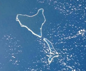
The Two Groups Islands (French: Îles Deux Groupes) is a minor subgroup of the Tuamotus in French Polynesia. It is formed by the atolls of Marokau to the north (populated by 100 people)[1] and the uninhabited Ravahere to the south.[2] The two atolls are separated by a 2 km (1 mi) wide sound.[3]
History
These two neighboring atolls were discovered by Louis Antoine de Bougainville in 1768.[4] It was James Cook, however, who named them "Two Groups" the following year. He described Marokau and Revahere as a "chain of islands linked by reefs".[5]
Administration
Administratively the Two Groups Islands belong form the territory of the associated commune of Marokau, itself part of the commune of Hikueru, which consists of the two atolls of the Two Groups Islands (Marokau and Ravahere) and the three atolls of the associated commune of Hikueru (Hikueru, Reitoru and Tekokota).
References
- ↑ Oceandots - Ravahere at the Wayback Machine (archived December 23, 2010)
- ↑ Oceandots - Marokau at the Wayback Machine (archived December 23, 2010)
- ↑ Geonames - Îles Deux Groupes
- ↑ Photo satellite des Îles Deux Groupes (Archipel des Tuamotu)
- ↑ Charles Pierre Claret de Fleurieu et al. Discoveries of the French in 1768 and 1769, to the south-east of New Guinea, J. Stockdale, 1791
External links
Tuamotus Gambiers | Islands/Atolls: | ||
|---|---|---|---|
| Island groups: | |||