Makaroa
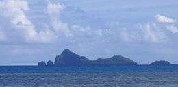 View of Makaroa Island | |
 Makaroa | |
| Geography | |
|---|---|
| Location | Pacific Ocean |
| Coordinates | 23°13′08″S 134°58′16″W / 23.21889°S 134.97111°WCoordinates: 23°13′08″S 134°58′16″W / 23.21889°S 134.97111°W |
| Archipelago | Tuamotus |
| Area | 0.2 km2 (0.077 sq mi) |
| Length | 1.3 km (0.81 mi) |
| Highest elevation | 138 m (453 ft) |
| Highest point | (unnamed) |
| Administration | |
|
France | |
| Overseas collectivity | French Polynesia |
| Administrative subdivision | Tuamotus |
| Commune | Gambier Islands |
| Demographics | |
| Population | Uninhabited[1] (2012) |
Makaroa is an island in the Gambier Islands of French Polynesia, 8.5 km south of Mangareva within the same lagoon. Makaroa is about 1.3 km (1 mi) in length and has a small rocky islet off its NW point.
Makaroa is uninhabited. It is a jagged and barren island with a maximum height of 138 m. 1.8 km (1 mi) to the SSE lies Kamaka Island.[2]
References
- ↑ "Population". Institut de la statistique de la Polynésie française. Retrieved 2 October 2014.
- ↑ David Stanley, Tahiti-Polynesia handbook
External links
| Wikimedia Commons has media related to Makaroa. |
Tuamotus Gambiers | Islands/Atolls: | ||
|---|---|---|---|
| Island groups: | |||
This article is issued from Wikipedia - version of the 11/17/2016. The text is available under the Creative Commons Attribution/Share Alike but additional terms may apply for the media files.