Fakahina
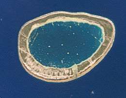 NASA picture of Fakahina Atoll | |
 Fakahina | |
| Geography | |
|---|---|
| Location | Pacific Ocean |
| Coordinates | 15°59′S 140°11′W / 15.983°S 140.183°WCoordinates: 15°59′S 140°11′W / 15.983°S 140.183°W |
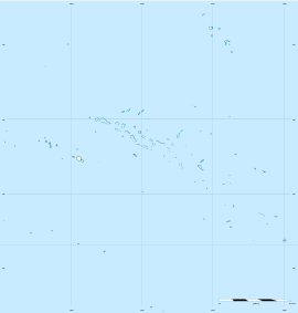
| Archipelago | Tuamotus |
| Area |
20 km2 (7.7 sq mi) (lagoon) 8 km2 (3 sq mi) (above water) |
| Length | 9 km (5.6 mi) |
| Width | 6.3 km (3.91 mi) |
| Administration | |
|
France | |
| Overseas collectivity | French Polynesia |
| Administrative subdivision | Tuamotus |
| Commune | Fangatau |
| Largest settlement | Tarione |
| Demographics | |
| Population | 155[1] (2012) |
| Pop. density | 19 /km2 (49 /sq mi) |

Fakahina, or Kaīna,[2] is a small atoll in the west of the Tuamotu group in French Polynesia. The nearest land is Fangatau Atoll, located 72 km to the WNW.
Fakahina Atoll's length is 9 kilometres (5.6 miles) and its maximum width 6.3 kilometres (3.9 miles). It has a land area of 8 square kilometres (3 square miles) and a lagoon area of 20 square kilometres (8 square miles). There is no pass connecting the lagoon with the ocean.
Fakahina has 155 inhabitants. The main village is Tarione.
History
The ancient Ma'ohi people used this atoll as a site for sacrifices.
The first recorded European to arrive to Fakahina Atoll was Otto von Kotzebue, sailing in the service of the Russian tsars, in 1824. This atoll appears as "Predpriati" in some maps.
Part of the population of Fakahina was moved to Puka-Puka to work in the production of copra.
There is a territorial (domestic) airfield in Fakahina which was inaugurated in 1985.
Administration
Fakahina belongs to the commune of Fangatau, which consists of Fangatau Atoll, as well as the atoll and associated commune of Fakahina.
References
- ↑ "Population". Institut de la statistique de la Polynésie française. Retrieved 25 September 2014.
- ↑ Young, J.L. (1899). "Names of the Paumotu Islands, with the old names so far as they are known.". Journal of the Polynesian Society. 8 (4): 264–268. Retrieved 7 January 2015.
External links
Tuamotus Gambiers | Islands/Atolls: | ||
|---|---|---|---|
| Island groups: | |||