Ahaxe-Alciette-Bascassan
| Ahaxe-Alciette-Bascassan | |
|---|---|
 | |
 Ahaxe-Alciette-Bascassan | |
|
Location within Nouvelle-Aquitaine region  Ahaxe-Alciette-Bascassan | |
| Coordinates: 43°09′04″N 1°09′50″W / 43.151°N 1.164°WCoordinates: 43°09′04″N 1°09′50″W / 43.151°N 1.164°W | |
| Country | France |
| Region | Nouvelle-Aquitaine |
| Department | Pyrénées-Atlantiques |
| Arrondissement | Bayonne |
| Canton | Saint-Jean-Pied-de-Port |
| Intercommunality | Garazi-Baïgorri |
| Government | |
| • Mayor (2014–2020) | Jean-Paul Bidart |
| Area1 | 14.64 km2 (5.65 sq mi) |
| Population (2010)2 | 291 |
| • Density | 20/km2 (51/sq mi) |
| Time zone | CET (UTC+1) |
| • Summer (DST) | CEST (UTC+2) |
| INSEE/Postal code | 64008 / 64220 |
| Elevation |
207–788 m (679–2,585 ft) (avg. 265 m or 869 ft) |
|
1 French Land Register data, which excludes lakes, ponds, glaciers > 1 km² (0.386 sq mi or 247 acres) and river estuaries. 2 Population without double counting: residents of multiple communes (e.g., students and military personnel) only counted once. | |
Ahaxe-Alciette-Bascassan (Basque: Ahatsa-Alzieta-Baskazane) is a French commune in the Pyrénées-Atlantiques department in the Nouvelle-Aquitaine region in southwestern France.
The people of the commune are known as Ahastarr.[1]
Geography
Location
Ahaxe-Alciette-Bascassan is part of Cize country (or Garazi in Basque) which was a historical province in Lower Navarre. It includes three former parishes, sometimes counted as four groups of houses in the Middle Ages[2] and with five toponyms: Alciette, Ahaxe, Garatehegi, Ligeta, and Bascassan located at the confluence of the Laurhibar and Esteneko streams.
Alciette is the parish farthest away to the northeast in the combination of the three parishes.
Ahaxe-Alciette-Bascassan is located some 6 km south-east of Saint-Jean-Pied-de-Port and can be accessed by Highway D18 running from close to there through the heart of the commune southeast to Lecumberry. The village is not on the highway and is left onto the country road Vierge-d'Ahaxe off the D18 heading southeast. There is a country road from Aincille in the west to the village of Bascassin in the commune and there are other country roads entering from the north and the southeast.[3]
Hydrography
The commune is located in the Drainage basin of the Adour, the commune lands are watered by the Laurhibar, a tributary of the Nive, and a tributary of that, the Esteneko stream. The Apatéko stream, a tributary of the Arzubiko stream also crosses the territory of Ahaxe-Alciette-Bascassan.
Localities and hamlets[4]
- Aguerréa
- Ahatsaxilo (former parish)[5]
- Ahaxamendy[6]
- Ahaxe
- Alciette
- Bascassan
- Bastida[7]
- Bernetcheko Borda
- Bidartéa
- Bordes (2 places)
- Buirguista
- Buluntza
- Chilinchabidéa
- Chilo
- Curutchet (or Garat)[8]
- Dorrea[9]
- Errékaldéa
- Erromatéguia (2 places)
- Etcheverria[10]
- Garatehegi[2][11]
- Garatéko Eyhéra
- Gastelua[12]
- Gastalepo
- Haraune
- Harguindéguia
- Idioinea[13]
- Irahane
- Iriberria
- Irigaraya
- Irustikoborda
- Italatzé
- Kapila
- Larluzia
- Libiéta[14]
- Lietamendy
- Ligeta[2]
- Olherry
- Orido
- Ospitaletchia
- Sagardoyguibel
- Seineguy
- Uhaïtzia
- Urrutia
Neighbouring Communes and Villages
 |
Saint-Jean-le-Vieux | Bussunarits-Sarrasquette | Ibarrolle | |
| Aincille | |
Hosta | ||
| ||||
| | ||||
| Saint-Michel | Esterencuby | Lecumberry |
Toponymy
The commune's name in Basque is Ahatsa-Altzieta Bazkazane.[15]
- Ahaxe
The toponym Ahaxe appears in the forms:
- Hatce (1167)[15]
- Fax (1194)[2]
- domine de ahacha (1194)[2]
- Assa, Aassa, and Hassa (1249)[15]
- Ahatxa (1300)[15]
- Ahaxa (1302[16] Chapter of Bayonne[17])
- Haxa and Ahaxe (1304)[15]
- Axa (1309[15] and 1350[2])
- Hatxa (1350)[15]
- Hadssa (1366)[15]
- Ahtxe (1703[16]), Visits of Bayonne[18]
- Sanctus Julianus Ahaxe (1757,[16] Diocese of Bayonne collections[19]).
Jean-Baptiste Orpustan[2] indicates that the toponym comes from the Basque oronymic base of (h)aitz meaning "rock" or "height".
The people of the commune are called in Basque Ahatsarr.[2]
- Alciette
The toponym Alciette appears in the forms:
- Alsuete (1249)[2]
- La Grange Alsuete (1302,[20] Chapter of Bayonne[17])
- Alçueta (1305)[15]
- Alzueta (1513,[20] Titles of Pamplona[21])
- Alçuete and Alçueta (1350)[15])
- Alchuete (1387)[15]
- Alchuette (1387)[2]
- Alçueta (1621,[20] Martin Biscay[22])
- Alsiette (1667,[20] regulations of the States of Navarre[23])
The Basque name for the people of this area is Alzietarr.[2]
According to Jean-Baptiste Orpustan,[2] Alciette is derived from the medieval Alzueta which itself comes from the Basque alzu meaning "place where there are abundant alder trees".
- Bascassan
The name Bascassan appears in the forms:
- Bazquazen (1208)[2]
- Bascaçen (1292)[15]
- Bascacen (1350)[15])
- Bazcacen (1366)[15])
- Basquacen (1413)[15])
- Bazcacen (1513,[24] Titles of Pamplona[21])
- Vazquacen (1613)[2]
- Vazcazen and Vazaçan (1621[24] Martin Biscay[22])
- Bascassan (1789)[2]
Its origin is uncertain.[2] The people of the area are called Bazkazandarr in basque.[2]
Ahaxachillo is mentioned in the 1863 dictionary.[5])
Bastida is also indicated by Raymond.[7]
Errékaldéa is mentioned with the spelling Errecaldia referring to the flowing stream of Bascassan flowing into the Laurhibar.[25]
- Curutchet
Curutchet (also called Garat) was a former fief of Ahaxe, a vassal of the Kingdom of Navarre.[8]
- Etcheverria
Paul Raymond mentioned an Etcheberry, a fief located in the parish of Alciette and a vassal of the Kingdom of Navarre.[10]
- Garatehegi
The name Garatehegi appears in the forms:
- Garateguia (1350)[2]
- sent jullian et garateheguj (1366)[2]
- la parropie de garatehegi (1413)[2]
- Garatteguy (1518,[11] Titles of Pamplona[21])
- Garatéhéguy (1708,[11] Regulation of the commander of Irissarry[26])
- Garateguy (1863)[11]
Garatehegi from Basque means "summit of the high country".[2]
- Gastelua
Gastelua appears with the spelling Gastellu in 1863.[12]
- Libiéta
Libiéta is a toponym that appears in the forms:
- Ligeta
Ligeta is mentioned in the forms:
The origin of this toponym could be the Latin Liger[2] (which was equally likely to be the origin of Loire).
History
The Lordship of Ahaxe, also called the Lordship of Cize, was allied with the Viscounts of Arbéroue in the 11th century as well as the lordships of Guiche and to the Counts of Biscay.[2]
Ahaxe and Alciette-Bascassan were reunited on 11 June 1842.[15]
Heraldry
.svg.png) |
Blazon: Quarterly at one and four party per pale Azure with three escallops of Argent and Or with three bars in gules; at two gules with three escallops of Argent and bordure engrailed in Argent; at three Argent with bend engrailed in gules between two escallops gules. |
Administration
List of Successive Mayors of Ahaxe-Alciette-Bascassan[27]
| From | To | Name | Party | Position |
|---|---|---|---|---|
| 1995 | 2008 | Simone Ithurbide | ||
| 2008 | 2020 | Jean-Paul Bidart |
(Not all data is known)
Inter-communality
The commune belongs to seven inter-communal structures:[28]
- the community of communes of Garazi-Baigorri;
- the AEP union of Ahaxe-Lecumberry-Mendive;
- the energy union of Pyrenees-Atlantiques;
- the RPI (Intercommunal Education) union Hergaray;
- the inter-communal union for the development and management of the abattoir of Saint-Jean-Pied-de-Port;
- the joint association for the watershed of the Nive;
- the union to support Basque culture.
Demographics
The census of population in Lower Navarre in 1695[29] counted 21 fires in Ahaxe, 55 in Alciette, and 23 in Bascassan.
In the census of 1791[30] there were 337 inhabitants in Ahaxe.
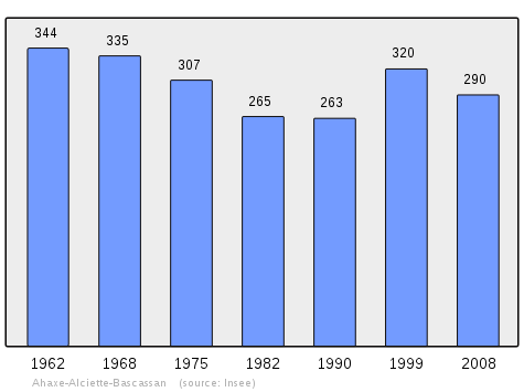
In 2010, the commune had 291 inhabitants. The evolution of the number of inhabitants is known through the population censuses conducted in the town since 1793. From the 21st century, a census of municipalities with fewer than 10,000 inhabitants is held every five years, unlike larger towns that have a sample survey every year.[Note 1][Note 2]
| 1793 | 1800 | 1806 | 1821 | 1831 | 1836 | 1841 | 1846 | 1851 |
|---|---|---|---|---|---|---|---|---|
| 474 | 485 | 472 | 460 | 555 | 588 | 930 | 864 | 892 |
| 1856 | 1861 | 1866 | 1872 | 1876 | 1881 | 1886 | 1891 | 1896 |
|---|---|---|---|---|---|---|---|---|
| 830 | 738 | 641 | 674 | 670 | 624 | 614 | 571 | 561 |
| 1901 | 1906 | 1911 | 1921 | 1926 | 1931 | 1936 | 1946 | 1954 |
|---|---|---|---|---|---|---|---|---|
| 576 | 570 | 545 | 469 | 462 | 440 | 454 | 419 | 368 |
| 1962 | 1968 | 1975 | 1982 | 1990 | 1999 | 2006 | 2007 | 2008 |
|---|---|---|---|---|---|---|---|---|
| 344 | 335 | 307 | 265 | 263 | 320 | 300 | 290 | 290 |
| 2009 | 2010 | - | - | - | - | - | - | - |
|---|---|---|---|---|---|---|---|---|
| 291 | 291 | - | - | - | - | - | - | - |
Sources : Ldh/EHESS/Cassini until 1962, INSEE database from 1968 (population without double counting and municipal population from 2006)
From 1793 to 1836 the population figures shown were only for Ahaxe as Alciette-Bascassan was still separate. Alciette-Bascassan population during that period is shown below.[31]
| 1793 | 1800 | 1806 | 1821 | 1831 | 1836 |
|---|---|---|---|---|---|
| 280 | 309 | 320 | 387 | 336 | 452 |
Economy
Economic activity is mainly agricultural. The commune is part of the zone designation of the Ossau-iraty.
The 2006 classification by INSEE, indicating the median household incomes for each municipality with more than 50 households (30,687 communes out of the 36,681 communes identified)[32] classed Ahaxe-Alciette-Bascassan at a rank of 27,645 with an average income of €13,257.
Culture and heritage
Languages
According to the Map of the Seven Basque Provinces published in 1863 by Prince Louis-Lucien Bonaparte, the Basque dialect spoken in Ahaxe-Alciette-Bascassan is eastern low Navarrese.
Civil heritage
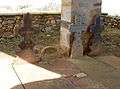
There is a gaztelu zahar (a prehistoric fortified complex) at a place called Gaztalepo (Ahaxe), located 550 metres above sea level. There is also a lice or a fence surrounding a fortification running at 313 metres above sea level at a place called Gaztelua or Gastellia. These artifacts represent the ancient past of the commune.
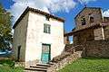
There are several buildings, houses, and farms in the commune that are listed as historical monuments. These are:
- Houses and Farms (17th - 19th centuries)
 [33]
[33] - Kapila House[34]
- Idioinea farm (17th century)[35]
- Gohonetxea farm (17th century)[6]
- Château Saint-Julien (12th century)[9]
Religious Heritage
A number of churches and sites in the commune have been classified as historical monuments. These are:
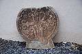
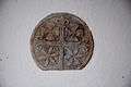
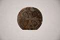
- Parish Church of Saint Julien of Antioch (16th century)[36] The cemetery contains a remarkable collection of Hilarri.
- Chapel of Saint-Saveur of Alciette (12th century).[37] The chapel contains several historical objects:
- Pulpit (17th century)
 [38]
[38] - 2 Benches (17th & 18th century)[39]
- Main Altar, Retable and 4 Candlesticks (17th century)[40]
- Secondary Altar. Retable, 2 Candlesticks (17th century)[41]
- Baptismal fonts (17th century)[42]
- Ceiling (17th century)[43]
- Statue: Baby Jesus (18th century)[44]
- Processional Cross (18th century)[45]
- Cross: Christ on the Cross (17th century)[46]
- Pulpit (17th century)
- Chapel of Saint-Saveur of Alciette (Interior Decor)[13]
- Former benoîterie of Bascassan (18th century).[47]
- Former benoîterie of Bascassan garden.[48]
- Church of Saint-André-de-Bascassan (17th century).[49] The church contains a number of historical objects. These are:
- Church of Saint-André-de-Bascassan (Interior and Cemetery)[56]
- Cemetery Cross of Ahaxe (1827)[57]
-

Church of Bascassan
-
Benoîterie
-
Old Tombs
-

Cemetery Cross of Ahaxe
-
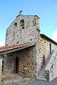
Church of Saint-Sauveur of Alciette
Facilities
The commune has a kindergarten.
See also
External links
- AHATSA-ALZIETA-BASKAZANE in the Bernardo Estornés Lasa - Auñamendi Encyclopedia (Euskomedia Fundazioa) (Spanish)
- Ahaxe-Alciette-Bascassan on Géoportail, National Geographic Institute (IGN) website (French)
- Ahaxe, Alciette, and Bascassan on the 1750 Cassini Map
- Ahaxe-Alciette-Bascassan on the INSEE website (French)
- INSEE (French)
Notes and references
Notes
- ↑ At the beginning of the 21st century, the methods of identification have been modified by law No. 2002-276 of 27 February 2002 , the so-called "law of local democracy" and in particular Title V "census operations" which allow, after a transitional period running from 2004 to 2008, the annual publication of the legal population of the different French administrative districts. For municipalities with a population greater than 10,000 inhabitants, a sample survey is conducted annually, the entire territory of these municipalities is taken into account at the end of the period of five years. The first "legal population" after 1999 under this new law came into force on 1 January 2009 and was based on the census of 2006.
- ↑ In the census table, by convention in Wikipedia, and to allow a fair comparison between five yearly censuses, the principle has been retained for subsequent legal populations since 1999 displayed in the census table that shows populations for the years 2006, 2011, 2016, etc., as well as the latest legal population published by INSEE
References
- ↑ Brigitte Jobbé-Duval, Dictionary of country names - Pyrénées-Atlantiques, 2009, Ed. Archives and Culture, ISBN 978-2-35077-151-9 (French)
- 1 2 3 4 5 6 7 8 9 10 11 12 13 14 15 16 17 18 19 20 21 22 23 24 25 26 27 28 29 Jean-Baptiste Orpustan, New Basque Toponymy, Ed. Presses universitaires de Bordeaux, 2006, ISBN 2867813964, page 140 (French)
- ↑ Google Maps
- ↑ Géoportail, IGN (French)
- 1 2 Topographic Dictionary of the Department of Basses-Pyrenees, p. 3 (French)
- 1 2 Ministry of Culture, Mérimée IA64000854 Gohonetxea Farm (French)
- 1 2 Topographic Dictionary of the Department of Basses-Pyrenees, p. 23 (French)
- 1 2 Topographic Dictionary of the Department of Basses-Pyrenees, p. 54 & 67 (French)
- 1 2 Ministry of Culture, Mérimée IA64000845 Chateau of Saint-Julien (French)
- 1 2 Topographic Dictionary of the Department of Basses-Pyrenees, p. 63 (French)
- 1 2 3 4 Topographic Dictionary of the Department of Basses-Pyrenees, p. 67 (French)
- 1 2 Topographic Dictionary of the Department of Basses-Pyrenees, p. 68 (French)
- 1 2 Ministry of Culture, Mérimée PA00084304 Chapel of Saint-Saveur Interior (French)
- 1 2 Topographic Dictionary of the Department of Basses-Pyrenees, p. 101 (French)
- 1 2 3 4 5 6 7 8 9 10 11 12 13 14 15 16 Ministry of Culture, Mérimée IA64000871 Presentation of the Commune (French)
- 1 2 3 Topographic Dictionary of the Department of Basses-Pyrenees, Paul Raymond, Imprimerie nationale, 1863, Digitised from Lyon Public Library 15 June 2011, p. 3 (French)
- 1 2 Chapter of Bayonne - Departmental Archives of Pyrénées-Atlantiques (French)
- ↑ Manuscript of the 18th century - Departmental Archives of Pyrénées-Atlantiques (French)
- ↑ Manuscripts from the 17th to the 18th centuries - Departmental Archives of des Pyrénées-Atlantiques
- 1 2 3 4 Topographic Dictionary of the Department of Basses-Pyrenees, p. 4 (French)
- 1 2 3 Titles published by don José Yanguas y Miranda (Spanish)
- 1 2 3 Derecho de naturaleza que la merindad de San-Juan-del-pie-del-puerto, una de las seys de Navarra, tiene en Castilla - 1622 petit in-4° (Spanish)
- 1 2 Topographic Dictionary of the Department of Basses-Pyrenees, p. 22 (French)
- ↑ Topographic Dictionary of the Department of Basses-Pyrenees, p. 59 (French)
- ↑ Regulations of the commandery of Irissarry - Departmental Archives of Pyrénées-Atlantiques (French)
- ↑ List of Mayors of France (French)
- ↑ Intercommunality of Pyrénées-Atlantiques, Cellule informatique préfecture 64, consulted on 9 November 2011 (French)
- ↑ Bibliothèque nationale, 6956, Moreau register 979, cited by Manex Goyhenetche, in General History of the Basque Country - Volume 3, Ed. Elkarlanean, 2001, ISBN 2913156347, page 300 (French). In the same work Manex Goyhenetche indicated (on page 284) an average number of 5.5 people per fire. (French)
- ↑ Census cited by Manex Goyhenetche in General History of the Basque Country - Volume 3, Ed. Elkarlanean, 2001, ISBN 2913156347, page 283 (French)
- ↑ Page on Alciette-Bascassan on the Cassini website of EHESS (French)
- ↑ Statistical Summary by commune, départment, and employment sector, INSEE, consulted on 9 September 2009 (French)
- ↑ Ministry of Culture, Mérimée IA64000963 Houses and Farms (French)
- ↑ Ministry of Culture, Mérimée IA64000856 Kapila House (French)
- ↑ Ministry of Culture, Mérimée IA64000855 Idioinea Farm (French)
- ↑ Ministry of Culture, Mérimée IA64000844 Church of Saint Julien (French)
- ↑ Ministry of Culture, Mérimée IA64000843 Chapel of Saint-Saveur (French)
- ↑ Ministry of Culture, Palissy PM64000015 Pulpit (French)
- ↑ Ministry of Culture, Palissy PM64000014 2 benches (French)
- ↑ Ministry of Culture, Palissy PM64000013 Main Altar, Retable and 4 Candlesticks (French)
- ↑ Ministry of Culture, Palissy PM64000012 Secondary Altar. Retable, 2 Candlesticks (French)
- ↑ Ministry of Culture, Palissy PM64000011 Baptismal fonts (French)
- ↑ Ministry of Culture, Palissy PM64000010 Ceiling (French)
- ↑ Ministry of Culture, Palissy PM64000009 Statue: Baby Jesus (French)
- ↑ Ministry of Culture, Palissy PM64000008 Processional Cross (French)
- ↑ Ministry of Culture, Palissy PM64000007 Cross: Christ on the Cross (French)
- ↑ Ministry of Culture, Mérimée IA64000851 Former benoîterie of Bascassan (French)
- ↑ Ministry of Culture, Mérimée PA00084549 Former benoîterie of Bascassan garden (French)
- ↑ Ministry of Culture, Mérimée IA64000850 Church of Saint-André-de-Bascassan (French)
- ↑ Ministry of Culture, Palissy PM64000021 2 Altars, 2 Retables, 2 Paintings, 4 Candlesticks (French)
- ↑ Ministry of Culture, Palissy PM64000020 Baptismal fonts (French)
- ↑ Ministry of Culture, Palissy PM64000019 Pulpit (French)
- ↑ Ministry of Culture, Palissy PM64000018 Processional Cross (French)
- ↑ Ministry of Culture, Palissy PM64000017 Cross: Christ on the Cross (French)
- ↑ Ministry of Culture, Palissy PM64000016 Bronze Bell (French)
- ↑ Ministry of Culture, Mérimée PA00084303 Church of Saint-André-de-Bascassan Interior & Cemetery (French)
- ↑ Ministry of Culture, Mérimée PA00084302 Cemetery Cross of Ahaxe (French)
| Wikimedia Commons has media related to Ahaxe-Alciette-Bascassan. |