Auterrive
| Auterrive | ||
|---|---|---|
|
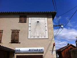
A solar clock face at Auterrive | ||
| ||
 Auterrive | ||
|
Location within Nouvelle-Aquitaine region  Auterrive | ||
| Coordinates: 43°28′02″N 0°59′51″W / 43.4672°N 0.9975°WCoordinates: 43°28′02″N 0°59′51″W / 43.4672°N 0.9975°W | ||
| Country | France | |
| Region | Nouvelle-Aquitaine | |
| Department | Pyrénées-Atlantiques | |
| Arrondissement | Pau | |
| Canton | Salies-de-Béarn | |
| Intercommunality | Salies-de-Béarn | |
| Government | ||
| • Mayor (2014–2020) | Philippe Labache | |
| Area1 | 3.08 km2 (1.19 sq mi) | |
| Population (2010)2 | 123 | |
| • Density | 40/km2 (100/sq mi) | |
| Time zone | CET (UTC+1) | |
| • Summer (DST) | CEST (UTC+2) | |
| INSEE/Postal code | 64082 / 64270 | |
| Elevation |
16–35 m (52–115 ft) (avg. 22 m or 72 ft) | |
|
1 French Land Register data, which excludes lakes, ponds, glaciers > 1 km² (0.386 sq mi or 247 acres) and river estuaries. 2 Population without double counting: residents of multiple communes (e.g., students and military personnel) only counted once. | ||
Auterrive is a French commune in the Pyrénées-Atlantiques department in the Nouvelle-Aquitaine region of south-western France.
The inhabitants of the commune are known as Auterriverains or Auterriveraines.[1]
Geography
Auterrive is located some 14 km south-east of Peyrehorade and 7 km west of Salies-de-Béarn. Access to the commune is by the D29 road from Carresse-Cassaber in the north which passes just west of the village and continues south-west to Labastide-Villefranche. Access to the village is by local roads connecting to the D29. The D28 road goes south from Saint-Dos through the west of the commune and continues to Escos in the south. The D277 goes from the D29 just west to the village west to Saint-Dos. Apart from forest along the river bank and some small forests in the west of the commune the land is all farmland.[2]
Auterrive is a Gascon village, which fully depended on Dax and is nowhere mentioned as Bearnais. Paul Raymond reported a record from 1675 when the village was referred to as Autarrive en France. Pierre-Tucoo Chala indicated a peculiarity concerning Carresse-Cassaber: the Auterrive bridge is not on the border but Gascony had a bridgehead on the right bank of the Gave d'Oloron on what is now the territory of the Béarnais village of Carresse. This area did not touch the river at the bridge and purists could say that the béarnais commune of today has incorporated a few hectares of Gascon land.
The commune is in the drainage basin of the Adour. The area east of the village is an island enclosed by a loop of the Gave d'Oloron and a stream which crosses the loop (although the Gave d'Oloron is not the border of the commune).[2]
Places and hamlets[3]
- Boucau
- Le Désert
- Dumirail[4]
- Durancou
- Labarthe
- Lahosse
- Larribère (Mill)
- Maysonnave
- Minoterie
- Noutary
- Terrenabe
Neighbouring communes and villages[2]
 |
Saint-Dos | Carresse-Cassaber | | |
| |
Salies-de-Bearn | |||
| ||||
| | ||||
| Labastide-Villefranche | Escos | Castagnède |
Toponymy
The commune name in béarnais is Autarriba. For Michel Grosclaude the origin of the name is unquestionably Gascon, auta arriba from the Latin alta ripa meaning "high river".[5]
The following table details the origins of the commune name and other names in the commune.
| Name | Spelling | Date | Source | Page | Origin | Description |
|---|---|---|---|---|---|---|
| Auterrive | Autarribe | 13th century | Raymond | Bayonne | Village | |
| Autaribe | 1360 | Raymond | Came | |||
| Sent-Miqueu d'Autarribe | 1442 | Raymond | Notaries | |||
| Autarrive en France | 1675 | Raymond | Reformation | |||
| Hauterive | 1750 | Cassini | ||||
| Dumirail | Dumirail | 1863 | Raymond | Hamlet and Lake |
Sources:
- Raymond: Topographic Dictionary of the Department of Basses-Pyrenees, 1863, on the page numbers indicated in the table. (French)[4]
- Grosclaude: Toponymic Dictionary of communes, Béarn, 2006 (French)[5]
- Cassini: Cassini Map from 1750[6]
Origins:
- Bayonne: Cartulary of Bayonne or Livre d'Or (Book of Gold)[7]
- Came: Titles of Came[8]
- Notaries: Notaries of Labastide-Villefranche[9]
- Reformation: Reformation of Béarn[10]
History
Paul Raymond noted on page 17 of his 1863 dictionary that Auterrive depended on the sub-delegation of Dax.[4]
Heraldry
.svg.png) |
Auterrive depicts a Jay in the arms to symbolize the defensive site of Barry. The Jay is reputed to give an alarm when an intruder enters a wood.
Blazon: |
Administration
List of Successive Mayors[11]
| From | To | Name | Party | Position |
|---|---|---|---|---|
| 1995 | 2014 | Josette de Caumia-Baillenx | ||
| 2014 | 2020 | Philippe Labache |
(Not all data is known)
Inter-communality
The commune is part of seven inter-communal structures:
- the Community of communes of Salies-de-Béarn;
- the SIGOM;
- the SIVU of five villages;
- the SIVU for educational regrouping of Léren, Saint-Pé-de-Léren, Saint-Dos et Auterrive;
- the Energy association of Pyrénées-Atlantiques;
- the inter-communal association for the management of drinking water from the Saleys and its gaves;
- the inter-communal association for gaves and the Saleys;
Demography
In 2010 the commune had 123 inhabitants. The evolution of the number of inhabitants is known from the population censuses conducted in the commune since 1793. From the 21st century, a census of communes with fewer than 10,000 inhabitants is held every five years, unlike larger communes that have a sample survey every year.[Note 1]
| 1793 | 1800 | 1806 | 1821 | 1831 | 1836 | 1841 | 1846 | 1851 |
|---|---|---|---|---|---|---|---|---|
| 245 | 255 | 287 | 298 | 300 | 301 | 287 | 313 | 345 |
| 1856 | 1861 | 1866 | 1872 | 1876 | 1881 | 1886 | 1891 | 1896 |
|---|---|---|---|---|---|---|---|---|
| 320 | 311 | 302 | 309 | 289 | 284 | 281 | 253 | 265 |
| 1901 | 1906 | 1911 | 1921 | 1926 | 1931 | 1936 | 1946 | 1954 |
|---|---|---|---|---|---|---|---|---|
| 240 | 230 | 248 | 200 | 202 | 205 | 212 | 226 | 201 |
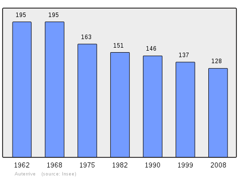
| 1962 | 1968 | 1975 | 1982 | 1990 | 1999 | 2006 | 2010 | - |
|---|---|---|---|---|---|---|---|---|
| 195 | 195 | 163 | 151 | 146 | 137 | 128 | 123 | - |
Sources : Ldh/EHESS/Cassini until 1962, INSEE database from 1968 (population without double counting and municipal population from 2006)
Economy
The commune is part of the Appellation d'origine contrôlée (AOC) zone of Ossau-iraty.
Culture and Heritage
Civil heritage
- At the foot of the Gave there is the Barry fortress which was an observation and border post between Navarre, Béarn, and Gascony. This small enclosure had a garrison of three soldiers until 1682. The currently existing ruins, although based on much older foundations, seem to date back to the Hundred Years War when Auterrive was occupied by the English and attached to the Seneschal of Hastings.
- The Maisonnabe House in the Mirails district dates to 1661;
- The Pouey House is an old manor house of justice
- The Hau House is a former dependency of the Abbey of Sorde.
There is a small enamelled plate which says "June 1875" that recalls the flood which swept away the village bridge killing two people in that year.
Religious heritage
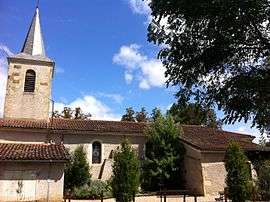
- The Church dates from the 16th century.
- There are several Calvaries including a cross of Saint-Michel which formerly marked the boundaries of the Abbey of Sorde.
- There was a Chapel in the Mirails district which was recently destroyed.
Environmental heritage
- Lake Dumirail is south-west of the commune.[2]
Amenities
There is a holiday and leisure centre at Auterrive (Les Francas).
Notable people linked to the commune
- The Marquise de Montehermoso (1784 to 1869), born Countess Maria-Pilar d'Acedo, Countess of Echauz, widow of the Marquis of the same name and mistress of Joseph Bonaparte, King of Spain, married in the village to Amédée of Carabène, the holder of numerous French and foreign decorations, future general counsel and senior officer of the Napoleonic campaigns. She was also the owner of Barry, the fortified site in the village.[12]
See also
Bibliography
- Alexis Ichas, History of Auterrive - Vols. I & II, Éditions Atlantica (French)
- Alexis Ichas, History of gaves, Éditions Atlantica (French)
- Alexis Ichas, Béarnais Chronicles of gave and the Saleys, Éditions Atlantica, 2006 (French)
External links
- Auterrive on Lion1906
- Auterrive on Google Maps
- Auterrive on Géoportail, National Geographic Institute (IGN) website (French)
- Hauterive on the 1750 Cassini Map
- Auterrive on the INSEE website (French)
- INSEE (French)
Notes and references
Notes
- ↑ At the beginning of the 21st century, the methods of identification have been modified by Law No. 2002-276 of 27 February 2002, the so-called "law of local democracy" and in particular Title V "census operations" allows, after a transitional period running from 2004 to 2008, the annual publication of the legal population of the different French administrative districts. For communes with a population greater than 10,000 inhabitants, a sample survey is conducted annually, the entire territory of these communes is taken into account at the end of the period of five years. The first "legal population" after 1999 under this new law came into force on 1 January 2009 and was based on the census of 2006.
References
- ↑ Inhabitants of Pyrénées-Atlantiques (French)
- 1 2 3 4 Google Maps
- ↑ Géoportail, IGN (French)
- 1 2 3 Topographic Dictionary of the Department of Basses-Pyrenees, Paul Raymond, Imprimerie nationale, 1863, Digitised from Lyon Public Library 15 June 2011 (French)
- 1 2 Michel Grosclaude, Toponymic Dictionary of communes, Béarn, Edicions reclams & Édition Cairn - 2006, 416 pages, ISBN 2-35068-005-3 (French)
- ↑ Cassini Map 1750 - Asson
- ↑ Manuscript from the 14th century in the Departmental Archives of Pyrénées-Atlantiques (French)
- ↑ Titles of Came in the Departmental Archives of Pyrénées-Atlantiques (French)
- ↑ Notaries of Labastide-Villefranche in the Departmental Archives of Pyrénées-Atlantiques (French)
- ↑ Manuscript from the 16th to 18th centuries - Departmental Archives of Pyrénées-Atlantiques (French)
- ↑ List of Mayors of France (French)
- ↑ Alexis Ichas, Madame de Montehermoso, Atlantica-Séguier, 2001, ISBN 978-2843943898 (French)
| Wikimedia Commons has media related to Auterrive. |