La Bastide-Clairence
| La Bastide-Clairence | ||
|---|---|---|
|
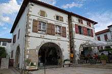
The Town Hall Square | ||
| ||
 La Bastide-Clairence | ||
|
Location within Nouvelle-Aquitaine region  La Bastide-Clairence | ||
| Coordinates: 43°25′42″N 1°15′19″W / 43.4284°N 1.2552°WCoordinates: 43°25′42″N 1°15′19″W / 43.4284°N 1.2552°W | ||
| Country | France | |
| Region | Nouvelle-Aquitaine | |
| Department | Pyrénées-Atlantiques | |
| Arrondissement | Bayonne | |
| Canton | La Bastide-Clairence | |
| Intercommunality | Pays d’Hasparren | |
| Government | ||
| • Mayor (2001–2008) | Léopold Darritchon | |
| Area1 | 23 km2 (9 sq mi) | |
| Population (2010)2 | 997 | |
| • Density | 43/km2 (110/sq mi) | |
| Time zone | CET (UTC+1) | |
| • Summer (DST) | CEST (UTC+2) | |
| INSEE/Postal code | 64289 / 64240 | |
| Elevation |
7–192 m (23–630 ft) (avg. 28 m or 92 ft) | |
|
1 French Land Register data, which excludes lakes, ponds, glaciers > 1 km² (0.386 sq mi or 247 acres) and river estuaries. 2 Population without double counting: residents of multiple communes (e.g., students and military personnel) only counted once. | ||

La Bastide-Clairence (Basque: Bastida Arberoa) is a French commune in the Pyrénées-Atlantiques department in the Nouvelle-Aquitaine region of south-western France.[1]
The inhabitants of the commune are known as Bastidots or Bastidotes.[2]
The village is a member of the Les Plus Beaux Villages de France ("The most beautiful villages of France") association.[3]
Geography
_mairie.JPG)


La Bastide-Clairence is located in the former province of Lower Navarre some 20 km east by south-east of Bayonne and 5 km north-east of Hasparren. Access to the commune is by the D10 road which branches from the D936 north of the commune and comes south to the village continuing south to join the D251 just west of Ayherre. Part of the D510 forms the western border of the commune as it goes south to join the D10 near Hasparren. The D123 goes east from the village through the length of the commune to Amorots-Succos to the south-east. The D610 connects the D510 to the D10 in the commune. The commune is mostly farmland interspersed with forest.[4][5]
La Joyeuse stream flows from the south through the village and continues north to become the Aran which joins the Adour at Urt. The Arbéroue stream flows from the south-east northwards through the eastern part of the commune to join the Lihoury north-east of the commune.[4][5]
Places and hamlets[5]
- le Bourg
- la Côte
- la Chapelle
- Pessarou
Mapping
A list of online mapping systems can be displayed by clicking on the coordinates (latitude and longitude) in the top right hand corner of this article.
Neighbouring communes and villages
 |
Briscous | Bardos | Bidache | |
| Villefranque | |
Orègue | ||
| ||||
| | ||||
| Hasparren | Ayherre | Isturits |
Toponymy
The commune name in Basque is Bastida or Bastida Arberoa[6] and in Gascon Occitan is La Bastida Clarença.
The following table details the origins of the commune name and other names in the commune.
| Name | Spelling | Date | Source | Page | Origin | Description |
|---|---|---|---|---|---|---|
| Bastide-Clairence | Bastida nueva de Clarenza | 1312 | Raymond | Camara | Village | |
| la Bastide de Clarence | 1364 | Raymond | Navarre | |||
| la Bastide | 1380 | Raymond | Duchesne | |||
| la Bastida de Clarença | 1398 | Raymond | Duchesne | |||
| La Bastide de Clarensse | 1422 | Raymond | Oloron | |||
| Bastida de Clarencia | 1513 | Raymond | Pamplona | |||
| La Bastide de Clerance | 1665 | Raymond | Register | |||
| Beata Maria de la Bastide de Clerence | 1767 | Raymond | Collations | |||
| Agnescous | Agnescous | 1863 | Raymond | Hamlet | ||
| Pessarou | Pessarrou | 1863 | Raymond | Farm |
Sources:
- Raymond: Topographic Dictionary of the Department of Basses-Pyrenees, 1863, on the page numbers indicated in the table. (French)[7]
Origins:
- Camara: Titles of the Camara of Comptos[8]
- Navarre: Titles of the Kingdom of Navarre[9]
- Duchesne: Duchesne collection volume 114[10]
- Oloron: Notaries of Oloron[11]
- Pamplona: Titles of Pamplona[12]
- Register: Register of the States of Navarre[13]
- Collations: Collations of the Diocese of Bayonne[14]
La Bastide-Clairence appears as 'LA BASTIDE Clerence on the 1750 Cassini Map[15] and as LA BASTIDE on the 1790 version.[16]
History
A Navarrese fortified village was founded in 1288 by Claire de Rabastens on a hillside next to the Aran river hence its Gascon name Bastida Clarença.
800 refugees, mainly from Bigorre, were granted a charter in July 1312 by Louis I of Navarre, the future Louis X of France. The birth of the village corresponds to a need for Navarre to create a strong town in the forested frontier area. La Bastide-Clairence, as its name suggests, was a fortified town. The historian Paul Broca could still see the remains of its ancient fortress in 1875.
La Bastide-Clairence slowly accumulated a population of shop-keepers from south-western France then from Spanish refugees fleeing the Inquisition, and also from Basque towns and villages nearby. Another version of the origin of the town exists: it was populated by settlers from diverse backgrounds including pilgrims to Santiago de Compostela called the Francos.
By 1700 the population had reached 2,000. The inhabitants lived on the nail industry, woollen garments and knitwear, and agriculture. 12-day fairs ensured the prosperity of the town. In the 16th century the locals did not speak Basque, but spoke Gascon. Subsequently they gradually adopted the Basque language and customs. The town has 320 houses and mills from the 17th century. From 1575 to 1789, La Bastide-Clairence depended on the lords of Gramont.
The city had a large Jewish community after the expulsion of Portuguese Jews in the 16th and 17th centuries.
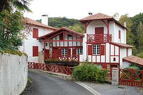
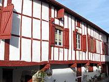
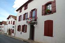
Today, the Place des Arceaux and its half-timbered houses attract many art craftsmen. The houses are very typical of the region - there are two architectural types:
- the Baserri style with gabled roofs with two slopes, half-timbered façade with red or green colour on overhangs, carved window mullions and lintels.
- the Navarrese style with roofs of 2 or 4 sides and doors with vaulted Arches.
The commune was formerly known as Labastide-Clairence and was renamed La Bastide-Clairence on 25 June 1988.
The Jewish community
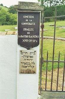
There was a Jewish community for about 200 years from the early 17th century to the end of the 18th century.
Refugees who came from Spain and especially Portugal, the Sephardi Jews, settled in Bayonne at the end of the 16th century from where they spread to the three small towns of Peyrehorade (where they were welcomed by the Lord of Aspremont), Bidache, and La Bastide-Clairence which were protected by the Duke of Gramont.
Often called "Portuguese", there were about 70-80 families in the commune in the 17th century. They lived in a relatively autonomous community designated by the expression "Jewish Nation" on the municipal records and had their own separate cemetery that was opened at the beginning of the 17th century.
The inscriptions on the tombs, numbering 62, were found from 1962 to 1964 by Professor Gérard Nahon. The oldest tomb dates from 1620 with the most recent in 1785. On 18 of them, the date of death is expressed in the Hebrew calendar. From 1659 all had biblical names: Jacob, Isaac, Benjamin, Esther, Sarah, Rebecca. Among family names there are: Dacosta, Henriquez, Lopez Nunez, Depas, Alvares.
The number of Jews decreased significantly in the middle of the 18th century when there were only 15 Jewish families. There remained only 6 in 1798.
The cemetery belongs to the Jewish Consistory of Bayonne.
Heraldry
.svg.png) |
The official status of the blazon remains to be determined.
Blazon: |
Administration
| From | To | Name | Party | Position |
|---|---|---|---|---|
| 1995 | 2014 | Léopold Darritchon | ||
| 2014 | 2020 | François Dagorret |
(Not all data is known)
Intercommunality
The town participates in nine inter-communal associations:
- the community of communes of Pays d'Hasparren Hazparneko Lurraldea;
- the AEP association of Arbéroue;
- sanitation association of Adour-Ursuia;
- the energy association of Pyrénées-Atlantiques;
- the inter-communal association for the management of the Txakurrak center;
- the inter-communal association for the industrial area of Ayherre;
- the inter-communal association for support of Basque culture;
- the joint association for studiying, developing, and monitoring the SCOT of the agglomeration of Bayonne and southern Landes;
- the association for the industrial area of Etxecolu at Bardos.
La Bastide-Clairence is the headquarters of the sanitation association of Adour-Ursuia.
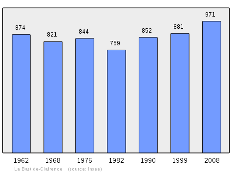
Demography
In 2010 the commune had 997 inhabitants. The evolution of the number of inhabitants is known from the population censuses conducted in the commune since 1793. From the 21st century, a census of communes with fewer than 10,000 inhabitants is held every five years, unlike larger communes that have a sample survey every year.[Note 1]
| 1793 | 1800 | 1806 | 1821 | 1831 | 1836 | 1841 | 1846 | 1851 |
|---|---|---|---|---|---|---|---|---|
| 2,071 | 1,948 | 2,043 | 2,061 | 2,003 | 2,209 | 2,097 | 2,019 | 1,836 |
| 1856 | 1861 | 1866 | 1872 | 1876 | 1881 | 1886 | 1891 | 1896 |
|---|---|---|---|---|---|---|---|---|
| 1,695 | 1,578 | 1,529 | 1,450 | 1,472 | 1,470 | 1,408 | 1,325 | 1,364 |
| 1901 | 1906 | 1911 | 1921 | 1926 | 1931 | 1936 | 1946 | 1954 |
|---|---|---|---|---|---|---|---|---|
| 1,341 | 1,333 | 1,241 | 1,054 | 1,021 | 1,101 | 1,132 | 946 | 825 |
| 1962 | 1968 | 1975 | 1982 | 1990 | 1999 | 2006 | 2010 | - |
|---|---|---|---|---|---|---|---|---|
| 874 | 821 | 844 | 759 | 852 | 881 | 990 | 997 | - |
Sources : Ldh/EHESS/Cassini until 1962, INSEE database from 1968 (population without double counting and municipal population from 2006)
Education
The commune has one private and one public primary school.[18]
Economy
Economic activity in the commune is mainly agricultural. The commune is part of the Appellation d'origine contrôlée (AOC) zone of Ossau-iraty.
Culture and heritage
_%C3%89glise_Notre-Dame-de-l'Assomption.JPG)
Civil heritage
The old Jeu de paume (1842)![]() is registered as an historical monument.[19]
is registered as an historical monument.[19]
Religious heritage
The commune has two religious sites that are registered as historical monuments:
- The Church of Notre-Dame de l'Assomption (1715)
 [20] The church contains a Painting with frame: Virgin and child (18th century)
 which is registered as an historical object.[21]
 - The old Jewish Cemetery (17th century)[22]
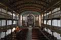 The Church interior
_painting_miracle_of_Saint_Nicholas.jpg) Painting: Virgin and child with Saint Nicholas
Painting: Virgin and child with Saint Nicholas
Notable people linked to the commune
- Joanes Leizarraga, born at Briscous in 1506 and died at Labastide-Clairence in 1601, translated the first version of the New Testament into Basque or euskara.
- Salvatus I of Iharse (or Salvat Diharce) was named by Henry III of France as Bishop of Tarbes (19 January 1577 - around 1602). He came from a branch of the family from La Bastide-Clairence[23]
- Armand Joseph Dubernad, (1741–1799), financial trader, Freemason, Consul general of the Holy Roman Empire, deputy, mayor, and co-founder of the first Jacobin Club of Brittany.
See also
Notes and references
Notes
- ↑ At the beginning of the 21st century, the methods of identification have been modified by Law No. 2002-276 of 27 February 2002, the so-called "law of local democracy" and in particular Title V "census operations" allows, after a transitional period running from 2004 to 2008, the annual publication of the legal population of the different French administrative districts. For communes with a population greater than 10,000 inhabitants, a sample survey is conducted annually and the entire territory of these communes is taken into account at the end of the period of five years. The first "legal population" after 1999 under this new law came into force on 1 January 2009 and was based on the census of 2006.
References
- ↑ bastide-clairence-.php La Bastide-Clairence on Lion1906
- ↑ Inhabitants of Pyrénées-Atlantiques (French)
- ↑ Les Plus Beaux Villages de France website
- 1 2 3 La Bastide-Clairence on Google Maps
- 1 2 3 La Bastide-Clairence on the Géoportail from National Geographic Institute (IGN) website (French)
- ↑ Euskaltzaindia - Academy of the Basque Language (French)
- ↑ Topographic Dictionary of the Department of Basses-Pyrenees, Paul Raymond, Imprimerie nationale, 1863, Digitised from Lyon Public Library 15 June 2011 (French)
- ↑ Titles published by don José Yanguas y Miranda, Diccionario de Antiguedades del reino de Navarra, 1840, Pamplona (French)
- ↑ Duchesne Collection, volume 99 to 114, containing the papers of Oihenart, former Imperial Librarian - Bibliothèque nationale de France
- ↑ Departmental Archives of Pyrénées-Atlantiques (French)
- ↑ Titles published by don José Yanguas y Miranda (Spanish)
- ↑ Manuscripts from the 17th and 18th centuries in the Departmental Archives of Pyrénées-Atlantiques (French)
- ↑ LA BASTIDE Clerence on the 1750 Cassini Map
- ↑ LA BASTIDE on the 1790 Cassini Map
- ↑ List of Mayors of France (French)
- ↑ Schools in La Bastide-Clairence (French)
- ↑ Ministry of Culture, Mérimée PA64000078 Jeu de Paume (French)
- ↑ Ministry of Culture, Mérimée PA00084416 Church of Notre-Dame de l'Assomption (French)
- ↑ Ministry of Culture, Palissy PM64000491 Painting with frame: Virgin and child (French)
- ↑ Ministry of Culture, Mérimée PA00084415 Jewish Cemetery (French)
- ↑ Armorial of Pays basque or Compendium of notices and arms of houses, families, towns, and communities of Lower Navarre, Labourd and Soule, the Valleys of Baztan, Cinco Villas, Santesteban, Erro, Aezkoa, Urrobi, Salazar and Roncal, the towns of Irún, Fontarabie, Saint-Sébastien and of the valley ..., Hubert Lamant-Duhart, H. Lamant, J & D, 1997, p.64 and 150. (French)
External links
- Official website for La Bastide-Clairence (French)
- The Bastides in Pyrénées-Atlantiques (French)
- BASTIDA ARBEROA in the Bernardo Estornés Lasa - Auñamendi Encyclopedia (Euskomedia Fundazioa) (French)
- La Bastide-Clairence, John Reps Bastides Collection, Cornell University Library
| Wikimedia Commons has media related to La Bastide-Clairence. |