Araujuzon
| Araujuzon | ||
|---|---|---|
|
Town Hall and War Memorial | ||
| ||
 Araujuzon | ||
|
Location within Nouvelle-Aquitaine region  Araujuzon | ||
| Coordinates: 43°21′39″N 0°49′03″W / 43.3608°N 0.8175°WCoordinates: 43°21′39″N 0°49′03″W / 43.3608°N 0.8175°W | ||
| Country | France | |
| Region | Nouvelle-Aquitaine | |
| Department | Pyrénées-Atlantiques | |
| Arrondissement | Oloron-Sainte-Marie | |
| Canton | Navarrenx | |
| Government | ||
| • Mayor (2008–2020) | Jean-Claude Larco | |
| Area1 | 6.92 km2 (2.67 sq mi) | |
| Population (2009)2 | 191 | |
| • Density | 28/km2 (71/sq mi) | |
| Time zone | CET (UTC+1) | |
| • Summer (DST) | CEST (UTC+2) | |
| INSEE/Postal code | 64032 / 64190 | |
| Elevation |
79–212 m (259–696 ft) (avg. 102 m or 335 ft) | |
|
1 French Land Register data, which excludes lakes, ponds, glaciers > 1 km² (0.386 sq mi or 247 acres) and river estuaries. 2 Population without double counting: residents of multiple communes (e.g., students and military personnel) only counted once. | ||

Araujuzon is a French commune in the Pyrénées-Atlantiques department in the Nouvelle-Aquitaine region of southwestern France.
The inhabitants of the commune are known as Araujuzonais or Araujuzonaises.[1][2]
Geography
Location
The town is located some 40 km north-west of Oloron-Sainte-Marie, 15 km east by south-east of Sauveterre-de-Béarn, and 8 km north-west of Navarrenx.
Access
Araujuzon is accessed by the D936 road from Oloron-Sainte-Marie which passes through the north of the commune and continues west to Autevielle-Saint-Martin-Bideren. There is also the D160 road from the southern border where it joins the D115 passing through the length of the commune to the D936 west of the village. The D265 road also links the north of the commune to Narp. The village is close to the D936 and can be reached by a number of country roads.[3]
The Intercity network of Pyrénées-Atlantiques bus network currently has a stop in the commune on Route 850 from Oloron-Sainte-Marie to Sauveterre-de-Béarn.
Hydrography
Located in the Drainage basin of the Adour, the northern border of the commune is formed by the Gave d'Oloron (a tributary of the Gave de Pau River) with its tributary, the Lausset, passing through the commune and joining the Gave d'Oleron near the village. The Ruisseau de la Mousquere rises in the commune and gathers several tributaries while flowing north-west to join the Gave d'Oleron.
The Cassou dou Boue and the Ruisseau de Lescuncette rise in the south of the commune and flow south-east to join the Ruisseau de Harcellane (a tributary of the Lausset).
Localities and hamlets
- Les Arreytes
- Les Balibes
- Beighau
- Bernatha
- Boulocq
- La Campagne
- Le Coude du Lausset
- Gaillégou
- Lacroix
- Lahagne
- Lahore
- Lamazou
- Larcebeau[4]
- Larmanou
- Lavie
- Lavoignet
- Loustalot
- Moncau
- Pessot
- Serrailh
- Souleret
- Trescassous
Neighbouring communes and villages
 |
Narp | Ossenx | Audaux | |
| Montfort | |
Araux | ||
| ||||
| | ||||
| Charre | Arrast-Larrebieu | Castetnau-Camblong |
Toponymy
The name of the commune in Béarnese is Araus-Juzon (according to classical norm of Occitan). The commune name in Gascon is Lajuson.
For Michel Grosclaude,[5] the name comes from lau ("wasteland" or "moor") and juzon ("lower" or "downstream"). Brigitte Jobbé-Duval[2] indicated that Juzon meaning "underneath" gives the place name translating as "underneath Arrau", but more likely "underneath Araux" (Araux is called Araus-Suson in Béarnese).
The following table details the origins of the commune name and other names in the commune.
| Name | Spelling | Date | Source | Page | Origin | Description |
|---|---|---|---|---|---|---|
| Araujuzon | Araus-Jusoo | 13th century | Raymond | Fors de Béarn | Village | |
| Araus-Juson | 1487 | Raymond | EStablishments | |||
| Araujuson | 1546 | Raymond | Reformation | |||
| Laujuzon | 1714 | Grosclaude | Araujuzon Parish Register | |||
| Araujuzon | 1750 | Cassini | ||||
| Araujuson | 1793 | Ldh/EHESS/Cassini | ||||
| Araujuzon | 1801 | Ldh/EHESS/Cassini | Bulletin des lois | |||
| Domec | Domec | 13th century | Raymond | Fors de Béarn | Fief, Vassal of the Viscounts of Béarn and dependent on the Bailiwick of Navarrenx | |
| Larcebeau | Le Larcebau | 1863 | Raymond | Stream also called Ruisseau d'Escounerbiets |
Sources:
- Raymond: Topographic Dictionary of the Department of Basses-Pyrenees, 1863, on the page numbers indicated in the table. (French)[4]
- Grosclaude: Toponymic Dictionary of communes, Béarn, 2006 (French)[5]
- Cassini: Cassini Map from 1750[6]
- Ldh/EHESS/Cassini: Ldh/EHESS/Cassini database (French)
Origins:
- Fors de Béarn[7]
- Establishments: Register of Establishments of Béarn[8]
- Reformation: Reformation of Béarn[9]
- Insinuations: Insinuations of the Diocese of Oloron[10]
History
Paul Raymond noted on page 8 of the 1863 dictionary that the commune had a Lay Abbey which was a vassal of the Viscounty of Béarn. In 1385 Araujuzon had 46 fires and depended on the Bailiwick of Navarrenx. It became a dependency of the Barony of Jasses from 1644 which included Araujuzon, Araux, Jasses, Montfort, and Viellenave. In 1790 the commune was part of the Canton of Sauveterre.[4]
Heraldry
.svg.png) |
Blazon: Party per fesse wavy: 1st party per pale, at 1 Or, two cows Gules horned, collared, and hooved Azure one above the other, at 2 Vert an ear of corn of Or; 2nd Azure, Saint Martin haloed mounted on a horse and cutting his cloak with his sword, all Argent. |
Administration

List of Successive Mayors[11]
| From | To | Name | Party | Position |
|---|---|---|---|---|
| 1995 | 2008 | Pierre Higue | ||
| 2008 | 2020 | Jean-Claude Larco |
(Not all data is known)
Inter-communality
The commune is part of nine inter-communal strauctures:
- the Community of communes of the Canton of Navarrenx;
- the mixed association Bil Ta Garbi;
- the mixed association of Béarn des Gaves;
- the inter-communal association of gaves and of Saleys;
- the association of Gaves Country and of Lausset;
- the association of schools of Gaveausset;
- the association for promotion of Navarrenx;
- the AEP association of Navarrenx;
- the Energy association of Pyrénées-Atlantiques.
Araujuzon is also part of the Pays de Lacq Orthez Béarn des Gaves.
Demography
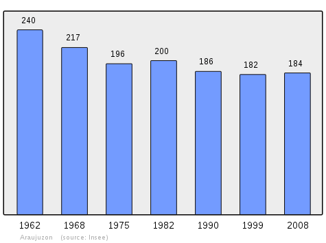
In 2009 the commune had 191 inhabitants. The evolution of the number of inhabitants is known from the population censuses conducted in the commune since 1793. From the 21st century, a census of communes with fewer than 10,000 inhabitants is held every five years, unlike larger towns that have a sample survey every year.[Note 1]
| 1793 | 1800 | 1806 | 1821 | 1831 | 1836 | 1841 | 1846 | 1851 |
|---|---|---|---|---|---|---|---|---|
| 429 | 385 | 510 | 518 | 517 | 540 | 524 | 544 | 566 |
| 1856 | 1861 | 1866 | 1872 | 1876 | 1881 | 1886 | 1891 | 1896 |
|---|---|---|---|---|---|---|---|---|
| 549 | 518 | 527 | 469 | 483 | 489 | 470 | 467 | 456 |
| 1901 | 1906 | 1911 | 1921 | 1926 | 1931 | 1936 | 1946 | 1954 |
|---|---|---|---|---|---|---|---|---|
| 428 | 417 | 403 | 327 | 301 | 302 | 301 | 298 | 268 |
| 1962 | 1968 | 1975 | 1982 | 1990 | 1999 | 2006 | 2009 | - |
|---|---|---|---|---|---|---|---|---|
| 240 | 217 | 196 | 200 | 186 | 182 | - | 191 | - |
Sources : Ldh/EHESS/Cassini until 1962, INSEE database from 1968 (population without double counting and municipal population from 2006)

Economy
Economic activity is mainly agricultural (livestock, pastures, corn). The town is part of the Appellation d'origine contrôlée (AOC) zone of Ossau-iraty.
Facilities
The commune has an elementary school.
See also
Notes
- ↑ At the beginning of the 21st century, the methods of identification have been modified by Law No. 2002-276 of 27 February 2002, the so-called "law of local democracy" and in particular Title V "census operations" allows, after a transitional period running from 2004 to 2008, the annual publication of the legal population of the different French administrative districts. For communes with a population greater than 10,000 inhabitants, a sample survey is conducted annually, the entire territory of these communes is taken into account at the end of the period of five years. The first "legal population" after 1999 under this new law came into force on 1 January 2009 and was based on the census of 2006.
References
- ↑ Inhabitants of Pyrénées-Atlantiques (French)
- 1 2 Brigitte Jobbé-Duval, Dictionary of place names - Pyrénées-Atlantiques, 2009, Archives and Culture, ISBN 978-2-35077-151-9 (French)
- ↑ Google Maps
- 1 2 3 Topographic Dictionary of the Department of Basses-Pyrenees, Paul Raymond, Imprimerie nationale, 1863, Digitised from Lyon Public Library 15 June 2011 (French)
- 1 2 Michel Grosclaude, Toponymic Dictionary of communes, Béarn, Edicions reclams & Édition Cairn - 2006, 416 pages, ISBN 2-35068-005-3 (French)
- ↑ Cassini Map 1750 – Araujuzon
- ↑ Manuscript from the 14th century - Departmental Archives of Pyrénées-Atlantiques (French)
- ↑ Manuscripts from the 15th and 16th centuries in the Departmental Archives of Pyrénées-Atlantiques (French)
- ↑ Manuscript from the 16th to 18th centuries - Departmental Archives of Pyrénées-Atlantiques (French)
- ↑ Manuscripts from the 17th century in the Departmental Archives of Pyrénées-Atlantiques (French)
- ↑ List of Mayors of France
External links
- Araujuzon official website (French)
- Araujuzon on Lion1906
- Araujuzon on the 1750 Cassini Map
- Araujuzon on the INSEE website (French)
- INSEE (French)
| Wikimedia Commons has media related to Araujuzon. |