Baleix
| Baleix | |
|---|---|
 | |
 Baleix | |
|
Location within Nouvelle-Aquitaine region  Baleix | |
| Coordinates: 43°22′45″N 0°07′43″W / 43.3792°N 0.1286°WCoordinates: 43°22′45″N 0°07′43″W / 43.3792°N 0.1286°W | |
| Country | France |
| Region | Nouvelle-Aquitaine |
| Department | Pyrénées-Atlantiques |
| Arrondissement | Pau |
| Canton | Montaner |
| Intercommunality | Luy-Gabas-Souye et Lées |
| Government | |
| • Mayor (2008–2020) | Vincent Roustaa |
| Area1 | 6.47 km2 (2.50 sq mi) |
| Population (2010)2 | 137 |
| • Density | 21/km2 (55/sq mi) |
| Time zone | CET (UTC+1) |
| • Summer (DST) | CEST (UTC+2) |
| INSEE/Postal code | 64089 / 64460 |
| Elevation |
225–354 m (738–1,161 ft) (avg. 230 m or 750 ft) |
|
1 French Land Register data, which excludes lakes, ponds, glaciers > 1 km² (0.386 sq mi or 247 acres) and river estuaries. 2 Population without double counting: residents of multiple communes (e.g., students and military personnel) only counted once. | |
Baleix is a French commune of the Pyrénées-Atlantiques department in the Nouvelle-Aquitaine region of south-western France.
The inhabitants of the commune are known as Baleichois or Baleichoises.[1]
Geography
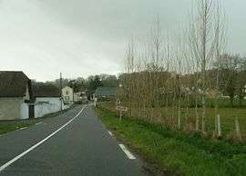
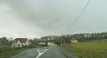
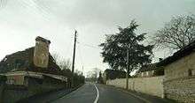
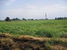
Baleix is located in the Montanérès overlooking the Lées Valley some 26 km north-east of Pau and 10 km south of Lembeye. Access to the commune is by the D7 road from Saint-Jammes in the west which passes through the length of the commune and the village and continues east to Casteide-Doat. The D145 comes from Lespourcy in the south-west and passes through the village to continue north to Anoye. Apart from the village there is also the hamlet of Tisné north-east of the village. The commune is mostly farmland with a few scattered small forests.[2]
The Lées flows through the east of the commune from the south and continues north to join the Adour near Aire-sur-l'Adour. The Petit Lées comes from the south and flows north-east through the commune to join the Lées.
Places and hamlets
Neighbouring communes and villages
 |
Abère | Anoye | Momy | |
| Saint-Laurent-Bretagne | |
Maure | ||
| ||||
| | ||||
| Lespourcy | Sedze-Maubecq | Villenave-près-Béarn |
Toponymy
Michel Grosclaude said that etymologically the name comes from the Gascon Balèch meaning "plateau".[8]
The following table details the origins of the commune name and other names in the commune.
| Name | Spelling | Date | Source | Page | Origin | Description |
|---|---|---|---|---|---|---|
| Baleix | Bales | 11th century | Raymond | Lescar | Village | |
| Balas | 12th century | Raymond | Marca | |||
| Balestoos | 13th century | Raymond | Fors de Béarn | |||
| Baleixs | 1385 | Raymond | Census | |||
| Balesie | 1402 | Raymond | Census | |||
| Baleyxs | 1538 | Raymond | Reformation | |||
| Balechs | 1538 | Raymond | Reformation | |||
| Balex | 1548 | Raymond | Reformation | |||
| Baleix | 1750 | Cassini | ||||
| Abarades | Abarades | 1863 | Raymond | Place | ||
| Abats | Abats | 1863 | Raymond | Place | ||
| Les Artics | Les Articqs | 1769 | Raymond | Terrier | Place | |
| La Bielle | La Bielle | 1863 | Raymond | Place | ||
| La Haille | Hailhe | 1769 | Raymond | Terrier | Place | |
| La Lanusse | La Lanusse | 1863 | Raymond | Place | ||
| Peyreblanque | Peyreblanque | 1863 | Raymond | Place | ||
| Le Pimi | Lou Pimy | 1769 | Raymond | Terrier | Hamlet | |
| Les Plagnius | Plagniux | 1769 | Raymond | Terrier | Place | |
| Le Plagniu | 1769 | Raymond | Terrier | |||
| Raguette | Raguet | 1769 | Raymond | Terrier | Place | |
| Trémoulets | Le Trémoulet | 1863 | Raymond | Place | ||
| Le Turocq de Naudy | Le Turocq de Naudy | 1769 | Raymond | Terrier | Place | |
| La Turrecolle | La Turequolle | 1769 | Raymond | Terrier | Place | |
| La Vignasse | La Vignasse | 1863 | Raymond | Place |
Sources:
- Raymond: Topographic Dictionary of the Department of Basses-Pyrenees, 1863, on the page numbers indicated in the table. (French)[7]
- Grosclaude: Toponymic Dictionary of communes, Béarn, 2006 (French)[8]
- Cassini: Cassini Map from 1750[9]
Origins:
- Lescar: Cartulary of Lescar[10]
- Marca: Pierre de Marca, History of Béarn.[11]
- Fors de Béarn[12]
- Census: Census of Béarn[12]
- Terrier: The Terrier of Baleix.[13]
History
Paul Raymond noted on page 20 of his 1863 dictionary that in 1385 there were 22 fires and it depended on the bailiwick of Pau. Baleix fief was subject to the Viscounts of Béarn.
The commune has long been occupied as evidenced by the discovery of a fortified camp surrounded by a moat with visible remains of earthworks.
During the medieval period the commune was a member of the Commandery of the Order of Malta of Caubin and Morlaàs.
Administration
| From | To | Name | Party | Position |
|---|---|---|---|---|
| 1995 | 2001 | Jean Balespouey | ||
| 2001 | 2008 | Gérard Balespouey | ||
| 2008 | 2020 | Vincent Roustaa |
(Not all data is known)
Inter-communality
The commune is part of four inter-communal structures:
- the Community of communes of Pays de Morlaàs;
- the SIVOM of the Canton of Montaner;
- the Energy association of Pyrénées-Atlantiques;
- the inter-communal association for the supply of drinking water Luy-Gabas-Lees;
Demography
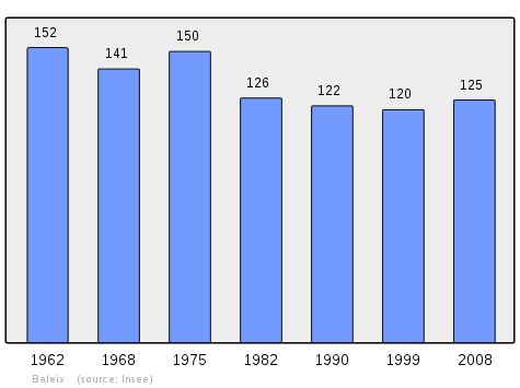
In 2010 the commune had 137 inhabitants. The evolution of the number of inhabitants is known from the population censuses conducted in the commune since 1793. From the 21st century, a census of communes with fewer than 10,000 inhabitants is held every five years, unlike larger communes that have a sample survey every year.[Note 1]
| 1793 | 1800 | 1806 | 1821 | 1831 | 1836 | 1841 | 1846 | 1851 |
|---|---|---|---|---|---|---|---|---|
| 301 | 290 | 348 | 358 | 428 | 413 | 451 | 450 | 443 |
| 1856 | 1861 | 1866 | 1872 | 1876 | 1881 | 1886 | 1891 | 1896 |
|---|---|---|---|---|---|---|---|---|
| 432 | 388 | 396 | 372 | 368 | 375 | 328 | 320 | 282 |
| 1901 | 1906 | 1911 | 1921 | 1926 | 1931 | 1936 | 1946 | 1954 |
|---|---|---|---|---|---|---|---|---|
| 280 | 270 | 251 | 202 | 201 | 194 | 176 | 158 | 156 |
| 1962 | 1968 | 1975 | 1982 | 1990 | 1999 | 2006 | 2010 | - |
|---|---|---|---|---|---|---|---|---|
| 152 | 141 | 150 | 126 | 122 | 120 | 126 | 137 | - |
Sources : Ldh/EHESS/Cassini until 1962, INSEE database from 1968 (population without double counting and municipal population from 2006)
Culture and heritage
Civil heritage
The commune has a number of buildings and structures that are registered as historical monuments:
- A Farmhouse at Sarthou (18th century)
 [6]
[6] - A House at Jean David (18th century)[5]
- A House at Castille (1623)[3]
- The Bourdallé House (18th century)[15]
- The Coulomé Farmhouse (1789)[16]
- The Bélengou House (18th century)[17]
- The Arnautou House at Clos (19th century)[4]
- Houses and Farms (17th-19th century)[18]
Religious heritage

- The Parish Church of Saint-Martin (12th century) is registered as an historical monument.[19] The Church contains a very large number of items that are registered as historical objects. For a complete list with links to descriptions (in French) click here.
See also
Bibliography
- Archaeological Map of Gaul, Archaeological pre-inventory published under the responsibility of Michel Provost, Pyrénées-Atlantiques
Notes
- ↑ At the beginning of the 21st century, the methods of identification have been modified by Law No. 2002-276 of 27 February 2002, the so-called "law of local democracy" and in particular Title V "census operations" allows, after a transitional period running from 2004 to 2008, the annual publication of the legal population of the different French administrative districts. For communes with a population greater than 10,000 inhabitants, a sample survey is conducted annually, the entire territory of these communes is taken into account at the end of the period of five years. The first "legal population" after 1999 under this new law came into force on 1 January 2009 and was based on the census of 2006.
References
- ↑ Inhabitants of Pyrénées-Atlantiques (French)
- ↑ Google Maps
- 1 2 Ministry of Culture, Mérimée IA00027133 House at Castiulle (French)
- 1 2 Ministry of Culture, Mérimée IA00027129 Arnautou House at Clos (French)

- 1 2 Ministry of Culture, Mérimée IA00027134 House at Jean David (French)
- 1 2 Ministry of Culture, Mérimée IA00027135 Farmhouse at Sarthou (French)
- 1 2 Topographic Dictionary of the Department of Basses-Pyrenees, Paul Raymond, Imprimerie nationale, 1863, Digitised from Lyon Public Library 15 June 2011 (French)
- 1 2 Michel Grosclaude, Toponymic Dictionary of communes, Béarn, Edicions reclams & Édition Cairn - 2006, 416 pages, ISBN 2-35068-005-3(French)
- ↑ Cassini Map 1750 – Baleix
- ↑ Cartulary of the Bishop of Lescar, published in the proofs of the History of Béarn by Pierre de Marca (French)
- ↑ Pierre de Marca, Histoire de Bearn, La Veuve Jean Camusat, 1640, 850 pages (French)
- 1 2 Manuscript from the 14th century - Departmental Archives of Pyrénées-Atlantiques (French)
- ↑ Manuscript from the 18th century in the Departmental Archives of Pyrénées-Atlantiques (French)
- ↑ List of Mayors of France (French)
- ↑ Ministry of Culture, Mérimée IA00027132 Bourdallé House (French)
- ↑ Ministry of Culture, Mérimée IA00027131 Coulomé Farmhouse (French)
- ↑ Ministry of Culture, Mérimée IA00027130 Bélengou House (French)
- ↑ Ministry of Culture, Mérimée IA00027127 Houses and Farms (French)
- ↑ Ministry of Culture, Mérimée IA00027128 Parish Church of Saint-Martin (French)
External links
| Wikimedia Commons has media related to Baleix. |
- Baleix on Lion1906
- Baleix on the 1750 Cassini Map
- Baleix on the INSEE website (French)
- INSEE (French)