Aussurucq
| Aussurucq | |
|---|---|
|
Dolmen in the Arbailles Forest | |
 Aussurucq | |
|
Location within Nouvelle-Aquitaine region  Aussurucq | |
| Coordinates: 43°09′01″N 0°55′57″W / 43.1503°N 0.9325°WCoordinates: 43°09′01″N 0°55′57″W / 43.1503°N 0.9325°W | |
| Country | France |
| Region | Nouvelle-Aquitaine |
| Department | Pyrénées-Atlantiques |
| Arrondissement | Oloron-Sainte-Marie |
| Canton | Mauléon-Licharre |
| Intercommunality | Soule-Xiberoa |
| Government | |
| • Mayor (2008–2020) | Jean Carricaburu |
| Area1 | 47.12 km2 (18.19 sq mi) |
| Population (2010)2 | 251 |
| • Density | 5.3/km2 (14/sq mi) |
| Time zone | CET (UTC+1) |
| • Summer (DST) | CEST (UTC+2) |
| INSEE/Postal code | 64081 / 64130 |
| Elevation |
191–1,284 m (627–4,213 ft) (avg. 209 m or 686 ft) |
|
1 French Land Register data, which excludes lakes, ponds, glaciers > 1 km² (0.386 sq mi or 247 acres) and river estuaries. 2 Population without double counting: residents of multiple communes (e.g., students and military personnel) only counted once. | |

Aussurucq (Basque: Altzürükü) is a French commune in the Pyrénées-Atlantiques department in the Nouvelle-Aquitaine region of south-western France.
The inhabitants are known as Altzürükütar.[1]
_eglise_trinitaire%2C_fa%C3%A7ade.JPG)
_vieux_st%C3%A8les_disco%C3%AFdales.JPG)
Geography
Aussurucq is located in the former province of Soule in the Massif des Arbailles some 30 km west by south-west of Oloron-Sainte-Marie and 25 km east of Saint-Jean-Pied-de-Port. Access to the commune is by road D147 from Idaux-Mendy in the north which passes through the village and continues south through the commune to join the D117 on the southern border of the commune. A pastoral road from Béhorléguy to Alçay and Aussurucq passes through the Col d'Aphanize (without crossing it) and generally follows the line of the watershed along the Col de Burdin Olatzé. The commune is mostly rugged and heavily forested however there is some farmland in the north.[2]
The Ruisseau de Guessalia rises in the south of the commune and flows north-east gathering some tributaries to join the Apouhoura north of the commune. The Arangorena forms the north-western border as it flows north-east to join the Saison near Gotein-Libarrenx. The Bidouze rises in the south of the commune and flows north to eventually join the Adour north of Bardos.[2]
Places and Hamlets[3]
- Abeheaborda
- Ahancetaborda
- Ahanzolha
- Ahusquy:[4] known for its spring of the same name
- Althabéa (ruins)
- Althabegoïty
- Ambukoborda
- Ardiaénéa
- Ascune (rocks)
- Athekaketa
- Bagadoy
- Barnexborda
- Baskinabe
- Behegayborda
- Beherégaray (barns)[4]
- Burdin-Clatze (col)
- Capara (barn)
- Carriquiborda[4]
- Chalunia
- Cumba
- Elsareko Ordokia
- Erbinia (cayolar)
- Etchakokoua
- Etchaltia (rocks)
- Etchebidea
- Etchecopar
- Etchekolaz
- Exaltia (cayolar)
- Gettaborda
- Goyheneix
- Guessalia
- Harribiribile
- Hasgagnia
- Haspia (rocks)
- Héguilloré (cayolar)
- Hidogaratia (col)
- Hidondo
- Ibarrondoa
- Ihatia
- Inharpu (col)
- Istaurdy (cayolar)
- Jaguiborda
- Jaragoyhen
- Karkatz
- Lagay
- Lapistoy[4]
- Lapitz (field)
- Larraguy
- Larramendy
- Latchéra
- Lecharegaratia (cayolar)
- Lecharéguibela (cayolar)
- Leycharzepia (fountain)
- Lhastéria
- Lohiolha
- Lucugnébehety (cayolar)
- Miadore (cayolar)
- Mouchako
- Naboleguy (cayolar)
- Nébélé (fountain)
- Nékolha[4]
- Olhatzezarre (cayolar)
- Otxolatzé (fontaine)
- Potcho (cayolars)
- Sallaberria
- Sorzauqui (col)
- Souhourtia (cayolar)
- Thartassu
- Udoya (cayolar)
- Uhalberryborda
- Uhaldéa
- Uhaltéberria
- Uhartéa
- Urrutchoya
- Urrutia (château)
- Uthurbietta (fountain)
- Uthurieta (cayolar)
- Zouhourtia
Neighbouring communes and villages[2]
 |
Saint-Just-Ibarre | Ordiarp | Idaux-Mendy | |
| Ahaxe-Alciette-Bascassan | |
Sauguis-Saint-Étienne | ||
| ||||
| | ||||
| Mendive | Lacarry-Arhan-Charritte-de-Haut | Camou-Cihigue |
Toponymy
The commune name in basque is Altzürükü.[1]
Jean-Baptiste Orpustan indicated that the name comes from the basque altzu ("alder tree") which is explained by the position of the valley covered in alder trees. The second part of the name is more enigmatic. According to Orpustan it could be from Urru ("the other side") or iri giving alzu-(i) ri-ku meaning "place in the Alder field".[5]
The following table details the origins of the commune name and other names in the commune.
| Name | Spelling | Date | Source | Page | Origin | Description |
|---|---|---|---|---|---|---|
| Aussurucq | Auçuruc | 1189 | Orpustan | Village | ||
| Auzuruc | 1337 | Orpustan | ||||
| Aussuruc | 1385 | Raymond | Duchesne | |||
| Aussuruc | 1412 | Raymond | Notaries | |||
| Ausuruc | 1454 | Raymond | Not stated | |||
| Sent-Martin d'Auçuruc, Auserucus | 1471 | Raymond | Chapter | |||
| Ausuruc | 1520 | Orpustan | ||||
| Dassurucq | 1690 | Orpustan | ||||
| Ausuruc | 1690 | Orpustan | ||||
| Aussurucq | 1690 | Orpustan | ||||
| La fontaine d'Ahusquy | La fontaine d'Ahusquy | 1863 | Raymond | Fountain | ||
| Arabéhère | Arabéhère | 1520 | Raymond | Soule | Farm | |
| Aran | Aran | 1520 | Raymond | Soule | Farm | |
| Arhanset | Arhanset | 1520 | Raymond | Soule | Farm | |
| Ariadar | Ariadar | 1520 | Raymond | Soule | Farm | |
| Arsusqui | Arsusqui | 1520 | Raymond | Soule | Farm | |
| Béherégaray | Béherégaray | 1520 | Raymond | Soule | Farm | |
| Carrica | Carrica | 1520 | Raymond | Soule | Farm | |
| Carricart | Carricart | 1520 | Raymond | Soule | Farm | |
| Carriquiri | Carriquiri | 1520 | Raymond | Soule | Farm (possibly the current Carriquiborda Farm) | |
| Goyen | Goyen | 1520 | Raymond | Soule | Farm | |
| Goyti | Goyti | 1520 | Raymond | Soule | Farm | |
| Iribarne | Iribarne | 1520 | Raymond | Soule | Farm | |
| Lapistoy | Lapitztoy | 1520 | Raymond | Soule | Farm | |
| Mendiburu | Mendiburu | 1520 | Raymond | Soule | Farm | |
| Nécol | Nécol | 1520 | Raymond | Soule | Farm (possibly the current Nékolha Farm) | |
| Sagarspe | Sagarspe | 1520 | Raymond | Soule | Farm | |
| Urruchoro | Urruchoro | 1520 | Raymond | Soule | Farm | |
| Burunolatxé | Burunolatxé | 1863 | Raymond | A Col between Alçay-Alçabéhéty-Sunharette and Aussurucq | ||
| Escuné | Escuné | 1863 | Raymond | Forest |
Sources:
- Orpustan: Jean-Baptiste Orpustan, New Basque Toponymy[5]
- Raymond: Topographic Dictionary of the Department of Basses-Pyrenees, 1863, on the page numbers indicated in the table. (French)[4]
Origins:
- Duchesne: Duchesne collection volume CXIV[6]
- Notaries: Notaries of Navarrenx[7]
- Chapter: Titles of the Chapter of Bayonne[8]
- Soule: Customs of Soule[9]
History
In the Middle Palaeolithic era Soule was already populated as remains of Neanderthal prehistoric man have been found in the Xaxixiloaga caves in Aussurucq.[10] A tumulus was also reported at shepherd's cabins in Potxo[3] along the D147 road.
The central part of Soule is also called the Messagerie des Arbailles[11] between Basabürü and Pettarra (in the Sauguis-Saint-Étienne, Aussurucq, and Barcus regions).
Administration
_La_mairie_dans_le_ch%C3%A2teau%2C_cot%C3%A9_cour.JPG)

List of Successive Mayors[12]
| From | To | Name | Party | Position |
|---|---|---|---|---|
| 1983 | 1989 | Jean Etchebarne | ||
| 1989 | 2008 | Jean-Baptiste Queheille | ||
| 2008 | 2020 | Jean Carricaburu |
(Not all data is known)
Inter-communality
The commune is part of six inter-communal structures:
- the Community of communes of Soule-Xiberoa;
- the sanitation association for Pays du Soule;
- the Energy association of Pyrénées-Atlantiques;
- the inter-communal association of Arbailla;
- the inter-communal association for transport from Musculdy to Ordiap;
- the inter-communal association to support Basque culture.
Demography
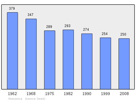
In 2010 the commune had 251 inhabitants. The evolution of the number of inhabitants is known from the population censuses conducted in the commune since 1793. From the 21st century, a census of communes with fewer than 10,000 inhabitants is held every five years, unlike larger towns that have a sample survey every year.[Note 1]
| 1793 | 1800 | 1806 | 1821 | 1831 | 1836 | 1841 | 1846 | 1851 |
|---|---|---|---|---|---|---|---|---|
| 596 | 574 | 637 | 700 | 711 | 632 | 701 | 740 | 716 |
| 1856 | 1861 | 1866 | 1872 | 1876 | 1881 | 1886 | 1891 | 1896 |
|---|---|---|---|---|---|---|---|---|
| 662 | 660 | 640 | 643 | 640 | 604 | 570 | 564 | 570 |
| 1901 | 1906 | 1911 | 1921 | 1926 | 1931 | 1936 | 1946 | 1954 |
|---|---|---|---|---|---|---|---|---|
| 523 | 512 | 518 | 472 | 502 | 459 | 437 | 432 | 401 |
| 1962 | 1968 | 1975 | 1982 | 1990 | 1999 | 2006 | 2010 | - |
|---|---|---|---|---|---|---|---|---|
| 379 | 347 | 289 | 293 | 274 | 254 | 254 | 251 | - |
Sources : Ldh/EHESS/Cassini until 1962, INSEE database from 1968 (population without double counting and municipal population from 2006)
Economy
Economic activity is based on agriculture (livestock and pasture). The commune is part of the Appellation d'origine contrôlée (AOC) zone of Ossau-iraty.
Culture and Heritage

The village features a dynamic scene related especially to Basque culture. The inhabitants of the village performed the pastoral Ürrüti Jauregiko Peirot in 2002, a play written by the son of the village Niko Etxart, an acclaimed Basque musician.
Civil heritage
- The Chateau of Ruthie (11th century)
 is registered as an historical monument.[13]
 - A Gaztelu Zahar (Castellum) is at a place called gaztelu at an altitude of 582 metres.
Religious heritage

The town has a church with a Trinitarian steeple or a tower surmounted by three points of nearly equal height.[14] The church contains a processional cross (17th century)![]() which is registered as an historical object.[15]
which is registered as an historical object.[15]
Environmental heritage
At the end of the 19th century, the Arbailles Forest covered parts of the communes of Aussurucq, Béhorléguy, Camou-Cihigue, Musculdy, Ordiarp, and Saint-Just-Ibarre.
A wealth of heritage in Aussurucq commune is contained in its sub-soil. Most of the territory of the commune is karstic. The environment is characterized by the presence of natural cavities in complex shapes that have not all yet been discovered or much less explored to date. Departmental cavers have undertaken the exploration, description, and publication of this heritage respecting the environment and the local population. One of the most beautiful caves in the commune is the Nébélé which has been the subject of works and regular explorations since 1972.
The peak of Ascune stands at 860 m, Echagorry is 935 m, Elsarré is 1,153 m, Sihigue is 1,193 m, and Etchecortia is 1,204 m.[3] In the south-west of the commune, Bohorcortia is 1,214 metres high.[3]
Amenities
The town has a primary school (Garaibie).
Notable people linked to the commune
- Pierre V de Charritte de Ruthie, born in Aussurucq, was chaplain to François I.[16]
- Gilen Epherre, born at Aussurucq in 1911 and died in Bayonne in 1974, was a writer, priest, scholar and important cultural player in the post-war period
See also
External links
- ALTZÜRUKÜ in the Bernardo Estornés Lasa - Auñamendi Encyclopedia (Euskomedia Fundazioa) (Spanish)
- Aussurucq on the Community of communes Soule-Xiberoa official website (French)
- Aussurucq on Lion1906
- Aussurucq on Google Maps
- Aussurucq on Géoportail, National Geographic Institute (IGN) website (French)
- Anßuruc on the 1750 Cassini Map
- Aussurucq on the INSEE website (French)
- INSEE (French)
Notes and references
Notes
- ↑ At the beginning of the 21st century, the methods of identification have been modified by Law No. 2002-276 of 27 February 2002, the so-called "law of local democracy" and in particular Title V "census operations" allows, after a transitional period running from 2004 to 2008, the annual publication of the legal population of the different French administrative districts. For communes with a population greater than 10,000 inhabitants, a sample survey is conducted annually, the entire territory of these communes is taken into account at the end of the period of five years. The first "legal population" after 1999 under this new law came into force on 1 January 2009 and was based on the census of 2006.
References
- 1 2 Euskaltzaindia - Academy of the Basque Language (Basque)
- 1 2 3 Google Maps
- 1 2 3 4 Géoportail, IGN (French)
- 1 2 3 4 5 6 Topographic Dictionary of the Department of Basses-Pyrenees, Paul Raymond, Imprimerie nationale, 1863, Digitised from Lyon Public Library 15 June 2011 (French)
- 1 2 Jean-Baptiste Orpustan, New Basque Toponymy, Presses universitaires de Bordeaux, 2006, ISBN 2 86781 396 4 (French)
- ↑ Duchesne Collection, volumes 99 to 114, containing the papers of Oihenart, former Imperial Librarian - Bibliothèque nationale de France
- ↑ Chapter of Bayonne in the Departmental Archives of Pyrénées-Atlantiques (French)
- ↑ Customs of Soule in 1520, printed at Pau in 1760 (French)
- ↑ See the article ' (French)
- ↑ The duty of the messenger of the royal procurer was the surveillance of a defined geographic zone - Paul Raymond, Topographic Dictionary of Béarn-basque country (French)
- ↑ List of Mayors of France (French)
- ↑ Ministry of Culture, Mérimée PA00084327 Chateau of Ruthie (French)
- ↑ Philippe Veyrin, The Basques, p. 241, Arthaud, 20 December 1975 (French)
- ↑ Ministry of Culture, Palissy PM64000061 Processional Cross (French)
- ↑ Claude de Vic, Joseph Vaissète, and Alexandre Du Mège, General History of Languedoc: with notes and justification pieces, J.B. Paya, 1841 (French)
| Wikimedia Commons has media related to Aussurucq. |