Castet
For the similarly named wine grape, see Castets (grape).
| Castet | |
|---|---|
|
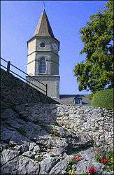
Church | |
 Castet | |
|
Location within Nouvelle-Aquitaine region  Castet | |
| Coordinates: 43°04′12″N 0°24′57″W / 43.07°N 0.4158°WCoordinates: 43°04′12″N 0°24′57″W / 43.07°N 0.4158°W | |
| Country | France |
| Region | Nouvelle-Aquitaine |
| Department | Pyrénées-Atlantiques |
| Arrondissement | Oloron-Sainte-Marie |
| Canton | Arudy |
| Intercommunality | Communauté de communes de la Vallée d'Ossau |
| Government | |
| • Mayor (2008–2014) | Robert Daguerre |
| Area1 | 23.53 km2 (9.08 sq mi) |
| Population (2006)2 | 159 |
| • Density | 6.8/km2 (18/sq mi) |
| Time zone | CET (UTC+1) |
| • Summer (DST) | CEST (UTC+2) |
| INSEE/Postal code | 64175 / 64260 |
| Elevation |
419–2,020 m (1,375–6,627 ft) (avg. 493 m or 1,617 ft) |
|
1 French Land Register data, which excludes lakes, ponds, glaciers > 1 km² (0.386 sq mi or 247 acres) and river estuaries. 2 Population without double counting: residents of multiple communes (e.g., students and military personnel) only counted once. | |
Castet is a commune in the Pyrénées-Atlantiques department in south-western France.
See also
References
| Wikimedia Commons has media related to Castet (Pyrénées-Atlantiques). |
This article is issued from Wikipedia - version of the 2/11/2016. The text is available under the Creative Commons Attribution/Share Alike but additional terms may apply for the media files.