Barraute-Camu
| Barraute-Camu | |
|---|---|
 Barraute-Camu | |
|
Location within Nouvelle-Aquitaine region  Barraute-Camu | |
| Coordinates: 43°23′19″N 0°53′42″W / 43.3886°N 0.895°WCoordinates: 43°23′19″N 0°53′42″W / 43.3886°N 0.895°W | |
| Country | France |
| Region | Nouvelle-Aquitaine |
| Department | Pyrénées-Atlantiques |
| Arrondissement | Oloron-Sainte-Marie |
| Canton | Sauveterre-de-Béarn |
| Intercommunality | Sauveterre-de-Béarn |
| Government | |
| • Mayor (1995–2020) | Jean Cazenave |
| Area1 | 3.94 km2 (1.52 sq mi) |
| Population (2010)2 | 158 |
| • Density | 40/km2 (100/sq mi) |
| Time zone | CET (UTC+1) |
| • Summer (DST) | CEST (UTC+2) |
| INSEE/Postal code | 64096 / 64390 |
| Elevation |
53–145 m (174–476 ft) (avg. 81 m or 266 ft) |
|
1 French Land Register data, which excludes lakes, ponds, glaciers > 1 km² (0.386 sq mi or 247 acres) and river estuaries. 2 Population without double counting: residents of multiple communes (e.g., students and military personnel) only counted once. | |
Barraute-Camu is a French commune of the Pyrénées-Atlantiques department in the Nouvelle-Aquitaine region of south-western France.[1]
Geography
Barraute-Camu is located 2 km east by south-east of Sauveterre-de-Béarn and 4 km west by north-west of Montfort. Access to the commune is by the D936 highway from Abitain in the west which passes through the heart of the commune just south of the village and continues east to Araujuzon. The commune is almost all farmland except for some forest along the river and along the southern border.[2][3]
The Gave d'Oloron forms the northern border of the commune as it flows west to join the Gave de Pau at Peyrehorade to become the Gaves Réunis. The Ruisseau de Lapeyrère rises in the commune and flows north to join the Gave d'Oloron.[2][3]
Places and Hamlets[3]
- La Cabé
- Camu
- Campagne de Camu
- Capulet
- Crescent
- Houch
- Lageyre
- Lahitau
- Lasbignasses
- Peyret
- Théas
Mapping
A list of online mapping systems can be displayed by clicking on the coordinates (latitude and longitude) in the top right hand corner of this article.
Neighbouring communes and villages
 |
Sauveterre-de-Béarn | Andrein | | |
| Guinarthe-Parenties | |
Laàs | ||
| ||||
| | ||||
| Saint-Gladie-Arrive-Munein | Espiute | Montfort |
Toponymy
The commune name in Occitan Gascon is Berrauta-Camun.
Michel Grosclaude said that the name comes from the basque berro: Broussailles and the collective suffix '-eta meaning "where there are no bushes" He also stated that Camu most likely comes from the Gascon kamy, the variant kamu meaning "fertile ground next to the river".[4]
The following table details the origins of the commune name and other names in the commune.
| Name | Spelling | Date | Source | Page | Origin | Description |
|---|---|---|---|---|---|---|
| Barraute | Berraute | 1150 | Grosclaude | Sord | Village | |
| Berraute | 1385 | Raymond | Census | |||
| Sent Sapriaa de Berraute | 1413 | Raymond | Notaries | |||
| Berauta | 1548 | Raymond | Reformation | |||
| Beraute | 1687 | Raymond | Reformation | |||
| Barraute | 1750 | Cassini | Cassini 1750 | |||
| Baraulte | 1801 | Ldh/EHESS/Cassini | ||||
| Barrante | 1801 | Ldh/EHESS/Cassini | ||||
| Camu | Camoo | 1385 | Raymond | Census | Village | |
| Camuu | 1385 | Raymond | Census | |||
| Camur en Bearn | 1477 | Raymond | Ohix | |||
| Les Ahitaux | Les Ahitaux | 1863 | Raymond | Hamlet |
Sources:
- Grosclaude: Toponymic Dictionary of communes, Béarn, 2006 (French)[4]
- Raymond: Topographic Dictionary of the Department of Basses-Pyrenees, 1863, on the page numbers indicated in the table. (French)[5]
- Cassini: 1750 Cassini Map[6]
- Ldh/EHESS/Cassini: Ldh/EHESS/Cassini database (French)
Origins:
- Sorde: Cartulary of Sorde[7]
- Census: Census of Béarn[8]
- Notaries: Notaries of Navarrenx[9]
- Reformation: Reformation of Béarn[10]
- Ohix: Contracts retained by Ohix, Notary of Soule[11]
History
Barraute appears as Barraute on the 1750 Cassini Map[6] and the same on the 1790 version.[12]
Camu appears as Camu on the 1750 Cassini Map[6] and does not appear on the 1790 version.[12]
Paul Raymond noted on page 21 and 40 of his 1863 dictionary that in 1385 Barraute had 24 fires and Camu 11. Barraute was part of the bailiwick of Navarrenx and Camu in that of Sauveterre.[5]
The communes of Barraute and Camu were merged on 14 June 1841.[5]
Administration
| From | To | Name | Party | Position |
|---|---|---|---|---|
| 1995 | 2020 | Jean Cazenave |
(Not all data is known)
Inter-communality
The commune is part of five inter-communal structures:
- the inter-communal centre for social action of Community of communes of Sauveterre-de-Béarn;
- the community of communes of Sauveterre-de-Béarn;
- the Energy association of Pyrénées-Atlantiques;
- the inter-communal association for management of drinking water from the Saleys and the gaves;
- the inter-communal association of gaves and Saleys
Demography
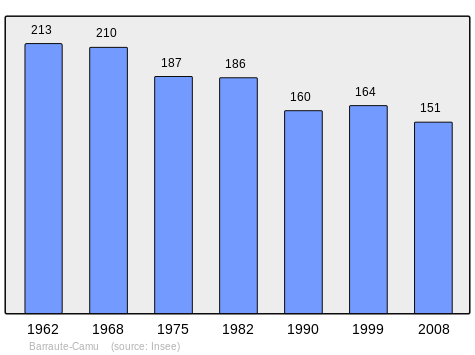
In 2010 the commune had 158 inhabitants. The evolution of the number of inhabitants is known from the population censuses conducted in the commune since 1793. From the 21st century, a census of communes with fewer than 10,000 inhabitants is held every five years, unlike larger communes that have a sample survey every year.[Note 1]
| 1793 | 1800 | 1806 | 1821 | 1831 | 1836 | 1841 | 1846 | 1851 |
|---|---|---|---|---|---|---|---|---|
| 194 | 190 | 305 | 216 | 216 | 249 | 418 | 404 | 403 |
| 1856 | 1861 | 1866 | 1872 | 1876 | 1881 | 1886 | 1891 | 1896 |
|---|---|---|---|---|---|---|---|---|
| 371 | 359 | 337 | 335 | 335 | 322 | 308 | 329 | 289 |
| 1901 | 1906 | 1911 | 1921 | 1926 | 1931 | 1936 | 1946 | 1954 |
|---|---|---|---|---|---|---|---|---|
| 304 | 318 | 294 | 258 | 256 | 271 | 246 | 245 | 222 |
| 1962 | 1968 | 1975 | 1982 | 1990 | 1999 | 2006 | 2010 | - |
|---|---|---|---|---|---|---|---|---|
| 213 | 210 | 187 | 186 | 160 | 164 | 155 | 158 | - |
Sources : Ldh/EHESS/Cassini until 1962, INSEE database from 1968 (population without double counting and municipal population from 2006)
Economy
The main activity is agricultural. The commune is part of the Appellation d'origine contrôlée of Ossau-iraty
Culture and heritage
Religious heritage
The Church of Saint Cyprien and Saint Justine (Middle Ages)![]() is registered as an historical monument.[14] It was restored in the 19th century.
is registered as an historical monument.[14] It was restored in the 19th century.
See also
Notes
- ↑ At the beginning of the 21st century, the methods of identification have been modified by Law No. 2002-276 of 27 February 2002, the so-called "law of local democracy" and in particular Title V "census operations" allows, after a transitional period running from 2004 to 2008, the annual publication of the legal population of the different French administrative districts. For communes with a population greater than 10,000 inhabitants, a sample survey is conducted annually and the entire territory of these communes is taken into account at the end of the period of five years. The first "legal population" after 1999 under this new law came into force on 1 January 2009 and was based on the census of 2006.
References
| Wikimedia Commons has media related to Barraute-Camu. |
- ↑ Barraute-Camu on Lion1906
- 1 2 3 Barraute-Camu on Google Maps
- 1 2 3 Barraute-Camu on the Géoportail from National Geographic Institute (IGN) website (French)
- 1 2 Michel Grosclaude, Toponymic Dictionary of communes, Béarn, Edicions reclams & Édition Cairn - 2006, 416 pages, ISBN 2-35068-005-3(French)
- 1 2 3 Topographic Dictionary of the Department of Basses-Pyrenees, Paul Raymond, Imprimerie nationale, 1863, Digitised from Lyon Public Library 15 June 2011 (French)
- 1 2 3 Barraute and Camu on the 1750 Cassini Map
- ↑ Cartulary of the Abbey Saint John of Sorde, published in the proofs of the History of Béarn by Pierre de Marca (French)
- ↑ Manuscript from the 14th century - Departmental Archives of Pyrénées-Atlantiques (French)
- ↑ Departmental Archives of Pyrénées-Atlantiques (French)
- ↑ Manuscript from the 16th to 18th centuries - Departmental Archives of Pyrénées-Atlantiques (French)
- ↑ Manuscripts from the 15th century in the Departmental Archives of Pyrénées-Atlantiques (French)
- 1 2 Barraute on the 1790 Cassini Map
- ↑ List of Mayors of France (French)
- ↑ Ministry of Culture, Mérimée IA64000667 Church of Saint Cyprien and Saint Justine (French)