Smithville, Missouri
| Smithville, Missouri | |
|---|---|
| City | |
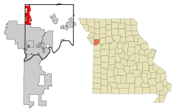 Location of Smithville, Missouri | |
| Coordinates: 39°23′12″N 94°34′36″W / 39.38667°N 94.57667°WCoordinates: 39°23′12″N 94°34′36″W / 39.38667°N 94.57667°W | |
| Country | United States |
| State | Missouri |
| Counties | Clay, Platte |
| Area[1] | |
| • Total | 15.67 sq mi (40.59 km2) |
| • Land | 15.56 sq mi (40.30 km2) |
| • Water | 0.11 sq mi (0.28 km2) |
| Elevation | 814 ft (248 m) |
| Population (2010)[2] | |
| • Total | 8,425 |
| • Estimate (2012[3]) | 8,768 |
| • Density | 541.5/sq mi (209.1/km2) |
| Time zone | Central (CST) (UTC-6) |
| • Summer (DST) | CDT (UTC-5) |
| ZIP code | 64089 |
| Area code(s) | 816 |
| FIPS code | 29-68420[4] |
| GNIS feature ID | 0730218[5] |
Smithville is a city in Clay and Platte counties in the U.S. state of Missouri, along the Little Platte River. The population was 8,425 at the 2010 United States Census.
Geography
Smithville is located at 39°23′12″N 94°34′36″W / 39.38667°N 94.57667°W (39.386620, -94.576713),[6] primarily in Clay County.
According to the United States Census Bureau, the city has a total area of 15.67 square miles (40.59 km2), of which, 15.56 square miles (40.30 km2) is land and 0.11 square miles (0.28 km2) is water.[1]
History
Smithville is named after Humphrey "Yankee" Smith (1774 – May 5, 1857) after he settled at the site in 1822.[7] The town was originally known as "Smith's Mill" but ultimately became "Smithville" as it was easier to pronounce. Another reputed history behind the name is that it was going to be named Smith's Mill, but there was already another current settlement in Missouri with the same name so it was altered slightly to differentiate it.
Silver Screen stars Wallace Beery and Noah Beery, Sr. were born and raised near Smithville. [8]
The Aker Cemetery and Downtown Smithville Historic District are listed on the National Register of Historic Places.[9][10]
Famous People
David Shannon Peterson. All state basketball, baseball from 1991-1994. School record for points (1,182) rebounds (588) and wins (68). Went on to play collegiately at Pittsburg State in Pittsburg, KS
| Historical population | |||
|---|---|---|---|
| Census | Pop. | %± | |
| 1880 | 231 | — | |
| 1890 | 372 | 61.0% | |
| 1900 | 427 | 14.8% | |
| 1910 | 680 | 59.3% | |
| 1920 | 782 | 15.0% | |
| 1930 | 902 | 15.3% | |
| 1940 | 772 | −14.4% | |
| 1950 | 947 | 22.7% | |
| 1960 | 1,254 | 32.4% | |
| 1970 | 1,785 | 42.3% | |
| 1980 | 1,873 | 4.9% | |
| 1990 | 2,525 | 34.8% | |
| 2000 | 5,514 | 118.4% | |
| 2010 | 8,425 | 52.8% | |
| Est. 2015 | 9,233 | [11] | 9.6% |
2010 census
As of the census[2] of 2010, there were 8,425 people, 3,115 households, and 2,321 families residing in the city. The population density was 541.5 inhabitants per square mile (209.1/km2). There were 3,280 housing units at an average density of 210.8 per square mile (81.4/km2). The racial makeup of the city was 96.0% White, 0.7% African American, 0.5% Native American, 0.7% Asian, 0.4% from other races, and 1.7% from two or more races. Hispanic or Latino of any race were 2.6% of the population.
There were 3,115 households of which 142.0% had children under the age of 18 living with them, 61.0% were married couples living together, 9.1% had a female householder with no husband present, 4.5% had a male householder with no wife present, and 25.5% were non-families. 21.9% of all households were made up of individuals and 8.4% had someone living alone who was 65 years of age or older. The average household size was 12.68 and the average family size was 3.13.
The median age in the city was 36.9 years. 29% of residents were under the age of 18; 5.9% were between the ages of 18 and 24; 29.3% were from 25 to 44; 25.8% were from 45 to 64; and 10.2% were 65 years of age or older. The gender makeup of the city was 49.0% male and 51.0% female.
2000 census
As of the census[4] of 2000, there were 5,514 people, 2,067 households, and 1,529 families residing in the city. The population density was 402.1 people per square mile (155.3/km²). There were 2,220 housing units at an average density of 161.9 per square mile (62.5/km²). The racial makeup of the city was 97.23% White, 0.22% African American, 0.45% Native American, 0.38% Asian, 0.11% Pacific Islander, 0.67% from other races, and 0.94% from two or more races. Hispanic or Latino of any race were 1.96% of the population.
There were 2,067 households out of which 41.0% had children under the age of 18 living with them, 62.7% were married couples living together, 8.8% had a female householder with no husband present, and 26.0% were non-families. 22.4% of all households were made up of individuals and 8.6% had someone living alone who was 65 years of age or older. The average household size was 2.62 and the average family size was 3.07.
In the city the population was spread out with 28.4% under the age of 18, 6.6% from 18 to 24, 34.3% from 25 to 44, 19.2% from 45 to 64, and 11.6% who were 65 years of age or older. The median age was 34 years. For every 100 females there were 91.7 males. For every 100 females age 18 and over, there were 89.7 males.
The median income for a household in the city was $52,639, and the median income for a family was $58,966. Males had a median income of $42,388 versus $29,150 for females. The per capita income for the city was $22,669. About 2.5% of families and 4.0% of the population were below the poverty line, including 4.0% of those under age 18 and 6.2% of those age 65 or over.
References
- 1 2 "US Gazetteer files 2010". United States Census Bureau. Retrieved 2012-07-08.
- 1 2 "American FactFinder". United States Census Bureau. Retrieved 2012-07-08.
- ↑ "Population Estimates". United States Census Bureau. Retrieved 2013-05-30.
- 1 2 "American FactFinder". United States Census Bureau. Retrieved 2008-01-31.
- ↑ "US Board on Geographic Names". United States Geological Survey. 2007-10-25. Retrieved 2008-01-31.
- ↑ "US Gazetteer files: 2010, 2000, and 1990". United States Census Bureau. 2011-02-12. Retrieved 2011-04-23.
- ↑ Eaton, David Wolfe (1916). How Missouri Counties, Towns and Streams Were Named. The State Historical Society of Missouri. p. 277.
- ↑ Dictionary of Missouri Biography, Lawrence O. Christensen, University of Missouri Press, 1999
- ↑ National Park Service (2010-07-09). "National Register Information System". National Register of Historic Places. National Park Service.
- ↑ "National Register of Historic Places Listings". Weekly List of Actions Taken on Properties: 6/16/14 through 6/27/14. National Park Service. 2014-07-03.
- ↑ "Annual Estimates of the Resident Population for Incorporated Places: April 1, 2010 to July 1, 2015". Retrieved July 2, 2016.
- ↑ "Census of Population and Housing". Census.gov. Retrieved June 4, 2015.
External links
- Historic maps of Smithville in the Sanborn Maps of Missouri Collection at the University of Missouri
Municipalities and communities of Clay County, Missouri, United States | ||
|---|---|---|
| Cities | 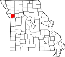 | |
| Villages | ||
| Townships |
| |
| Unincorporated communities | ||
| Footnotes | ‡This populated place also has portions in an adjacent county or counties | |
Municipalities and communities of Platte County, Missouri, United States | ||
|---|---|---|
| Cities | 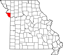 | |
| Villages | ||
| Townships |
| |
| Unincorporated communities |
| |
| Footnotes | ‡This populated place also has portions in an adjacent county or counties | |
Kansas City metropolitan area's cities and counties | ||
|---|---|---|
| Central city | 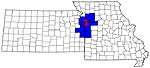 | |
| Largest cities (over 100,000 in 2000) | ||
| Medium-sized cities (10,000 to 100,000 in 2000) | ||
| Smaller Cities (between 5,000 and 9,900 in 2010) | ||
| Counties | ||