List of United States tornadoes in May 2011
This is a list of all tornadoes that were confirmed by local offices of the National Weather Service in the United States in May 2011. Following the record tornado activity in April, May 2011 exhibited an unusually low number of tornadoes for the first three weeks. Only scattered events with a small outbreak on May 11 occurred. However, activity abruptly increased with a prolonged and violent outbreak taking place from May 21 – 26, resulting in over 150 fatalities.
United States yearly total
| EF0 | EF1 | EF2 | EF3 | EF4 | EF5 | Total |
|---|---|---|---|---|---|---|
| 800 | 620 | 195 | 61 | 17 | 6 | 1699 |
May
| EF0 | EF1 | EF2 | EF3 | EF4 | EF5 | Total |
|---|---|---|---|---|---|---|
| 164 | 111 | 34 | 8 | 3 | 2 | 322 |
May 1 event
| List of reported tornadoes - Sunday, May 1, 2011 | ||||||
|---|---|---|---|---|---|---|
| | | | | | | |
| Arkansas | ||||||
| EF1 | NW of Center Ridge | Conway | Unknown | Unknown | 1 mile (1.6 km) | Brief tornado damaged several homes and outbuildings. Numerous trees were destroyed. |
| Sources: | ||||||
May 2 event
| List of reported tornadoes - Monday, May 2, 2011 | ||||||
|---|---|---|---|---|---|---|
| | | | | | | |
| Colorado | ||||||
| EF0 | SSW of Blende | Pueblo | 38°11′N 104°34′W / 38.183°N 104.567°W | 2243 | Unknown | Brief landspout with no damage |
| Sources: | ||||||
May 7 event
| List of reported tornadoes - Saturday, May 7, 2011 | ||||||
|---|---|---|---|---|---|---|
| | | | | | | |
| Illinois | ||||||
| EF0 | W of Paxton | Ford | 40°28′N 88°12′W / 40.467°N 88.200°W | 2106 | Unknown | Brief tornado with no damage |
| EF0 | SE of Allerton | Vermilion | 39°54′N 87°54′W / 39.900°N 87.900°W | 2308 | Unknown | Brief tornado with no damage |
| Sources: | ||||||
May 8 event
| List of reported tornadoes - Sunday, May 8, 2011 | ||||||
|---|---|---|---|---|---|---|
| | | | | | | |
| South Dakota | ||||||
| EF0 | SW of Presho | Lyman | 43°49′N 100°10′W / 43.817°N 100.167°W | 0103 | Unknown | Brief tornado with no damage |
| Sources: | ||||||
May 9 event
| List of reported tornadoes - Monday, May 9, 2011 | ||||||
|---|---|---|---|---|---|---|
| | | | | | | |
| Nebraska | ||||||
| EF0 | E of Harrison (1st tornado) | Sioux | 42°40′N 103°47′W / 42.667°N 103.783°W | 0035 | Unknown | Brief tornado with no damage |
| EF0 | E of Harrison (2nd tornado) | Sioux | 42°40′N 103°40′W / 42.667°N 103.667°W | 0110 | Unknown | Brief tornado with no damage |
| South Dakota | ||||||
| EF1 | NNW of Philip | Haakon | 44°08′N 101°42′W / 44.133°N 101.700°W | 0255 | 1.75 miles (2.82 km) | Plywood and metal roofing was torn off a house. A metal shed had a collapsed wall and some roof panels torn off. |
| EF0 | Ottumwa area | Haakon | 44°13′N 101°24′W / 44.217°N 101.400°W | 0345 | Unknown | Brief tornado with no damage |
| EF2 | NE of Wall | Pennington | 44°14′N 102°01′W / 44.233°N 102.017°W | 0507 | 2 miles (3.2 km) | A transmission tower was crumpled by a tornado that remained over mostly grassy areas. Several power poles were also snapped. |
| Sources: | ||||||
May 10 event
| List of reported tornadoes - Tuesday, May 10, 2011 | ||||||
|---|---|---|---|---|---|---|
| | | | | | | |
| Minnesota | ||||||
| EF1 | St. Michael area | Wright | 45°10′N 93°42′W / 45.17°N 93.70°W | 0054 | 3 miles (4.8 km) | Damage along the tornado's path was mostly EF0, though it briefly reached EF1 when it heavily damaged a garage. |
| Sources: | ||||||
May 11 event
| List of reported tornadoes - Wednesday, May 11, 2011 | ||||||
|---|---|---|---|---|---|---|
| | | | | | | |
| Nebraska | ||||||
| EF0 | SW of Ayr | Adams | 40°21′N 98°30′W / 40.350°N 98.500°W | 1840 | Unknown | Brief tornado damaged a farmstead, destroying four sheds. |
| EF1 | N of Hampton | Hamilton | 40°58′N 97°52′W / 40.967°N 97.867°W | 1950 | 3 miles (4.8 km) | An EF1 tornado overturned three irrigation pivots, destroyed two grain bins and downed seven power poles. |
| EF1 | S of Osceola | Polk | 41°09′N 97°33′W / 41.150°N 97.550°W | 2000 | 2.5 miles (4.0 km) | A few trees and a shed were damaged. |
| Texas | ||||||
| EF0 | White Settlement area | Tarrant | 32°46′N 97°27′W / 32.77°N 97.45°W | 1858 | 0.5 miles (0.80 km) | A brief tornado touched down in White Settlement, destroying a shed and damaging several homes. |
| EF0 | N of Burns | Cooke | 33°33′N 97°01′W / 33.550°N 97.017°W | 1930 | 2 miles (3.2 km) | Twenty-one homes were damaged and many trees were snapped or uprooted |
| Iowa | ||||||
| EF0 | Sharpsburg area | Taylor | 40°49′N 94°37′W / 40.817°N 94.617°W | 2120 | Unknown | Brief touchdown |
| EF1 | Lenox area (1st tornado) | Taylor | 40°52′N 94°34′W / 40.867°N 94.567°W | 2138 | 0.6 miles (0.97 km) | Diffuse tornado caused minor damage to trees and homes. |
| EF1 | Lenox area (2nd tornado) | Taylor | 40°52′N 94°34′W / 40.867°N 94.567°W | 2143 | 1.2 miles (1.9 km) | A second tornado touched down only a few blocks southwest of the first one in Lenox. Several homes sustained significant roof and facade damage, with one home losing its entire roof. |
| EF0 | ESE of Stringtown | Adams | 40°57′N 94°28′W / 40.950°N 94.467°W | 2158 | Unknown | Brief touchdown with no damage |
| EF0 | NNW of Hawarden | Sioux | 43°01′N 96°28′W / 43.017°N 96.467°W | 2311 | Unknown | Brief touchdown with no damage. |
| EF0 | SE of Ashton | Osceola | 43°18′N 95°47′W / 43.300°N 95.783°W | 0007 | 1 mile (1.6 km) | Brief touchdown with no damage. |
| Oklahoma | ||||||
| EF0 | SSE of Locust Grove | Mayes | 36°09′N 95°09′W / 36.150°N 95.150°W | 2311 | 0.5 miles (0.80 km) | Brief tornado damaged a few structures |
| EF1 | S of Bernice | Delaware | 36°36′N 94°55′W / 36.600°N 94.917°W | 2347 | 2 miles (3.2 km) | A tornado severely damaged a marina, damaged a number of boats, damaged a metal building, rolled trailers, and uprooted a number of trees. |
| Missouri | ||||||
| EF0 | ESE of Anderson | McDonald | 36°38′N 94°25′W / 36.633°N 94.417°W | 0023 | 0.75 miles (1.21 km) | A brief tornado downed a few trees and damaged a barn before lifting. |
| EF0 | SE of Papinsville | Bates | 38°04′N 94°13′W / 38.067°N 94.217°W | 0121 | 8 miles (13 km) | Landspout tornado damaged a few buildings |
| EF0 | Appleton City area | St. Clair | 38°12′N 94°02′W / 38.200°N 94.033°W | 0135 | 2.5 miles (4.0 km) | Intermittent tornado damaged a few homes |
| Sources: SPC reports for 5/11/11, NWS Hastings, NWS Twin Cities,NWS Des Moines, NWS Sioux Falls, NWS Springfield, NCDC | ||||||
May 12 event
| List of reported tornadoes - Thursday, May 12, 2011 | ||||||
|---|---|---|---|---|---|---|
| | | | | | | |
| Nebraska | ||||||
| EF0 | SW of Aurora | Hamilton | Unknown | 2146 | 0.1 miles (0.16 km) | Brief tornado with no damage. |
| EF0 | W of Stromsburg (1st tornado) | Polk | Unknown | 2333 | 0.7 miles (1.1 km) | Brief tornado with no damage that track southwestward, unusual for Nebraska tornadoes. |
| EF0 | W of Stromsburg (2nd tornado) | Polk | Unknown | 2336 | 0.1 miles (0.16 km) | Brief tornado with no damage that track southwestward, unusual for Nebraska tornadoes. |
| Sources: NWS Hastings | ||||||
May 13 event
| List of reported tornadoes - Friday, May 13, 2011 | ||||||
|---|---|---|---|---|---|---|
| | | | | | | |
| Louisiana | ||||||
| EF0 | SW of Grand Isle | Jefferson | 29°12′N 90°02′W / 29.200°N 90.033°W | 1746 | 6 miles (9.7 km) | A waterspout briefly moved onshore and tore the roof off a cabin |
| EF0 | Buras area | Plaquemines | 29°21′N 89°31′W / 29.350°N 89.517°W | 1950 | Unknown | Several waterspouts formed near Buras; however, only one moved onshore and was classified as a tornado. This storm damaged a 40 ft (12 m) section of a motel's roof. |
| Illinois | ||||||
| EF0 | ENE of McGirr | DeKalb | 41°49′N 88°46′W / 41.817°N 88.767°W | 1830 | Unknown | Brief touchdown with no damage |
| Sources: NCDC | ||||||
May 14 event
| List of reported tornadoes - Saturday, May 14, 2011 | ||||||
|---|---|---|---|---|---|---|
| | | | | | | |
| Ohio | ||||||
| EF0 | WNW of Piqua | Miami | 40°09′N 84°14′W / 40.150°N 84.233°W | 2342 | Unknown | Brief touchdown with no damage |
| EF0 | S of Sidney | Shelby | 40°15′N 84°09′W / 40.250°N 84.150°W | 0028 | Unknown | Brief touchdown with no damage |
| Sources: NCDC | ||||||
May 17 event
| List of reported tornadoes - Tuesday, May 17, 2011 | ||||||
|---|---|---|---|---|---|---|
| | | | | | | |
| Maryland | ||||||
| EF0 | NNE of Wolfsville | Frederick | 39°35′N 77°32′W / 39.59°N 77.54°W | 2135 | 1.1 miles (1.8 km) | Brief tornado damaged trees and one home |
| EF1 | S of Maugansville | Washington | 39°41′N 77°45′W / 39.68°N 77.75°W | 0010 | 2.1 miles (3.4 km) | Brief tornado touched down near Maugansville, downing large trees and damaging cars. One home also sustained minor roof damage. |
| Colorado | ||||||
| EF0 | S of Anton | Washington | 39°36′N 103°15′W / 39.600°N 103.250°W | 2345 | 2 miles (3.2 km) | Brief tornado damaged fences and power lines |
| EF0 | ESE of Anton | Washington | 39°44′N 103°12′W / 39.733°N 103.200°W | 0018 | 3 miles (4.8 km) | Short-lived tornado with no damage |
| Sources: NWS Baltimore/Washington, NCDC | ||||||
May 18 event
| List of reported tornadoes - Wednesday, May 18, 2011 | ||||||
|---|---|---|---|---|---|---|
| | | | | | | |
| Pennsylvania | ||||||
| EF0 | Northeast Philadelphia area | Philadelphia | 40°05′N 75°01′W / 40.09°N 75.02°W | 1750 | 0.2 miles (320 m) | Brief tornado touched in Northeast Philadelphia. One structure had its roof torn off and another collapsed. Two people were injured as a result of the tornado. First tornado to strike Philadelphia since January 18, 1999. |
| EF1 | Millersburg area | Dauphin | 40°32′N 76°58′W / 40.54°N 76.96°W | 2205 | 0.25 miles (400 m) | Brief tornado touched near Millersburg and removed part of a roof from a home before dissipating. |
| Colorado | ||||||
| EF0 | WSW of Haswell | Kiowa | 38°25′N 103°15′W / 38.417°N 103.250°W | 2355 | Unknown | Brief tornado with no damage |
| Sources: SPC Storm Reports for 5/18/11, NCDC | ||||||
May 19 event
| List of reported tornadoes - Thursday, May 19, 2011 | ||||||
|---|---|---|---|---|---|---|
| | | | | | | |
| Maryland | ||||||
| EF0 | Church Hill area | Queen Annes | 39°08′N 75°59′W / 39.14°N 75.98°W | 1615 | 3 miles (4.8 km) | Waterspout moved onshore and produced minor, intermittent damage. |
| Kansas | ||||||
| EF0 | SSE of Wilson Lake | Russell | 38°54′N 98°32′W / 38.900°N 98.533°W | 2148 | 4 miles (6.4 km) | Tornado damaged a sail boat |
| EF0 | NW of Dorrance | Russell | 38°52′N 98°36′W / 38.867°N 98.600°W | 2153 | 2 miles (3.2 km) | Brief tornado with minor damage |
| EF0 | ENE of Wilson Lake | Russell | 38°57′N 98°28′W / 38.950°N 98.467°W | 2215 | 1 mile (1.6 km) | Brief tornado with no damage |
| EF0 | WSW of Sylvan Grove | Lincoln | 39°00′N 98°25′W / 39.000°N 98.417°W | 2225 | 1 mile (1.6 km) | Brief tornado with no damage |
| EF0 | Natoma area | Osborne | 39°10′N 99°01′W / 39.167°N 99.017°W | 0130 | Unknown | Brief tornado caused significant damage to two farmsteads |
| Oklahoma | ||||||
| EF0 | N of Cooperton | Kiowa | 34°52′N 98°52′W / 34.867°N 98.867°W | 2150 | Unknown | Brief tornado with no damage |
| EF0 | SE of Fort Cobb | Caddo | 35°04′N 98°25′W / 35.067°N 98.417°W | 2309 | Unknown | Brief tornado with no damage |
| EF0 | W of Apache | Caddo | 34°53′N 98°24′W / 34.883°N 98.400°W | 2340 | Unknown | Brief tornado with no damage |
| Colorado | ||||||
| EF0 | E of Fountain | El Paso | 38°41′N 104°39′W / 38.68°N 104.65°W | 2223 | 0.75 miles (1.21 km) | Brief tornado destroyed a camper and damaged a home and garage. |
| Texas | ||||||
| EF0 | NE of Oklaunion | Wilbarger | 34°12′N 99°03′W / 34.200°N 99.050°W | 0034 | 1 mile (1.6 km) | Brief tornado with no damage |
| Sources: NWS Mount Holly, NWS Pueblo, NCDC | ||||||
May 20 event
| List of reported tornadoes - Friday, May 20, 2011 | ||||||
|---|---|---|---|---|---|---|
| | | | | | | |
| Arkansas | ||||||
| EF0 | NE of Baldwin | Washington | 36°01′N 94°06′W / 36.017°N 94.100°W | 1320 | 1 mile (1.6 km) | Brief tornado caused minor damage at a golf course. |
| EF0 | SW of Malvern | Hot Spring | 34°20′N 92°51′W / 34.34°N 92.85°W | 2112 | 3.2 miles (5.1 km) | Trees were blown down. Houses and an apartment complex were damaged. |
| Oklahoma | ||||||
| EF1 | S of Locust Grove | Mayes | 36°06′N 95°10′W / 36.10°N 95.17°W | 1437 | 2 miles (3.2 km) | A brief tornado damaged buildings, uprooted several fence posts, snapped large limbs and destroyed a storage shed. |
| Texas | ||||||
| EF0 | NE of Manchester | Red River | 33°51′N 95°07′W / 33.850°N 95.117°W | 2236 | 2 miles (3.2 km) | A few trees were downed. |
| EF0 | NE of Hallsville | Harrison | 32°32′N 94°31′W / 32.54°N 94.51°W | 2338 | 7 miles (11 km) | A few trees were snapped or uprooted. |
| Montana | ||||||
| EF1 | S of Terry | Prairie | 46°41′N 105°19′W / 46.68°N 105.31°W | 0227 | 500 feet (150 m) | A brief tornado destroyed a small barn and severely damaged another. Several large trees were also snapped. |
| Sources: SPC Storm Reports for 5/20/11 NWS Glasgow, NCDC | ||||||
May 21 event
| List of reported tornadoes - Saturday, May 21, 2011 | ||||||
|---|---|---|---|---|---|---|
| | | | | | | |
| Texas | ||||||
| EF0 | W of Purmela | Coryell | 31°28′N 98°03′W / 31.467°N 98.050°W | 2124 | Unknown | A brief tornado caused minor tree damage |
| EF0 | Andice area | Williamson | 30°45′50″N 97°50′10″W / 30.764°N 97.836°W | 0200 | 1.5 miles (2.4 km) | A brief tornado destroyed a carport and a deck. Several mobile homes also sustained minor damage. |
| Minnesota | ||||||
| EF0 | WSW of Hamel | Hennepin | 45°02′N 93°34′W / 45.033°N 93.567°W | 2236 | Unknown | Brief tornado touched down over an open field. |
| Kansas | ||||||
| EF0 | SW of Topeka | Shawnee | 38°58′N 95°47′W / 38.97°N 95.78°W | 2316 | 1.2 miles (1.9 km) | An outbuilding was destroyed and several trees were snapped at Washburn Rural High School. |
| EF0 | SE of Topeka | Shawnee | 39°00′N 95°39′W / 39.000°N 95.650°W | 2335 | 2 miles (3.2 km) | A trailer was blown over by an observed tornado. |
| EF0 | W of Iowa Point | Doniphan | 39°55′N 95°16′W / 39.917°N 95.267°W | 2357 | 0.25 miles (0.40 km) | Brief tornado caused minor tree damage |
| EF0 | N of Perry | Jefferson | 39°08′N 95°25′W / 39.13°N 95.42°W | 0020 | 2 miles (3.2 km) | Tornado touched down near and over Perry Lake with little damage. A tree fell on a mobile home and briefly trapped the resident. |
| EF1 | NE of Emporia | Lyon | 38°26′N 96°08′W / 38.44°N 96.13°W | 0150 | 6 miles (9.7 km) | Tornado touched down north of the Emporia State Campus, heavily damaging farm buildings and downing a chimney. |
| EF3 | Reading area | Lyon, Osage | 38°31′N 95°58′W / 38.52°N 95.96°W | 0210 | 10.3 miles (16.6 km) | 1 death - Severe damage in Reading with at least 20 houses destroyed and hundreds of other houses and businesses were damaged. At least five others were injured. |
| EF0 | ENE of Reading | Osage | 38°32′N 95°54′W / 38.533°N 95.900°W | 0220 | 1.4 miles (2.3 km) | A brief tornado touched down, causing some tree damage. |
| EF0 | ESE of Worden | Douglas | 38°45′N 95°16′W / 38.750°N 95.267°W | 0341 | Unknown | Brief tornado with no damage |
| EF1 | Quenemo | Osage, Franklin | 38°35′N 95°34′W / 38.58°N 95.56°W | 0343 | 3.8 miles (6.1 km) | Several houses were damaged and trees were snapped. |
| Oklahoma | ||||||
| EF0 | WNW of Sulphur | Murray | 34°31′N 97°00′W / 34.517°N 97.000°W | 0000 | Unknown | Brief tornado with no known damage |
| EF1 | E of Hickory | Murray, Pontotoc | 34°33′N 96°49′W / 34.550°N 96.817°W | 0039 | 8 miles (13 km) | A large multi-vortex tornado touched down over an open field. Several trees and power lines were damaged. |
| EF0 | NW of Vanoss | Pontotoc | 34°46′N 96°53′W / 34.767°N 96.883°W | 0118 | 1 mile (1.6 km) | Brief tornado with no known damage |
| EF0 | NNE of Vanoss | Pontotoc | 34°47′N 96°51′W / 34.783°N 96.850°W | 0129 | 1 mile (1.6 km) | Brief tornado with no known damage |
| EF1 | WNW of Ada | Pontotoc | 34°48′N 96°49′W / 34.800°N 96.817°W | 0141 | 3 miles (4.8 km) | A short-lived tornado damaged a few homes near Ada |
| Missouri | ||||||
| EF0 | ESE of Fillmore | Andrew | 40°00′N 95°45′W / 40.000°N 95.750°W | 0030 | 1 mile (1.6 km) | Brief tornado damaged three homes and several trees |
| Sources: NWS Topeka, NWS Austin/San Antonio | ||||||
May 22 event
| List of reported tornadoes - Sunday, May 22, 2011 | ||||||
|---|---|---|---|---|---|---|
| | | | | | | |
| Minnesota | ||||||
| EF1 | Minneapolis area | Hennepin, Anoka, Ramsey | 44°57′N 93°21′W / 44.950°N 93.350°W | 1913 | 14.25 miles (22.93 km) | 1 death – Moderate to isolated significant damage across portions of northwestern Twin Cities metropolitan area with over 100 houses and several industrial damaged and many trees and power lines were knocked down across the area. Several weaker buildings were destroyed. About 30 others were injured according to media reports. A second person died after suffering a heart attack while clearing debris in the wake of the tornado, but was not directly due to the tornado. |
| EF0 | Ham Lake area | Anoka | 45°15′N 93°09′W / 45.250°N 93.150°W | 1952 | 0.2 miles (0.32 km) | Brief tornado damaged a few trees. |
| EF0 | Forest Lake area | Washington | 45°16′N 92°56′W / 45.267°N 92.933°W | 2016 | 2.6 miles (4.2 km) | Several buildings were damaged and many trees were snapped or uprooted. |
| EF2 | La Crosse, Wisconsin area | Houston, La Crosse (WI) | 43°44′N 91°27′W / 43.733°N 91.450°W | 2100 | 14 miles (23 km) | Several houses were damaged, a few of them significantly. Barns and outbuildings were also destroyed. Numerous houses suffered significant damage and an apartment building lost its roof and upper level walls in La Crosse. Several industrial and commercial buildings were also damaged and many trees and power poles were knocked down. First tornado in La Crosse since 1966. |
| Iowa | ||||||
| EF2 | NE of Riceville to N of Harmony, MN | Howard, Fillmore (MN) | 43°24′N 92°29′W / 43.400°N 92.483°W | 1933 | 28 miles (45 km) | Long-lived tornado destroyed several outbuildings, severely damaged a farm house and damaged a few other houses and farm buildings. Widespread swath of tree damage through both counties. |
| EF2 | N of Ladora | Iowa | 41°47′N 92°12′W / 41.783°N 92.200°W | 1940 | 4 miles (6.4 km) | Multiple homes damaged, with some losing their roofs. Trees and power poles were downed. |
| EF0 | E of Millersburg | Iowa | 41°34′N 92°06′W / 41.567°N 92.100°W | 1954 | 2 miles (3.2 km) | Brief tornado flipped a shed and damaged trees. |
| EF0 | SE of Tripoli | Bremer | 42°47′N 92°13′W / 42.783°N 92.217°W | 2013 | Unknown | Brief tornado with no known damage |
| EF1 | N of Westgate | Fayette | 42°51′N 92°00′W / 42.850°N 92.000°W | 2037 | 8 miles (13 km) | Farm buildings and houses were damaged and trees were knocked down. |
| EF0 | NW of Brainard | Fayette | 42°57′N 91°43′W / 42.950°N 91.717°W | 2101 | 1 mile (1.6 km) | A house and a barn sustained minor damage and a few trees were snapped. |
| Wisconsin | ||||||
| EF1 | SW of Park Falls | Price | 45°46′37″N 90°38′42″W / 45.777°N 90.645°W | 1933 | 2.8 miles (4.5 km) | |
| EF1 | WNW of Mikana | Barron | 45°36′N 91°37′W / 45.600°N 91.617°W | 2100 | 2 miles (3.2 km) | |
| EF1 | S of Rockland | La Crosse, Monroe | 43°53′N 90°56′W / 43.883°N 90.933°W | 2147 | 9 miles (14 km) | A few trees and buildings were damaged. |
| EF2 | NW of Tomah to SE of Plover | Monroe, Juneau, Wood, Portage | 44°02′N 90°34′W / 44.033°N 90.567°W | 2215 | 69 miles (111 km) | Very long-lived but mostly weak tornado tracked through mostly wooded areas of Wisconsin, snapping or uprooting thousands of trees. Many cars and homes sustained significant damage from downed trees and the tornado itself. The tornado was on the ground for 1 hour and 31 minutes. Ranks as the 15th longest tracked tornado in Wisconsin history. |
| EF0 | W of Prentice | Price | 45°32′N 90°24′W / 45.533°N 90.400°W | 2239 | 1 mile (1.6 km) | |
| EF0 | NNW of Prentice | Price | 45°36′N 90°19′W / 45.600°N 90.317°W | 2252 | 1 mile (1.6 km) | |
| EF0 | W of Dover | Price | 45°40′N 90°15′W / 45.667°N 90.250°W | 2301 | 1.9 miles (3.1 km) | |
| EF0 | NNE of Dover | Price | 45°51′N 90°04′W / 45.850°N 90.067°W | 2326 | 0.8 miles (1.3 km) | |
| EF0 | SSW of Kingston | Green Lake | 43°39′30″N 89°11′06″W / 43.658216°N 89.185059°W | 0033 | 0.1 miles (160 m) | A garage and farm were damaged. |
| EF0 | NW of Markesan | Green Lake | 43°42′55″N 88°59′34″W / 43.715256°N 88.992648°W | 0047 | 4.7 miles (7.6 km) | Damage was confined to trees. |
| Missouri | ||||||
| EF0 | E of Lexington | Lafayette | 39°10′N 93°51′W / 39.167°N 93.850°W | 1938 | 0.1 miles (160 m) | A brief tornado destroyed an outbuilding. |
| EF0 | N of Higginsville | Lafayette | 39°05′N 93°43′W / 39.083°N 93.717°W | 2025 | 0.5 miles (0.80 km) | Brief touchdown with no damage |
| EF0 | SE of Waverly | Lafayette | 39°12′N 93°31′W / 39.200°N 93.517°W | 2058 | 0.5 miles (0.80 km) | Brief touchdown with minor damage |
| EF1 | SE of Slater | Saline | 39°13′N 93°03′W / 39.217°N 93.050°W | 2150 | 8 miles (13 km) | High-end EF1 tornado made several touchdowns along its path, destroying one house and tossing a single-wide mobile home 50 yards (46 m). |
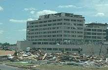
| EF5 | Joplin area | Newton, Jasper | 37°03′11″N 94°35′34″W / 37.053082°N 94.592898°W | 2234 | 22.1 miles (35.6 km) | 158 deaths – See article on this tornado |
| EF2 | Wentworth area | Newton, Lawrence | 37°00′N 94°11′W / 37.000°N 94.183°W | 2310 | 17 miles (27 km) | Several mobile homes severely damaged or destroyed. One was tossed and wrapped around a tree. Several structures in the city of Wentworth were damaged or destroyed along with numerous trees. |
| EF2 | NW of Galena | Stone, Taney | 36°49′N 93°30′W / 36.817°N 93.500°W | 0010 | 16 miles (26 km) | Several turkey barns and one mobile home were damaged while another mobile home was destroyed. Numerous trees were snapped or uprooted along most of the track. |
| Kansas | ||||||
| EF0 | WNW of Parsons | Labette | 37°19′N 95°19′W / 37.317°N 95.317°W | 2110 | Unknown | Brief touchdown over an open field |
| Indiana | ||||||
| EF1 | ENE of Rensselaer | Jasper | 40°57′N 87°09′W / 40.950°N 87.150°W | 2137 | 0.25 miles (400 m) | A few buildings sustained roof damage. |
| Texas | ||||||
| EF0 | NE of Jacksboro | Jack | 2320 | unknown | Numerous trees were downed. | |
| Illinois | ||||||
| EF1 | E of Forreston | Ogle, Winnebago | 42°07′N 89°32′W / 42.117°N 89.533°W | 2325 | 29 miles (47 km) | Numerous trees were snapped or uprooted and multiple homes sustained minor to moderate damage. |
| EF1 | SE of Polo | Ogle | 41°58′N 89°34′W / 41.967°N 89.567°W | 2328 | 1.5 miles (2.4 km) | Several farm buildings were damaged, including a grain bin which was ripped from its foundation. |
| EF1 | N of Stillman Valley | Ogle | 42°09′N 89°10′W / 42.150°N 89.167°W | 2340 | 1 mile (1,600 m) | Brief tornado damaged a power pole and several houses. |
| EF1 | NE of Wempleton | Winnebago | 42°22′N 89°10′W / 42.367°N 89.167°W | 2355 | 3 miles (4,800 m) | |
| EF1 | Rockton area | Winnebago | 42°27′N 89°00′W / 42.450°N 89.000°W | 2359 | 1 mile (1,600 m) | |
| Oklahoma | ||||||
| EF2 | SE of Cleora | Delaware | 36°33′N 94°58′W / 36.550°N 94.967°W | 2333 | 6.7 miles (10.8 km) | Several houses were severely damaged and mobile homes were destroyed. Boat docks were also destroyed and trees were uprooted along Grand Lake. |
| EF1 | ENE of Neodesha | Wagoner | 36°03′N 95°22′W / 36.050°N 95.367°W | 2342 | 4 miles (6.4 km) | |
| EF3 | WSW of Zena | Delaware, McDonald (MO) | 36°28′N 94°54′W / 36.467°N 94.900°W | 2352 | 16.5 miles (26.6 km) | A large tornado, measured at 0.88 mi (1.42 km) wide, destroyed two double-wide manufactured homes and severely damaged a permanent house. Several barns and outbuildings were also destroyed. Many other homes sustained varying degrees of damage. Additionally, hundreds of trees were snapped or uprooted. |
| EF1 | ESE of Peggs | Cherokee | 36°04′N 95°03′W / 36.067°N 95.050°W | 0027 | 3 miles (4.8 km) | |
| EF0 | ESE of Scraper | Cherokee | 36°06′N 94°53′W / 36.100°N 94.883°W | 0050 | Unknown | |
| EF1 | N of Leach | Delaware | 36°13′N 94°57′W / 36.217°N 94.950°W | 0113 | 4.7 miles (7.6 km) | Several barns were destroyed by an EF1 tornado. Many other homes were also damaged. |
| EF2 | ESE of Kansas | Adair, Delaware | 36°08′N 94°45′W / 36.133°N 94.750°W | 0114 | 4.5 miles (7.2 km) | Several barns were destroyed and homes damaged. Many trees were snapped or uprooted. |
| EF0 | NNE of Twin Oaks | Delaware | 36°13′N 94°50′W / 36.217°N 94.833°W | 0129 | 1 mile (1.6 km) | |
| EF2 | W of West Siloam Springs | Delaware | 36°10′N 94°39′W / 36.167°N 94.650°W | 0130 | 2.9 miles (4.7 km) | Six mobile homes were destroyed, injuring 12 people. Many trees were also snapped or uprooted. |
| EF1 | SSW of Moseley | Delaware | 36°13′N 94°50′W / 36.217°N 94.833°W | 0136 | 2 miles (3.2 km) | |
| EF1 | NNE of West Siloam Springs | Delaware | 36°12′N 94°35′W / 36.200°N 94.583°W | 0144 | 1 mile (1.6 km) | |
| North Dakota | ||||||
| EF0 | E of Tolley | Renville | 0141 | unknown | Tornado witnessed by law enforcement. No damage was reported. | |
| Arkansas | ||||||
| EF1 | WSW of Gentry | Benton | 36°14′N 94°31′W / 36.233°N 94.517°W | 0154 | 2.8 miles (4.5 km) | Several barns were damaged and many trees were snapped or uprooted. |
| Sources: SPC Storm Reports for 05/22/11, NWS La Crosse, NWS Springfield, NWS Quad Cities, NWS Milwaukee/Sullivan, NWS Tulsa, NWS Green Bay, NWS Twin Cities | ||||||
May 23 event
| List of reported tornadoes - Monday, May 23, 2011 | ||||||
|---|---|---|---|---|---|---|
| | | | | | | |
| Missouri | ||||||
| EF0 | E of Moody | Howell | 36°32′N 91°55′W / 36.533°N 91.917°W | 1845 | 0.6 miles (0.97 km) | An unsecured carport was thrown 150 yards (140 m) and a home was damaged. Several trees snapped. |
| EF0 | NNW of Shawneetown | Cape Girardeau | 37°34′N 89°39′W / 37.567°N 89.650°W | 2054 | 0.5 miles (0.80 km) | Brief touchdown in a rural area. Eyewitness reports indicate that there was visible debris when the tornado was on the ground. |
| Indiana | ||||||
| EF0 | N of Mt. Etna | Huntington | 40°47′N 85°34′W / 40.783°N 85.567°W | 2132 | 0.3 miles (0.48 km) | Damage was confined to trees. |
| EF0 | SE of Sunman | Ripley, Dearborn | 39°12′N 85°06′W / 39.200°N 85.100°W | 2243 | 3.08 miles (4.96 km) | A barn was destroyed, a house was damaged and many trees were snapped. |
| Pennsylvania | ||||||
| EF2 | ENE Cocolamus | Juniata | 40°39′N 77°11′W / 40.650°N 77.183°W | 2123 | 4.7 miles (7.6 km) | Numerous houses, barns and outbuildings were damaged or destroyed. |
| EF1 | Winfield area | Union, Cumberland | 40°55′N 76°51′W / 40.917°N 76.850°W | 2139 | 1.25 miles (2.01 km) | |
| EF1 | S of Brockton | Schuylkill | 40°44′N 76°03′W / 40.733°N 76.050°W | 2237 | 0.25 miles (400 m) | Brief tornado destroyed a barn and damaged two houses. |
| EF0 | Franklin Township area | Carbon | 40°50′N 75°42′W / 40.833°N 75.700°W | 2325 | 0.4 miles (0 km) | One structure sustained significant damage and numerous trees downed. One person was injured |
| Oklahoma | ||||||
| EF0 | NW of Okeene | Blaine | 36°08′N 98°20′W / 36.133°N 98.333°W | 2126 | Unknown | |
| EF0 | Fairfax area | Osage | 36°34′N 96°41′W / 36.567°N 96.683°W | 2252 | Unknown | |
| Michigan | ||||||
| EF0 | SE of McMillan Corner | Luce, Mackinac | 46°15′N 85°43′W / 46.250°N 85.717°W | 2215 | 2 miles (3.2 km) | |
| Illinois | ||||||
| EF1 | SE of Equality | Gallatin | 37°42′N 88°18′W / 37.700°N 88.300°W | 2225 | 12 miles (19 km) | Several homes and buildings sustained minor to moderate damage and dozens of trees were snapped or uprooted. Many barns and outbuildings were also destroyed. |
| Ohio | ||||||
| EF1 | SW of Ohio City | Van Wert | 40°45′N 84°41′W / 40.750°N 84.683°W | 2256 | 4 miles (6.4 km) | Initially formed as a muti-vortex tornado before merging into a single funnel. |
| EF0 | SE of Moores Fork | Clermont | 39°13′N 84°00′W / 39.217°N 84.000°W | 2343 | unknown | A wood frame metal barn was destroyed and two high-voltage towers were blown down. |
| EF1 | E of Fairborn | Greene | 39°48′N 83°57′W / 39.800°N 83.950°W | 2355 | 1 mile (0 km) | Tornado remained over Greene Country Club, downing many trees. |
| EF1 | Springfield | Clark | 39°59′N 83°45′W / 39.983°N 83.750°W | 0010 | 0.5 miles (800 m) | Several houses sustained minor damage and power poles were knocked down. |
| Tennessee | ||||||
| EF2 | NE of Dover | Stewart, Christian (KY) | 36°33′N 87°49′W / 36.550°N 87.817°W | 2342 | 30 miles (48 km) | Two people were injured by this tornado. Numerous trees were snapped or uprooted. |
| Sources: SPC Storm Reports for 05/23/11, NWS Wilmington OH, NWS State College | ||||||
May 24 event
| List of reported tornadoes - Tuesday, May 24, 2011 | ||||||
|---|---|---|---|---|---|---|
| | | | | | | |
| Kansas | ||||||
| EF0 | W of Satanta | Haskell | 37°25′N 101°04′W / 37.417°N 101.067°W | 1935 | Unknown | |
| EF0 | NNW of Ingalls Municipal Airport | Gray | 37°55′N 100°32′W / 37.917°N 100.533°W | 2034 | Unknown | |
| EF0 | SSE of Eminence | Finney | 38°01′N 100°26′W / 38.017°N 100.433°W | 2045 | Unknown | |
| EF2 | E of Seward | Stafford, Barton | 38°09′N 98°42′W / 38.150°N 98.700°W | 2252 | 12.1 miles (19.5 km) | 2 deaths – A tree blew onto a van on U.S. Route 281, killing the occupants. Severe damage reported to houses in the area. |
| EF1 | N of Ellinwood | Barton | 38°22′N 98°34′W / 38.367°N 98.567°W | 2209 | 5.2 miles (8.4 km) | Several houses were damaged. One person was injured. |
| EF1 | SSE of Timken | Rush | 38°26′N 99°09′W / 38.433°N 99.150°W | 2220 | 6.3 miles (10.1 km) | |
| EF1 | S of Timken | Rush | 38°28′N 99°09′W / 38.467°N 99.150°W | 2235 | 6.3 miles (10.1 km) | Large wedge tornado, estimated to be 1,200 yards (1,100 m) wide, remained mostly in open fields with minor damage to trees and outbuildings. Due to the lack of major damage, it is possible that the tornado was stronger than EF1. |
| EF1 | S of Rozel | Pawnee | 38°09′N 99°23′W / 38.150°N 99.383°W | 2301 | 5 miles (8.0 km) | |
| EF0 | S of Timken | Rush | 38°16′N 99°15′W / 38.267°N 99.250°W | 2327 | 1 mile (1.6 km) | |
| EF0 | E of Hoisington | Barton | 38°31′N 98°40′W / 38.517°N 98.667°W | 0011 | Unknown | |
| EF0 | NW of Claflin | Barton | 38°32′N 98°32′W / 38.533°N 98.533°W | 0022 | Unknown | |
| EF0 | NNW of Wilson | Ellsworth | 38°51′N 98°28′W / 38.850°N 98.467°W | 0050 | Unknown | |
| Colorado | ||||||
| EF0 | E of Lamar | Prowers | 38°05′N 102°31′W / 38.083°N 102.517°W | 2010 | unknown | Brief landspout tornado confirmed by the Colorado Department of Transportation which caused no damage. |
| Oklahoma | ||||||
| EF3 | W of Canton to WSW of Fairview | Dewey, Blaine, Major | 36°05′N 98°35′W / 36.08°N 98.59°W | 2020 | 13 miles (21 km) | 1 death – Half-mile wide tornado injured two people. |
| EF3 | Lookeba area | Caddo | 35°22′N 98°22′W / 35.36°N 98.36°W | 2031 | 9 miles (14 km) | Large tornado that formed from the same storm that produced the EF5 that went from Calumet to Guthrie, Oklahoma. Initial surveys had this as the same tornado, but follow up investigation of mobile radar observations and damage path surveys revealed that this was a separate tornado. |
| EF0 | SW of Fairview | Major | 36°14′N 98°30′W / 36.233°N 98.500°W | 2047 | 1 mile (1.6 km) | Brief tornado confirmed by storm spotters. |
| EF5 | ESE of Hinton to NE of Guthrie | Canadian, Kingfisher, Logan | 35°34′N 97°58′W / 35.56°N 97.96°W | 2050 | 65 miles (105 km) | 9 deaths – Long track, large wedge tornado reported according to KWTV-DT coverage. Extensive damage reported with well built houses cleanly swept from their foundation, trees debarked, and a trailer park was destroyed. Fatalities confirmed by a sheriff. El Reno Mesonet recorded wind speeds of 151 mph (241 km/h) as the tornado passed by. NWS Norman upgraded the tornado to an EF-5 on June 1st, 2011 based on University of Oklahoma Doppler On Wheels measurements. |
| EF0 | NW of Richland | Canadian | 35°37′N 97°51′W / 35.617°N 97.850°W | 2137 | 2 miles (3.2 km) | Brief satellite tornado formed near the previous tornado. Tracking counter-clockwise around the other storm, this tornado remained on the ground for a minute before dissipating. |
| EF4 | S of Chickasha to SW of Oklahoma City | Grady, McClain, Cleveland | 35°03′N 97°57′W / 35.05°N 97.95°W | 2206 | 32 miles (51 km) | 1 death – Large wedge tornado confirmed in town by KWTV coverage. Some homes and other structural damage on the west side of Blanchard. Took a path just south of the record-breaking May 3, 1999 Moore tornado. Tornado nearly attained EF5 status with peak winds estimated just below 200 mph (320 km/h). |
| EF4 | W of Bradley to W of Goldsby | Grady, McClain | 35°51′N 97°17′W / 35.85°N 97.28°W | 2226 | 23 miles (37 km) | Tornado completely destroyed a house and other nearby structures as reported by KFOR-TV helicopter with debris falling in the Norman area. Minor injuries reported. |
| EF0 | SW of Newcastle | McClain | 35°14′N 97°37′W / 35.233°N 97.617°W | 2245 | 1 mile (1.6 km) | Brief satellite tornado to the EF4 Chicasha storm. |
| EF2 | SW of Stillwater | Payne | 36°01′N 97°10′W / 36.02°N 97.17°W | 2250 | 10 miles (16 km) | Half-mile wide tornado. |
| EF1 | SE of Goldsby | McClain | 35°06′N 97°27′W / 35.100°N 97.450°W | 2302 | 0.5 miles (0.80 km) | Brief tornado damaged a barn. |
| EF1 | SSW of McLoud | Cleveland, Pottawatomie | 36°01′N 97°10′W / 36.02°N 97.17°W | 2336 | 2 miles (3.2 km) | A semi-truck was overturned on Interstate 40. Follow up investigation reduced the damage path from 4 miles to 2 miles where damage in Northeast Cleveland County was likely due to thunderstorm winds and not the tornado. One person was injured. |
| EF1 | W of Hominy | Osage | 36°24′N 96°34′W / 36.400°N 96.567°W | 2344 | 3 miles (4.8 km) | Trees were uprooted and power lines were blown down. |
| EF2 | SW of Pawhuska | Osage | 36°28′N 96°34′W / 36.467°N 96.567°W | 2349 | 17 miles (27 km) | Extensive tree damage and a house reported destroyed. |
| EF1 | NNW of Ravia | Johnston | 34°15′N 96°45′W / 34.250°N 96.750°W | 0030 | 6 miles (9.7 km) | A large 1,200 yards (1,100 m) wide tornado caused widespread tree damaged. Only a few homes were affected. |
| EF2 | Haskell area | Muskogee, Wagoner | 35°49′N 95°40′W / 35.81°N 95.67°W | 0142 | 11 miles (18 km) | A mobile home was destroyed and trees and power poles were snapped. |
| EF2 | Wagoner area | Wagoner | 35°56′N 95°22′W / 35.933°N 95.367°W | 0213 | 4 miles (6.4 km) | Tornado touched down along the southern portion of Wagoner, damaging about 12 homes. |
| EF1 | NW of Leach | Delaware | 36°13′N 95°47′W / 36.217°N 95.783°W | 0248 | 7 miles (11 km) | Tornado snapped and uprooted trees. |
| EF1 | N of Panola | Latimer | 35°00′N 95°12′W / 35.000°N 95.200°W | 0250 | >2.5 miles (4.0 km) | Numerous trees snapped or uprooted in a forested area. The full track of the tornado could not be surveyed due to inaccessibility issues. |
| EF1 | W of Row | Delaware | 36°16′N 94°45′W / 36.267°N 94.750°W | 0306 | 6 miles (9.7 km) | Numerous trees snapped or uprooted. |
| EF0 | S of Talihina | Le Flore | 34°41′N 95°02′W / 34.683°N 95.033°W | 0314 | 2 miles (3.2 km) | Tornado touched down over open country with no damage. |
| EF2 | SE of Reichert | Le Flore | 34°49′N 94°43′W / 34.817°N 94.717°W | 0344 | 12 miles (19 km) | Large wedge tornado blew a mobile home off its foundation and heavily damaged several houses. |
| EF1 | ENE of Roland | Sequoyah, Crawford (AR) | 35°26′N 94°27′W / 35.433°N 94.450°W | 0437 | 5.25 miles (8.45 km) | Many trees were knocked down, some fell on houses with structural damage. |
| Virginia | ||||||
| EF0 | Bolton area | Russell | 36°48′N 82°13′W / 36.800°N 82.217°W | 2055 | 4 miles (6.4 km) | Short-lived tornado downed several trees. |
| Texas | ||||||
| EF0 | SE of St. Jo | Montague | 33°41′N 97°31′W / 33.68°N 97.51°W | 2246 | unknown | Brief tornado touchdown with minor tree damage. |
| EF0 | NE of Nocona | Montague | 33°49′N 97°41′W / 33.82°N 97.68°W | 2340 | unknown | Brief tornado on the east side of Lake Nocona. |
| EF0 | SW of Gainesville | Cooke | 33°37′N 97°10′W / 33.61°N 97.17°W | 0034 | 2 miles (3.2 km) | Brief tornado videotaped with no damage. |
| EF0 | N of Rhome | Wise | 33°05′N 97°29′W / 33.09°N 97.48°W | 0038 | unknown | Brief tornado caused minor damage to barns. |
| EF0 | S of Reno | Parker | 32°55′N 97°36′W / 32.917°N 97.600°W | 0038 | unknown | Brief tornado touchdown. |
| EF0 | SE of Azle | Tarrant | 32°54′N 97°34′W / 32.90°N 97.56°W | 0045 | 2 miles (3.2 km) | Tornado observed over Eagle Mountain Lake with minor damage near the shore. |
| EF2 | Denton | Denton | 33°09′N 97°04′W / 33.15°N 97.07°W | 0103 | 2 miles (3.2 km) | Significant damage to numerous houses and businesses. |
| EF1 | Irving | Dallas | 32°49′N 96°55′W / 32.82°N 96.92°W | 0123 | 0.5 miles (800 m) | An apartment building and four houses sustained roof damage. Tornado embedded in larger field of straight-line wind damage where one person was killed from the downburst. |
| EF0 | SW of Balch Springs | Dallas | 32°40′N 96°42′W / 32.66°N 96.70°W | 0248 | unknown | Tornado confirmed along Interstate 20. |
| EF0 | W of Cedarvale | Kaufman | 32°35′N 96°07′W / 32.58°N 96.12°W | 0343 | unknown | Brief tornado touchdown with minor tree damage. |
| Arkansas | ||||||
| EF4 | Denning area | Franklin, Logan Johnson | 35°16′N 93°57′W / 35.267°N 93.950°W | 0453 | 47 miles (76 km) | 4 deaths – Intense tornado up to a mile wide reported with severe damage in the area and most houses in the village destroyed. Damage was also reported in several neighboring communities. Twenty-seven people were injured. |
| EF3 | Clarksville area | Johnson, Pope | 35°25′N 93°31′W / 35.417°N 93.517°W | 0525 | 29 miles (47 km) | 1 death – Numerous houses were damaged or destroyed. Extensive tree damage along the path. |
| Sources: SPC Storm Reports for 05/24/11, NWS Wichita, NWS Norman, NWS Tulsa NWS Dodge City, NWS Little Rock | ||||||
May 25 event
| List of reported tornadoes - Wednesday, May 25, 2011 | ||||||
|---|---|---|---|---|---|---|
| | Parish | | | | | |
| Missouri | ||||||
| EF1 | E of Dogwood | Douglas, Webster | 37°01′N 92°50′W / 37.017°N 92.833°W | 0630 | 10 miles (16 km) | Several outbuildings were destroyed and numerous trees were snapped. |
| EF0 | SE of Harrisonville | Cass | 38°37′N 94°18′W / 38.617°N 94.300°W | 1635 | Unknown | Tornado confirmed by law enforcement. |
| EF2 | Sedalia area | Pettis | 38°42′N 93°14′W / 38.70°N 93.23°W | 1722 | 2 miles (3.2 km) | Two mobile home parks were largely destroyed and several permanent structures sustained heavy damage. Twenty people sustained minor injuries and losses reached $4 million |
| EF0 | W of Liberty | Clay | 39°15′N 94°26′W / 39.250°N 94.433°W | 1733 | Unknown | Brief tornado touchdown. |
| EF0 | WNW of Kearney | Clay | 39°22′N 94°23′W / 39.37°N 94.38°W | 1745 | Unknown | Brief tornado touchdown. |
| EF0 | NE of Beaman | Pettis | 38°46′N 93°07′W / 38.767°N 93.117°W | 1752 | Unknown | Brief tornado touchdown. |
| EF0 | NW of Pleasant Green | Cooper | 38°50′N 93°02′W / 38.833°N 93.033°W | 1804 | Unknown | Brief tornado touchdown. |
| EF0 | SSW of Higginsville | Lafayette | 39°03′N 93°44′W / 39.050°N 93.733°W | 1807 | Unknown | Brief tornado touchdown. |
| EF1 | NW of New Florence | Montgomery | 38°56′N 91°28′W / 38.933°N 91.467°W | 1915 | 7 miles (11 km) | Significant structural damage to houses reported. |
| EF1 | N of Myrtle | Oregon | 36°33′N 91°16′W / 36.55°N 91.27°W | 1956 | 2.5 miles (4.0 km) | Several trees were snapped or uprooted and three outbuildings sustained minor roof damage. |
| EF3 | SW of Grandin to NW of Buckhorn | Carter, Wayne, Madison | 36°56′N 90°45′W / 36.93°N 90.75°W | 2049 | 47.4 miles (76.3 km) | Large and long-lived tornado destroyed four homes, two mobile homes and several trailers, including a log cabin which was leveled. A school sustained major damage and lost its entire roof. Hundreds of acres of large trees were snapped or uprooted. At its widest, the tornado reached a diameter of 1 mile (1.6 km). |
| EF1 | Fredericktown area | Madison | 37°30′N 90°20′W / 37.50°N 90.33°W | 2135 | 5.5 miles (8.9 km) | Numerous trees were snapped or uprooted and several structures were damaged. |
| EF1 | S of Mill Spring | Wayne | 37°03′N 90°42′W / 37.050°N 90.700°W | 2137 | 17.5 miles (28.2 km) | Tornado made several touchdowns along a 17.5 mi (28.2 km) path. Two outbuildings and a small personal bridge were destroyed and numerous trees were snapped or uprooted. |
| EF0 | W of Hunter | Carter | 36°52′N 90°54′W / 36.867°N 90.900°W | 2144 | 0.25 miles (400 m) | A few tree limbs were snapped. |
| EF1 | SSE of Zion (1st tornado) | Madison | 37°21′N 90°22′W / 37.350°N 90.367°W | 2146 | 5 miles (8.0 km) | Numerous trees were snapped or uprooted |
| EF1 | SSE of Zion (2nd tornado) | Madison | 37°23′N 90°18′W / 37.383°N 90.300°W | 2147 | 4 miles (6.4 km) | Numerous trees were snapped or uprooted |
| EF0 | WNW of Yount | Perry | 37°38′N 90°06′W / 37.633°N 90.100°W | 2151 | Unknown | Several tree limbs were snapped |
| EF0 | W of Torch | Ripley | 36°31′N 90°42′W / 36.517°N 90.700°W | 2158 | 1 mile (1.6 km) | Brief tornado with no known damage |
| EF0 | W of Poplar Bluff | Butler | 36°45′N 90°26′W / 36.750°N 90.433°W | 2214 | 1 mile (1.6 km) | Brief tornado with no known damage |
| EF1 | S of Marquand | Madison, Bollinger | 37°24′N 90°10′W / 37.400°N 90.167°W | 2227 | 13 miles (21 km) | Hundreds of trees were snapped or uprooted. |
| EF1 | NW of Neeley's Landing | Cape Girardeau | 37°31′N 89°32′W / 37.517°N 89.533°W | 2318 | 2.3 miles (3.7 km) | One home sustained roofing damage and many trees were snapped or uprooted. |
| EF0 | SE of Benton | Scott | 37°04′N 89°32′W / 37.067°N 89.533°W | 2340 | 0.5 miles (800 m) | A few tree limbs were snapped. |
| Illinois | ||||||
| EF1 | ENE of Decatur | Macon | 39°53′N 88°50′W / 39.89°N 88.83°W | 1235 | 1 mile (1.6 km) | Two outbuildings and two grain bins were damaged. |
| EF1 | ENE of Oakley | Macon | 39°52′N 88°46′W / 39.87°N 88.76°W | 1239 | 1.5 miles (2.4 km) | An outbuilding was destroyed. |
| EF1 | St. Anne area | Kankakee | 41°01′N 87°43′W / 41.02°N 87.72°W | 1404 | 6 miles (9.7 km) | Several houses were damaged, along with trees and power poles. |
| EF0 | E of Heyworth | McLean | 40°19′N 88°54′W / 40.31°N 88.90°W | 2306 | 1 mile (1.6 km) | A grain bin was damaged. |
| EF1 | SE of Downs | McLean | 40°27′N 88°48′W / 40.45°N 88.80°W | 2309 | 10 miles (16 km) | A semi-truck was overturned on Interstate 74. |
| EF2 | WNW of Woodlawn | Jefferson | 38°21′N 89°07′W / 38.350°N 89.117°W | 2328 | 13 miles (21 km) | A total of 101 homes were damaged by the tornado, 23 of which were deemed uninhabitable. |
| EF1 | NNE of Anna | Union | 37°28′N 89°14′W / 37.467°N 89.233°W | 2339 | 2.25 miles (3.62 km) | A couple of homes sustained minor roof damage and numerous trees were snapped or uprooted. |
| EF1 | Mound City area | Pulaski | 37°04′N 89°10′W / 37.067°N 89.167°W | 2340 | 6 miles (9.7 km) | A mobile home was tossed into a power pole and several homes sustained roof damage. Many trees were snapped or uprooted. |
| EF1 | SE of Pulaski | Pulaski | 37°12′N 89°10′W / 37.200°N 89.167°W | 2345 | 10 miles (16 km) | A shed was damaged and numerous trees were snapped or uprooted. |
| EF2 | SE of Grand Chain to NE of Grantsburg | Pulaski, Massac, Johnson | 37°13′N 89°59′W / 37.217°N 89.983°W | 2355 | 20 miles (32 km) | A pole barn was destroyed and over 100 trees were snapped or uprooted. A grain bin destroyed by the tornado was thrown 265 yd (242 m). |
| EF0 | SE of Mahomet | Champaign | 40°10′N 88°22′W / 40.16°N 88.36°W | 2358 | Unknown | Brief tornado damaged a few trees. |
| EF1 | Clay City area | Clay | 38°40′N 88°22′W / 38.667°N 88.367°W | 0018 | 1 mile (1.6 km) | More than a dozen structures were damaged and a concrete storage building collapsed. |
| EF0 | NW of Olney | Richland | 38°44′N 88°06′W / 38.74°N 88.10°W | 0035 | unknown | Brief tornado touchdown with no damage. |
| EF2 | S of Robinson | Crawford | 38°58′N 87°44′W / 38.96°N 87.74°W | 0057 | 6 miles (9.7 km) | Fourteen houses were damaged, of which three were destroyed. Outbuildings and sheds were also destroyed. |
| Indiana | ||||||
| EF0 | W of Morocco | Newton | 40°56′N 87°27′W / 40.933°N 87.450°W | 1413 | 200 yards (180 m) | Brief tornado damaged a barn and tree limbs. |
| EF2 | S of Mount Ayr | Newton | 40°55′N 87°18′W / 40.92°N 87.30°W | 1419 | 2 miles (3.2 km) | A house was heavily damaged along with a grain bin and sheds. |
| EF1 | NW of Rensselaer | Jasper | 40°58′N 87°12′W / 40.97°N 87.20°W | 1424 | 3 miles (4.8 km) | Many trees were uprooted or snapped along the path. |
| EF1 | SSW of Rensselaer | Jasper | 40°56′N 87°09′W / 40.94°N 87.15°W | 1426 | 2 miles (3.2 km) | A truck was overturned and houses sustained minor damage. |
| EF0 | Francesville area | Pulaski | 40°59′N 86°53′W / 40.99°N 86.88°W | 1445 | 0.8 miles (1.3 km) | Several trees were knocked down. |
| EF1 | Greensburg area | Decatur | 39°20′N 85°31′W / 39.33°N 85.52°W | 2115 | 1 mile (1.6 km) | Several houses and farm buildings were heavily damaged and buildings at the local fairgrounds were destroyed. |
| EF1 | NNE of Greensburg | Decatur | 39°22′N 85°31′W / 39.36°N 85.51°W | 2120 | 0.5 miles (800 m) | About 15-20 homes sustained roof and/or siding damage and several trees were downed. |
| EF3 | Bedford area | Lawrence | 38°51′N 86°21′W / 38.850°N 86.350°W | 2358 | 6.8 miles (10.9 km) | Several homes were destroyed in Bedford with significant damage in much of the town. Post-storm surveys indicated that the tornado reached EF3 intensity. At least 17 people were injured. |
| EF2 | W of Martin | Posey, Vanderburgh, Gibson | 38°08′N 87°40′W / 38.133°N 87.667°W | 0109 | 13 miles (21 km) | Four barns were destroyed and one home was severely damaged. Several power poles were snapped and high-tension power lines were downed. |
| EF1 | Marion Heights area | Vigo | 39°29′N 87°27′W / 39.483°N 87.450°W | 0120 | 0.4 miles (0.64 km) | Brief tornado with winds estimated around 100 miles per hour (160 km/h) |
| EF2 | N of Coe (1st tornado) | Pike | 38°18′N 87°15′W / 38.300°N 87.250°W | 0135 | 1.5 miles (2.4 km) | Thousands of trees were snapped or uprooted. |
| EF1 | N of Coe (2nd tornado) | Pike | 38°18′N 87°15′W / 38.300°N 87.250°W | 0136 | 5 miles (8.0 km) | Dozens of trees were snapped or uprooted. |
| EF0 | Bridgeton area | Parke | 39°39′N 87°10′W / 39.650°N 87.167°W | 0138 | 0.4 miles (0.64 km) | Brief tornado |
| EF1 | S of Winslow | Pike | 38°19′N 87°13′W / 38.317°N 87.217°W | 0139 | 3 miles (4.8 km) | Several dozen trees were snapped or uprooted. This tornado occurred simultaneously with the following tornado. |
| EF1 | SSE of Nyesville | Parke | 39°45′N 87°08′W / 39.750°N 87.133°W | 0140 | 0.8 miles (1.3 km) | Brief tornado with winds estimated near 90 miles per hour (140 km/h) |
| EF2 | S of Huntingburg | Dubois | 38°18′N 86°55′W / 38.300°N 86.917°W | 0150 | 2 miles (3.2 km) | Several mobile homes were overturned. |
| EF1 | W of Haysville | Dubois | 38°29′N 86°55′W / 38.48°N 86.92°W | 0154 | 1.9 miles (3.1 km) | A house lost its roof, a shed was destroyed and many trees were uprooted or snapped. |
| EF1 | W of Bloomington | Monroe | 39°10′N 86°31′W / 39.17°N 86.52°W | 0214 | 1 mile (1.6 km) | Brief tornado embedded in larger field of straight-line wind damage. |
| EF2 | S of Orleans | Orange | 38°37′N 86°27′W / 38.617°N 86.450°W | 0222 | 4.7 miles (7.6 km) | A wood frame home and barn were destroyed and two brick homes sustained major damage. Numerous trees were snapped or uprooted. |
| EF1 | NW of Saltillo | Orange, Lawrence, Washington | 38°41′N 86°20′W / 38.683°N 86.333°W | 0228 | 3.2 miles (5.1 km) | A large barn was destroyed and numerous trees were snapped or uprooted. |
| EF1 | SSE of Bono | Washington | 38°42′N 86°18′W / 38.700°N 86.300°W | 0231 | 2 miles (3.2 km) | A metal outbuilding was heavily damaged and numerous trees were snapped or uprooted. |
| EF0 | N of Morristown | Shelby | 39°41′N 85°42′W / 39.683°N 85.700°W | 0315 | 0.75 miles (1.21 km) | Two homes were damaged and numerous trees were snapped or uprooted. One person was injured after a tree fell on his car. |
| Kansas | ||||||
| EF0 | Louisburg area | Miami | 38°37′N 94°41′W / 38.62°N 94.68°W | 1545 | Unknown | Tornado reported by law enforcement. |
| EF0 | SSE of Stanley | Johnson | 38°49′N 94°38′W / 38.817°N 94.633°W | 1610 | 1 mile (1.6 km) | Trees were uprooted. |
| EF0 | NNW of Stanley | Johnson | 38°52′N 94°40′W / 38.867°N 94.667°W | 1620 | unknown | Brief tornado with no damage |
| EF0 | S of Lenexa | Johnson | 38°57′N 94°43′W / 38.950°N 94.717°W | 1638 | unknown | Brief tornado with no damage |
| Arkansas | ||||||
| EF1 | Oil Trough area | Independence, Jackson | 35°37′N 91°24′W / 35.617°N 91.400°W | 2113 | 5 miles (8.0 km) | Numerous houses sustained roof damage and many trees were knocked down. |
| EF0 | WNW Greasy Corner | Saint Francis | 35°00′43″N 90°29′41″W / 35.01183°N 90.49470°W | 2318 | 1.05 miles (1.69 km) | Brief touchdown with no damage |
| EF1 | West Memphis area | Crittenden | 35°08′22″N 90°10′50″W / 35.13941°N 90.18068°W | 2348 | 2.53 miles (4.07 km) | A large storage shed and a mobile home sustained extensive damage. Many trees were also snapped or uprooted. |
| EF2 | N of Portland | Ashley | 33°16′N 91°31′W / 33.267°N 91.517°W | 0137 | 6.25 miles (10.06 km) | Numerous trees snapped or uprooted, several buildings damaged, power poles downed and a carport was destroyed. |
| Iowa | ||||||
| EF1 | W of Burlington | Des Moines | 40°50′N 91°13′W / 40.83°N 91.22°W | 2145 | 4.8 miles (7.7 km) | Two railroad box cars were overturned, a shed was destroyed and power poles were snapped. |
| EF1 | Dodgeville area | Des Moines | 40°57′N 91°11′W / 40.95°N 91.18°W | 2200 | 3.6 miles (5.8 km) | A small barn and an outbuilding were destroyed. |
| Ohio | ||||||
| EF0 | Van Wert area | Van Wert | 40°52′N 84°36′W / 40.867°N 84.600°W | 2026 | Unknown | A weak tornado touched down in Van Wert for a few seconds before lifting. Several power poles were snapped. |
| EF1 | SE of Monroeville | Huron | 2200 | 8 miles (13 km) | A cemetery was damaged, along with several homes and businesses with roof damage. Many trees were downed. | |
| EF0 | WNW of Dunkirk | Hardin | 40°46′N 83°39′W / 40.767°N 83.650°W | 2214 | Unknown | Brief tornado with no damage |
| EF0 | Near Centerville | Montgomery | 2310 | 0.5 miles (0.80 km) | Tornado briefly touched down on the grounds of a hospital. The hospital was not affected, but trees were downed north of the hospital. | |
| EF0 | Fairlawn/Cuyahoga Falls area | Summit | 2330 | 4 miles (6.4 km) | A church and several other structures sustained roof damage and trees were snapped and uprooted. The damage survey concluded that the tornado was not on the ground for its entire existence. | |
| EF1 | Liberty Township area | Butler | 39°23′N 84°25′W / 39.38°N 84.41°W | 0430 | 2.5 miles (4.0 km) | Two houses sustained significant damage and several others sustained minor damage. |
| EF0 | W of Bloomingburg | Fayette | 39°37′N 83°26′W / 39.61°N 83.44°W | 0525 | 0.5 miles (800 m) | Brief tornado destroyed a barn and damaged two others. |
| EF0 | N of Bloomingburg | Fayette | 39°41′N 83°25′W / 39.68°N 83.42°W | 0526 | 1 mile (1.6 km) | Two barns were heavily damaged. |
| California | ||||||
| EF1 | E of Artois | Glenn, Butte | 39°31′N 122°11′W / 39.52°N 122.18°W | 0008 | 22 miles (35 km) | Significant damage took place at two almond groves. Hundreds of almond trees were uprooted and several large limbs were broken off. The tornado was rated as a mid-range EF1 with winds of 95 mph (153 km/h) |
| EF1 | S of Hamilton City | Glenn, Butte | 39°43′N 122°01′W / 39.71°N 122.01°W | 0018 | 26 miles (42 km) | Significant damage took place at an almond grove where thousands of trees were uprooted. In a few instances, large trees were carried 5 to 10 ft (1.5 to 3.0 m) from where they initially stood. Additionally, an outbuilding was destroyed. The tornado was rated as a high-end EF1 with winds of 105 mph (169 km/h). |
| EF2 | NW of Oroville | Butte | 39°35′N 121°41′W / 39.59°N 121.69°W | 0145 | unknown | Significant damage took place at a ranch where a large garage was destroyed and a barn sustained significant damage. The tornado was rated as a low-end EF2 with winds of 120 mph (190 km/h). |
| Louisiana | ||||||
| EF0 | SSE of Farmerville | Union | 32°44′N 92°18′W / 32.73°N 92.30°W | 0058 | 6.5 miles (10.5 km) | Damage limited to a few trees. |
| EF1 | N of Farmerville | Union | 32°46′N 92°24′W / 32.77°N 92.40°W | 0120 | 6 miles (9.7 km) | The local elementary school and several houses were damaged, mostly by fallen trees. |
| EF0 | NE of Natchez | Natchitoches | 31°41′N 93°01′W / 31.683°N 93.017°W | 0322 | 1.3 miles (2.1 km) | Several large branches were broken. |
| Kentucky | ||||||
| EF0 | NW of Murray | Calloway | 36°43′N 88°24′W / 36.717°N 88.400°W | 0119 | 0.25 miles (0.40 km) | Several dozen trees were snapped or uprooted. |
| EF0 | N of New Concord | Calloway | 36°35′N 88°08′W / 36.583°N 88.133°W | 0217 | 0.5 miles (0.80 km) | About 12 trees were downed and several more lost limbs. A few homes sustained minor damage and a car was destroyed by a fallen tree. |
| Alabama | ||||||
| EF2 | E of Littleville | Colbert, Lawrence | 34°35′34″N 87°32′55″W / 34.5928°N 87.5486°W | 0417 | 2.2 miles (3.5 km) | A chicken house was completely destroyed, with roofing debris tossed 100 yd (91 m) away. One home lost most of its roof and a church sustained some damage. Numerous trees were snapped or uprooted along the tornado's path. |
| EF1 | SW of Springfield | Lauderdale | 34°52′51″N 87°24′58″W / 34.88082°N 87.41599°W | 0430 | 1.9 miles (3.1 km) | Several pine trees were knocked down, one of which landed on a house with major damage. A barn was nearly destroyed. |
| EF0 | ESE of Rogersville | Limestone | 34°46′49″N 87°10′42″W / 34.78027°N 87.17825°W | 0440 | 1.9 miles (3.1 km) | Several pine trees were knocked down, one of which landed on a house. |
| EF0 | NW of Athens | Limestone | 34°50′43″N 87°02′17″W / 34.84537°N 87.03799°W | 0449 | 3.9 miles (6.3 km) | A large barn was severely damaged and many trees were downed. Originated from the same circulation as the previous tornado |
| EF0 | Athens area | Limestone | 34°45′35″N 86°57′12″W / 34.7596°N 86.9534°W | 0455 | 0.75 miles (1.21 km) | A brief tornado touched down over the Athens Country Club, uprooting several trees and snapping the tops off many others. |
| EF0 | S of Ardmore | Limestone, Madison | 34°55′01″N 86°51′01″W / 34.91697°N 86.85015°W | 0500 | 4.6 miles (7.4 km) | Several large trees were snapped or uprooted and a few homes had minor roof damage. Originated from the same circulation as the previous two tornadoes. |
| EF0 | Meridianville area | Madison | 34°52′35″N 86°35′44″W / 34.87627°N 86.59556°W | 0517 | 7.4 miles (11.9 km) | Numerous trees snapped or uprooted and a few homes had minor roof damage. |
| Texas | ||||||
| EF0 | SE of Excelsior | Liberty | 30°18′N 95°05′W / 30.300°N 95.083°W | 0449 | 1 mile (1.6 km) | Brief tornado with no damage |
| EF0 | WNW of Kenefick | Liberty | 30°06′N 94°51′W / 30.100°N 94.850°W | 0515 | 1 mile (1.6 km) | Brief tornado downed a few trees |
| Sources: SPC Storm Reports for 05/25/11, NWS Kansas City, NWS St. Louis, NWS Louisville, NWS Paducah, NWS Central Illinois, NWS Chicago, NWS Quad Cities, NWS Cleveland, NWS Huntsville, NWS Little Rock, NWS Shreveport, NWS Wilmington OH | ||||||
May 26 event
| List of reported tornadoes - Thursday, May 26, 2011 | ||||||
|---|---|---|---|---|---|---|
| | Parish | | | | | |
| Tennessee | ||||||
| EF0 | Smithville | DeKalb | 35°57′N 85°49′W / 35.950°N 85.817°W | 0602 | 2 miles (3.2 km) | A weak tornado damaged a restaurant, a school, and a building owned by DeKalb County. A gas station was nearly destroyed and many trees were downed. |
| Mississippi | ||||||
| EF0 | Coll Town area | Jackson | 30°31′N 88°33′W / 30.517°N 88.550°W | 2023 | 3 miles (4.8 km) | A weak tornado downed several trees and power lines. A portable office building was flipped over. |
| Pennsylvania | ||||||
| EF1 | W of Springboro | Crawford | 41°50′N 80°22′W / 41.83°N 80.37°W | 2040 | 7 miles (11 km) | Roof damage to ten buildings, with one completely torn off, and numerous trees were downed. |
| EF1 | New Franklin area | Franklin | 39°53′N 77°38′W / 39.88°N 77.64°W | 2210 | 200 yards (180 m) | Dozens of pine trees were snapped. |
| EF1 | SW of Milan | Bradford | 41°53′N 76°32′W / 41.89°N 76.53°W | 2300 | 0.4 miles (640 m) | Damage was mainly confined to trees, though one trailer was damaged. |
| EF1 | E of Hogestown | Cumberland | 40°16′N 77°02′W / 40.26°N 77.03°W | 2310 | 2.5 miles (4.0 km) | Roughly 100 trees were downed and a few homes sustained minor damage. A small outbuilding also sustained severe damage. |
| EF1 | ESE of Perdix | Perry, Dauphin | 40°20′N 76°57′W / 40.333°N 76.950°W | 2320 | 2.5 miles (4.0 km) | A brief tornado caused moderate to major damage to six homes and downed about 150 trees. |
| EF1 | SE of Slate Run | Lycoming | 41°27′N 77°30′W / 41.450°N 77.500°W | 2325 | 5.5 miles (8.9 km) | About 400 trees were damaged or destroyed and a few homes were damaged by fallen trees. |
| EF1 | NW of Cammal | Lycoming | 41°24′N 77°28′W / 41.400°N 77.467°W | 2326 | 2 miles (3.2 km) | About 200 trees were damaged or destroyed and a few homes were damaged by fallen trees. |
| EF1 | Schuylkill Haven area | Schuylkill | 40°38′N 76°10′W / 40.63°N 76.17°W | 0020 | 17 miles (27 km) | Relatively long-tracked tornado damaged 20 homes, 4 of which sustained major damage, and downed roughly 1,000 trees. The tornado remained on the ground for about 20 minutes before dissipating. |
| Louisiana | ||||||
| EF3 | W of Sun | St. Tammany | 30°39′N 89°58′W / 30.65°N 89.96°W | 2145 | 6 miles (9.7 km) | Two houses were destroyed and several others were damaged in the area. Four people were injured. |
| Ohio | ||||||
| EF0 | W of Pierpoint | Ashtabula | 2035 | 1 mile (1.6 km) | Homes and other buildings suffered siding and roof damage. Trees were downed. | |
| EF0 | S of Coldwater | Mercer | 40°19′N 84°37′W / 40.317°N 84.617°W | 2338 | Unknown | Brief tornado with no damage |
| EF0 | SSE of Gettysburg | Darke | 40°06′N 84°29′W / 40.100°N 84.483°W | 0005 | Unknown | Brief tornado with no damage |
| South Carolina | ||||||
| EF0 | NW of Clover | York | 35°08′N 81°16′W / 35.14°N 81.27°W | 0152 | 0.75 miles (1.21 km) | Brief tornado downed several trees, one of which fell on an RV and the other on a home. |
| Sources: SPC Storm Reports for 05/26/11, NWS Cleveland, NWS New Orleans/Baton Rouge | ||||||
May 27 event
| List of reported tornadoes - Friday, May 27, 2011 | ||||||
|---|---|---|---|---|---|---|
| | Parish | | | | | |
| Washington | ||||||
| EF0 | E of Napavine | Lewis | 46°35′N 122°53′W / 46.58°N 122.89°W | 2050 | 100 yards (91 m) | Brief tornado caused minor roof damage to two homes, a few outbuildings and downed several trees. |
| North Dakota | ||||||
| EF0 | NE of Valley City | Barnes | 2150 | 4 miles (6.4 km) | Law enforcement tracked this tornado as it moved northeast on an intermittent path. | |
| EF0 | SE of Sibley | Barnes | 2217 | 1 mile (1.6 km) | Tornado tracked northeast from the Baldhill Dam area. Trees were damaged. | |
| Pennsylvania | ||||||
| EF1 | N of Middletown | Huntingdon | 40°17′N 78°08′W / 40.28°N 78.13°W | 2110 | 3 miles (4.8 km) | Damage was mainly limited trees with a few cabins sustaining damage from fallen trees. |
| EF1 | S of Calvin | Huntingdon | 40°19′N 78°02′W / 40.32°N 78.03°W | 2130 | 2 miles (3.2 km) | About 50 trees were snapped or uprooted and a deck sustained minor damage. |
| Sources: SPC Storm Reports for 05/27/11 | ||||||
May 28 event
| List of reported tornadoes - Saturday, May 28, 2011 | ||||||
|---|---|---|---|---|---|---|
| | Parish | | | | | |
| Minnesota | ||||||
| EF0 | W of Gaylord | Sibley | 1938 | unknown | Tornado was caught on video by a storm chaser. No damage occurred. | |
| EF0 | NE of Wales | Lake | 47°18′21″N 91°37′17″W / 47.3058°N 91.6215°W | 2007 | 1.9 miles (3.1 km) | Several trees were felled. Narrow paths of focused damage was noted along the tornado's path, indicating it had multiple vortices. |
| Sources: SPC Storm Reports for 05/28/11 | ||||||
May 29 event
| List of reported tornadoes - Sunday, May 29, 2011 | ||||||
|---|---|---|---|---|---|---|
| | Parish | | | | | |
| Michigan | ||||||
| EF1 | Moore Park area | St. Joseph | 42°01′N 85°38′W / 42.01°N 85.64°W | 2010 | 2.85 miles (4.59 km) | A brief tornado touched down within a large area of straight-line winds. Hundreds of trees were felled, damaging homes. Minor roof damage was attributed to the tornado. |
| EF1 | Coldwater area | Branch | 41°56′N 85°00′W / 41.94°N 85.00°W | 2032 | 0.34 miles (0.55 km) | A brief tornado touched down near Coldwater, causing major roof damage to a storage facility and a house. Another home had its side blown in and substantial tree damage took place. |
| EF1 | SSW of Perry | Ingham, Shiawassee | 42°47′N 84°16′W / 42.78°N 84.26°W | 2125 | 2.5 miles (4.0 km) | Many trees were snapped or uprooted. |
| Pennsylvania | ||||||
| EF1 | Knoxville area | Tioga | 41°58′N 77°26′W / 41.96°N 77.44°W | 0545 | 2.5 miles (4.0 km) | Twenty-five homes were damaged by a tornado, eight of which sustained moderate or major damage. Additionally, about 250 trees were snapped or uprooted. |
| Sources: SPC Storm Reports for 05/29/11 | ||||||
May 30 event
| List of reported tornadoes - Monday, May 30, 2011 | ||||||
|---|---|---|---|---|---|---|
| | Parish | | | | | |
| Colorado | ||||||
| EF0 | NNE of Strasburg | Adams | 2104 | unknown | Brief touchdown with no damage. | |
| Nebraska | ||||||
| EF0 | SW of Rose | Rock | 2120 | unknown | Brief touchdown in the sandhills with no damage. | |
| EF0 | SW of Brewster | Blaine | 2147 | unknown | Storm spotter reported a brief touchdown in open range. No damage was reported. | |
| EF0 | SSW of Atkinson | Holt | 2205 | unknown | Tornado touched down in open fields with no damage. | |
| EF0 | NE of O'Neill | Holt | 2352 | unknown | Law enforcement witnessed a brief tornado pick up dust. | |
| EF0 | Near Cozad | Dawson | 0034 | unknown | A brief touchdown was spotted. No damage was reported. | |
| Minnesota | ||||||
| EF1 | E of Moorhead | Clay | 0201 | 5 miles (8.0 km) | Power poles were snapped and numerous trees were downed. | |
| EF1 | W of Crookston | Polk | 0226 | 9 miles (14 km) | A shed was lifted from its foundation and destroyed. Many trees were snapped. | |
| EF1 | SW of Park Rapids | Hubbard | 0310 | 8 miles (13 km) | A low-end EF1 tornado touched down within a microburst area. The roof of a local grandstand was lifted off the structure and a few other buildings sustained minor damage. | |
| North Dakota | ||||||
| EF2 | N of Walcott | Richland, Cass | 0246 | 4 miles (6.4 km) | Several large power poles were downed. | |
| EF1 | SE of Horace | Cass | 0252 | 2 miles (3.2 km) | Tornado flipped a parked semi trailer and tossed two large steel grain bins. Trees were downed, some landing on rooftops. | |
| EF2 | NNE of Horace | Cass | 0255 | 4 miles (6.4 km) | Several wooden and metal power poles were downed. Part of the roof was torn off of two apartment buildings. Trees and vehicles were damaged. | |
| EF2 | W of Fargo | Cass | 0303 | 7 miles (11 km) | Two radio towers collapsed, several trailers were flipped and thrown, and steel wall and roofing panels were torn from buildings. Trees and power poles were downed. | |
| Sources: SPC Storm Reports for 05/30/11, NCDC Storm Events Database | ||||||
May 31 event
| List of reported tornadoes - Tuesday, May 31, 2011 | ||||||
|---|---|---|---|---|---|---|
| | Parish | | | | | |
| Michigan | ||||||
| EF1 | N of Willard | Bay | 43°43′N 84°07′W / 43.71°N 84.11°W | 2326 | 8.4 miles (13.5 km) | |
| Sources: SPC Storm Reports for 05/31/11 | ||||||
See also
References
This article is issued from Wikipedia - version of the 11/8/2016. The text is available under the Creative Commons Attribution/Share Alike but additional terms may apply for the media files.