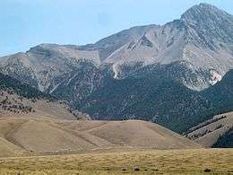
1983 Borah Peak earthquake
 | |
 Challis Boise | |
| Date | October 28, 1983 |
|---|---|
| Origin time | 14:06:09 UTC [1] |
| Magnitude | 6.9 Mw [1] |
| Depth | 16 km (9.9 mi) [2] |
| Epicenter | 44°05′N 113°48′W / 44.08°N 113.8°WCoordinates: 44°05′N 113°48′W / 44.08°N 113.8°W [2] |
| Type | Dip-slip [3] |
| Areas affected |
Central Idaho United States |
| Total damage | $12.5 million USD [4] |
| Max. intensity | IX (Violent) [4] |
| Landslides | Yes |
| Aftershocks |
5.6 Mw Oct 28 at 19:51 UTC [2] 5.5 Mw Oct 29 at 23:29 UTC [2] |
| Casualties | 2 killed, three injured [2] |
The 1983 Borah Peak earthquake occurred on October 28 at 8:06:09 local time in the Lost River Range at Borah Peak in central Idaho, United States. The shock measured 6.9 on the moment magnitude scale and had a maximum Mercalli intensity of IX (Violent).
Earthquake
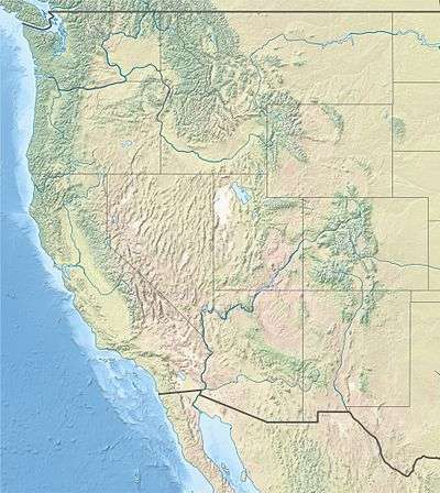
The event is the largest and most significant to strike in the state of Idaho. Two children were killed by falling masonry while walking to school in Challis, about 120 miles (200 km) northeast of Boise, the state's capital. Twelve and a half million dollars in damage took place in the Challis-Mackay region. As a result of extreme surface faulting, a maximum Mercalli intensity of IX (Violent) was decided upon, while vibrational damage was at a Mercalli intensity of VI (Strong) to VII (Very strong).[4]
Surface faulting
The rupture caused clear surface faulting. A 21-mile (34 km) long northwest-moving zone of fresh scarps and ground ruptures was present on a slope of the Lost River Range. Extensive breakage occurred along a 5-mile (8 km) zone between West Spring and Cedar Creek; ground surface was literally "shattered" into tilted blocks, each meters in width. These scarps were as broad as 330 feet (100 m).[4]
Damage
The Challis-Mackay region experienced rather thorough damage, with 11 commercial buildings and 39 homes with major damage; while another 200 houses were damaged, minor to moderately. Mackay in particular, about 50 miles (80 km) southeast of Challis, experienced the most severe damage. Most of the city's large buildings on its Main Street were damaged, to some extent; eight of these buildings were deemed condemned and closed down. Most of these buildings were built from materials such as brick, concrete block, and stone, each varying.[4]
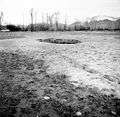
Sand blows
Near Chilly Buttes of Thousand Springs Valley, a series of artesian fountains/sand blows erupted immediately after the main shock. Groundwater gushed from these fountains forming small craters and depositing aprons of light-colored sandy sediment around each crater.
-
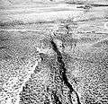
Fault scarps that outline the graben produced near Willow Creek
-
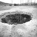
Crater caused by an artesian fountain
-
Another view of an artesian fountain
References
- 1 2 ISC (2015), ISC-GEM Global Instrumental Earthquake Catalogue (1900–2009), Version 2.0, International Seismological Centre
- 1 2 3 4 5 USGS (September 4, 2009), PAGER-CAT Earthquake Catalog, Version 2008_06.1, United States Geological Survey
- ↑ Yeats, R. (2012), Active Faults of the World, Cambridge University Press, pp. 125, 135, ISBN 978-0-521-19085-5
- 1 2 3 4 5 Stover, C. W.; Coffman, J. L. (1993), Seismicity of the United States, 1568–1989 (Revised) – U.S. Geological Survey Professional Paper 1527, United States Government Printing Office, pp. 216–221
External links
- Borah Peak earthquake – Idaho Geological Survey
- Historic Earthquakes (Borah Peak, Idaho ) – United States Geological Survey
- Two children die as quake hits northwest and Canada – The New York Times