Boudy-de-Beauregard
| Boudy-de-Beauregard | |
|---|---|
|
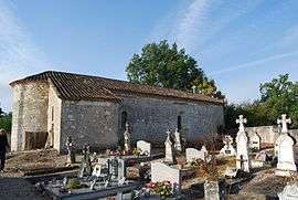
The church in Boudy-de-Beauregard | |
 Boudy-de-Beauregard | |
|
Location within Nouvelle-Aquitaine region  Boudy-de-Beauregard | |
| Coordinates: 44°32′22″N 0°41′24″E / 44.5394°N 0.69°ECoordinates: 44°32′22″N 0°41′24″E / 44.5394°N 0.69°E | |
| Country | France |
| Region | Nouvelle-Aquitaine |
| Department | Lot-et-Garonne |
| Arrondissement | Villeneuve-sur-Lot |
| Canton | Cancon |
| Government | |
| • Mayor (2008–2014) | Philippe Belves |
| Area1 | 10.07 km2 (3.89 sq mi) |
| Population (2009)2 | 398 |
| • Density | 40/km2 (100/sq mi) |
| Time zone | CET (UTC+1) |
| • Summer (DST) | CEST (UTC+2) |
| INSEE/Postal code | 47033 / 47290 |
| Elevation | 82–156 m (269–512 ft) |
|
1 French Land Register data, which excludes lakes, ponds, glaciers > 1 km² (0.386 sq mi or 247 acres) and river estuaries. 2 Population without double counting: residents of multiple communes (e.g., students and military personnel) only counted once. | |
Boudy-de-Beauregard is a commune in the Lot-et-Garonne department in southwestern France.
Population
| Historical population | ||
|---|---|---|
| Year | Pop. | ±% |
| 1800 | 387 | — |
| 1806 | 429 | +10.9% |
| 1821 | 450 | +4.9% |
| 1831 | 468 | +4.0% |
| 1836 | 449 | −4.1% |
| 1841 | 448 | −0.2% |
| 1846 | 411 | −8.3% |
| 1851 | 386 | −6.1% |
| 1856 | 382 | −1.0% |
| 1861 | 362 | −5.2% |
| 1866 | 352 | −2.8% |
| 1872 | 339 | −3.7% |
| 1881 | 336 | −0.9% |
| 1886 | 348 | +3.6% |
| 1891 | 315 | −9.5% |
| 1896 | 301 | −4.4% |
| 1901 | 299 | −0.7% |
| 1906 | 276 | −7.7% |
| 1911 | 275 | −0.4% |
| 1921 | 252 | −8.4% |
| 1926 | 252 | +0.0% |
| 1931 | 257 | +2.0% |
| 1936 | 228 | −11.3% |
| 1946 | 241 | +5.7% |
| 1954 | 206 | −14.5% |
| 1962 | 210 | +1.9% |
| 1968 | 215 | +2.4% |
| 1982 | 237 | +10.2% |
| 1990 | 314 | +32.5% |
| 1999 | 356 | +13.4% |
| 2006 | 383 | +7.6% |
| 2009 | 398 | +3.9% |
See also
References
| Wikimedia Commons has media related to Boudy-de-Beauregard. |
This article is issued from Wikipedia - version of the 9/17/2015. The text is available under the Creative Commons Attribution/Share Alike but additional terms may apply for the media files.