Saint-Vite
| Saint-Vite | |
|---|---|
|
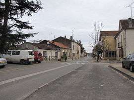
A street in Saint-Vite | |
 Saint-Vite | |
|
Location within Nouvelle-Aquitaine region  Saint-Vite | |
| Coordinates: 44°28′28″N 0°56′28″E / 44.4744°N 0.9411°ECoordinates: 44°28′28″N 0°56′28″E / 44.4744°N 0.9411°E | |
| Country | France |
| Region | Nouvelle-Aquitaine |
| Department | Lot-et-Garonne |
| Arrondissement | Villeneuve-sur-Lot |
| Canton | Tournon-d'Agenais |
| Intercommunality | Fumelois-Lémance |
| Government | |
| • Mayor (2008–2014) | Daniel Borie |
| Area1 | 5.47 km2 (2.11 sq mi) |
| Population (1999)2 | 1,231 |
| • Density | 230/km2 (580/sq mi) |
| Time zone | CET (UTC+1) |
| • Summer (DST) | CEST (UTC+2) |
| INSEE/Postal code | 47283 / 47500 |
| Elevation |
57–105 m (187–344 ft) (avg. 70 m or 230 ft) |
|
1 French Land Register data, which excludes lakes, ponds, glaciers > 1 km² (0.386 sq mi or 247 acres) and river estuaries. 2 Population without double counting: residents of multiple communes (e.g., students and military personnel) only counted once. | |
Saint-Vite is a commune in the Lot-et-Garonne department in south-western France.[1]
See also
| Wikimedia Commons has media related to Saint-Vite. |
References
- ↑ "Insee - COG - Commune de Saint-Vite (47283)". www.insee.fr. Retrieved 2016-07-19.
This article is issued from Wikipedia - version of the 7/19/2016. The text is available under the Creative Commons Attribution/Share Alike but additional terms may apply for the media files.