Tonneins
| Tonneins | ||
|---|---|---|
|
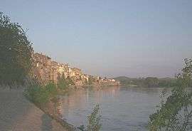
The Garonne river at Tonneins | ||
| ||
 Tonneins | ||
|
Location within Nouvelle-Aquitaine region  Tonneins | ||
| Coordinates: 44°23′26″N 0°18′33″E / 44.3906°N 0.3092°ECoordinates: 44°23′26″N 0°18′33″E / 44.3906°N 0.3092°E | ||
| Country | France | |
| Region | Nouvelle-Aquitaine | |
| Department | Lot-et-Garonne | |
| Arrondissement | Marmande | |
| Canton | Tonneins | |
| Intercommunality | Communauté de communes du Val de Garonne | |
| Government | ||
| • Mayor (2008–2014) | Jean-Pierre Moga | |
| Area1 | 34.78 km2 (13.43 sq mi) | |
| Population (2006)2 | 9,141 | |
| • Density | 260/km2 (680/sq mi) | |
| Time zone | CET (UTC+1) | |
| • Summer (DST) | CEST (UTC+2) | |
| INSEE/Postal code | 47310 / 47400 | |
| Elevation |
21–166 m (69–545 ft) (avg. 39 m or 128 ft) | |
|
1 French Land Register data, which excludes lakes, ponds, glaciers > 1 km² (0.386 sq mi or 247 acres) and river estuaries. 2 Population without double counting: residents of multiple communes (e.g., students and military personnel) only counted once. | ||
.svg.png)
Tonneins is a town in the Lot-et-Garonne department of south-western France. It stands above the river Garonne, between Marmande to the west and Agen to the east, and is the first major town below the confluence of the Lot and Garonne Rivers after which the department is named.
Until the early 2000s, it was the tobacco capital of France. It is known for its quays alongside which the tobacco barges were previously moored. When the tobacco factory closed down in 2004 and production moved to Spain, the town was badly affected economically with the loss of more than 500 jobs. The surrounding countryside still contains many wooden sheds, known locally as 'sechoirs', formerly used to dry the tobacco leaves. The commune of Tonneins is largely agricultural, the principal crops now being maize, rapeseed and sunflowers.
See also
Twin towns
| Wikimedia Commons has media related to Tonneins. |