Nérac
| Nérac | ||
|---|---|---|
|
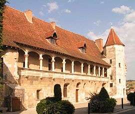
The castle of Nérac | ||
| ||
 Nérac | ||
|
Location within Nouvelle-Aquitaine region  Nérac | ||
| Coordinates: 44°09′N 0°20′E / 44.15°N 0.34°ECoordinates: 44°09′N 0°20′E / 44.15°N 0.34°E | ||
| Country | France | |
| Region | Nouvelle-Aquitaine | |
| Department | Lot-et-Garonne | |
| Arrondissement | Nérac | |
| Canton | Nérac | |
| Intercommunality | Val d'Albret | |
| Area1 | 62.68 km2 (24.20 sq mi) | |
| Population (1999)2 | 6,787 | |
| • Density | 110/km2 (280/sq mi) | |
| Time zone | CET (UTC+1) | |
| • Summer (DST) | CEST (UTC+2) | |
| INSEE/Postal code | 47195 / 47600 | |
| Elevation |
38–191 m (125–627 ft) (avg. 71 m or 233 ft) | |
|
1 French Land Register data, which excludes lakes, ponds, glaciers > 1 km² (0.386 sq mi or 247 acres) and river estuaries. 2 Population without double counting: residents of multiple communes (e.g., students and military personnel) only counted once. | ||
.svg.png)
Nérac (French pronunciation: [neʁak]) is a commune in the Lot-et-Garonne department in south-western France.
See also
External links
- Town council website (French)
| Wikimedia Commons has media related to Nérac. |
This article is issued from Wikipedia - version of the 4/7/2016. The text is available under the Creative Commons Attribution/Share Alike but additional terms may apply for the media files.