Puymirol
| Puymirol | ||
|---|---|---|
|
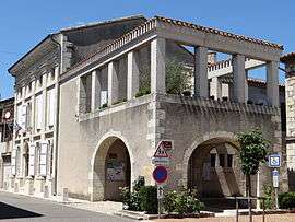
The town hall in Puymirol | ||
| ||
 Puymirol | ||
|
Location within Nouvelle-Aquitaine region  Puymirol | ||
| Coordinates: 44°11′16″N 0°47′54″E / 44.1878°N 0.7983°ECoordinates: 44°11′16″N 0°47′54″E / 44.1878°N 0.7983°E | ||
| Country | France | |
| Region | Nouvelle-Aquitaine | |
| Department | Lot-et-Garonne | |
| Arrondissement | Agen | |
| Canton | Puymirol | |
| Intercommunality | Communauté de communes des Deux Séounes | |
| Government | ||
| • Mayor (2001–2008) | Jean-Louis Coureau | |
| Area1 | 19.54 km2 (7.54 sq mi) | |
| Population (1999)2 | 864 | |
| • Density | 44/km2 (110/sq mi) | |
| Time zone | CET (UTC+1) | |
| • Summer (DST) | CEST (UTC+2) | |
| INSEE/Postal code | 47217 / 47270 | |
| Elevation |
57–191 m (187–627 ft) (avg. 144 m or 472 ft) | |
|
1 French Land Register data, which excludes lakes, ponds, glaciers > 1 km² (0.386 sq mi or 247 acres) and river estuaries. 2 Population without double counting: residents of multiple communes (e.g., students and military personnel) only counted once. | ||
.svg.png)
Puymirol is a commune in the Lot-et-Garonne department in south-western France.
Geography
The Séoune forms part of the commune's eastern border, flows westward through the middle of the commune, then forms part of its western border.
See also
| Wikimedia Commons has media related to Puymirol. |
This article is issued from Wikipedia - version of the 3/15/2015. The text is available under the Creative Commons Attribution/Share Alike but additional terms may apply for the media files.