Lannes, Lot-et-Garonne
| Lannes | |
|---|---|
|
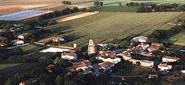
An aerial view of Lannes | |
 Lannes | |
|
Location within Nouvelle-Aquitaine region  Lannes | |
| Coordinates: 44°02′10″N 0°17′39″E / 44.0361°N 0.2942°ECoordinates: 44°02′10″N 0°17′39″E / 44.0361°N 0.2942°E | |
| Country | France |
| Region | Nouvelle-Aquitaine |
| Department | Lot-et-Garonne |
| Arrondissement | Arrondissement of Nérac |
| Canton | Canton of Mézin |
| Intercommunality | Communauté de communes du Mézinais |
| Government | |
| • Mayor (2008–2014) | Michel Kauffer |
| Area1 | 32.4 km2 (12.5 sq mi) |
| Population (1999)2 | 428 |
| • Density | 13/km2 (34/sq mi) |
| Time zone | CET (UTC+1) |
| • Summer (DST) | CEST (UTC+2) |
| INSEE/Postal code | 47134 / 47170 |
| Elevation |
58–171 m (190–561 ft) (avg. 75 m or 246 ft) |
|
1 French Land Register data, which excludes lakes, ponds, glaciers > 1 km² (0.386 sq mi or 247 acres) and river estuaries. 2 Population without double counting: residents of multiple communes (e.g., students and military personnel) only counted once. | |
Lannes is a commune in the Lot-et-Garonne department in south-western France.
Geography
The Auzoue forms part of the commune's southwestern border.
The Osse forms the commune's eastern border.
See also
| Wikimedia Commons has media related to Lannes (Lot-et-Garonne). |
This article is issued from Wikipedia - version of the 3/15/2015. The text is available under the Creative Commons Attribution/Share Alike but additional terms may apply for the media files.