Champlemy
| Champlemy | |
|---|---|
|
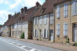
Houses on the main road in Champlemy | |
 Champlemy | |
|
Location within Bourgogne-Franche-Comté region  Champlemy | |
| Coordinates: 47°17′12″N 3°21′07″E / 47.2867°N 3.3519°ECoordinates: 47°17′12″N 3°21′07″E / 47.2867°N 3.3519°E | |
| Country | France |
| Region | Bourgogne-Franche-Comté |
| Department | Nièvre |
| Arrondissement | Cosne-Cours-sur-Loire |
| Canton | Prémery |
| Intercommunality | Nièvres et Forêts |
| Government | |
| • Mayor (2001–2008) | René Faust |
| Area1 | 36.82 km2 (14.22 sq mi) |
| Population (1999)2 | 323 |
| • Density | 8.8/km2 (23/sq mi) |
| Time zone | CET (UTC+1) |
| • Summer (DST) | CEST (UTC+2) |
| INSEE/Postal code | 58053 / 58210 |
| Elevation | 240–381 m (787–1,250 ft) |
|
1 French Land Register data, which excludes lakes, ponds, glaciers > 1 km² (0.386 sq mi or 247 acres) and river estuaries. 2 Population without double counting: residents of multiple communes (e.g., students and military personnel) only counted once. | |
Champlemy is a commune in the Nièvre department in central France.
Demographics
At the 1999 census, the population was 323. On 1 January 2004, the estimate was 336.
See also
References
| Wikimedia Commons has media related to Champlemy. |
This article is issued from Wikipedia - version of the 3/15/2016. The text is available under the Creative Commons Attribution/Share Alike but additional terms may apply for the media files.