Germenay
| Germenay | |
|---|---|
|
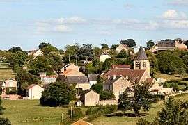
The church and surrounding buildings in Germenay | |
 Germenay | |
|
Location within Bourgogne-Franche-Comté region  Germenay | |
| Coordinates: 47°16′59″N 3°35′47″E / 47.2831°N 3.5964°ECoordinates: 47°16′59″N 3°35′47″E / 47.2831°N 3.5964°E | |
| Country | France |
| Region | Bourgogne-Franche-Comté |
| Department | Nièvre |
| Arrondissement | Clamecy |
| Canton | Brinon-sur-Beuvron |
| Intercommunality | Pays Corbigeois |
| Government | |
| • Mayor (2001–2008) | Lucien Merle |
| Area1 | 12.91 km2 (4.98 sq mi) |
| Population (1999)2 | 142 |
| • Density | 11/km2 (28/sq mi) |
| Time zone | CET (UTC+1) |
| • Summer (DST) | CEST (UTC+2) |
| INSEE/Postal code | 58123 / 58800 |
| Elevation | 180–286 m (591–938 ft) |
|
1 French Land Register data, which excludes lakes, ponds, glaciers > 1 km² (0.386 sq mi or 247 acres) and river estuaries. 2 Population without double counting: residents of multiple communes (e.g., students and military personnel) only counted once. | |
Germenay is a commune in the Nièvre department in central France.
Demographics
At the 1999 census, the population was 142. On 1 January 2005, the estimate was said to be 145.
See also
References
| Wikimedia Commons has media related to Germenay. |
This article is issued from Wikipedia - version of the 3/13/2015. The text is available under the Creative Commons Attribution/Share Alike but additional terms may apply for the media files.