Sémelay
| Sémelay | |
|---|---|
|
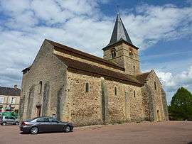
The church in Sémelay | |
 Sémelay | |
|
Location within Bourgogne-Franche-Comté region  Sémelay | |
| Coordinates: 46°51′09″N 3°51′07″E / 46.85250°N 3.8519°ECoordinates: 46°51′09″N 3°51′07″E / 46.85250°N 3.8519°E | |
| Country | France |
| Region | Bourgogne-Franche-Comté |
| Department | Nièvre |
| Arrondissement | Château-Chinon |
| Canton | Luzy |
| Government | |
| • Mayor (2001–2008) | Guy Laffaye |
| Area1 | 33.53 km2 (12.95 sq mi) |
| Population (1999)2 | 279 |
| • Density | 8.3/km2 (22/sq mi) |
| Time zone | CET (UTC+1) |
| • Summer (DST) | CEST (UTC+2) |
| INSEE/Postal code | 58276 / 58360 |
| Elevation | 227–530 m (745–1,739 ft) |
|
1 French Land Register data, which excludes lakes, ponds, glaciers > 1 km² (0.386 sq mi or 247 acres) and river estuaries. 2 Population without double counting: residents of multiple communes (e.g., students and military personnel) only counted once. | |
Sémelay is a commune in the Nièvre department in central France. The town of Sémelay belongs to the canton of Luzy and the district of Château-Chinon(Ville).[1]
Geography
The river Alène flows westward through the southern part of commune.
The town's surface is 33.4 km². It is situated at an altitude of about 292 meters. It Is situated "at altitude of about 292 year meters.[2]
Demographics
At the 1999 census, the population was 279. On 1 January 2004, the estimate was 268.
See also
References
| Wikimedia Commons has media related to Sémelay. |
This article is issued from Wikipedia - version of the 2/11/2016. The text is available under the Creative Commons Attribution/Share Alike but additional terms may apply for the media files.