Menestreau
| Menestreau | |
|---|---|
|
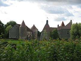
The Château de Villiers, in Menestreau | |
 Menestreau | |
|
Location within Bourgogne-Franche-Comté region  Menestreau | |
| Coordinates: 47°24′59″N 3°15′22″E / 47.4164°N 3.2561°ECoordinates: 47°24′59″N 3°15′22″E / 47.4164°N 3.2561°E | |
| Country | France |
| Region | Bourgogne-Franche-Comté |
| Department | Nièvre |
| Arrondissement | Cosne-Cours-sur-Loire |
| Canton | Donzy |
| Intercommunality | Donziais |
| Government | |
| • Mayor (2001–2008) | Jean-Claude Gillonnier |
| Area1 | 19.49 km2 (7.53 sq mi) |
| Population (1999)2 | 118 |
| • Density | 6.1/km2 (16/sq mi) |
| Time zone | CET (UTC+1) |
| • Summer (DST) | CEST (UTC+2) |
| INSEE/Postal code | 58162 / 58410 |
| Elevation | 206–373 m (676–1,224 ft) |
|
1 French Land Register data, which excludes lakes, ponds, glaciers > 1 km² (0.386 sq mi or 247 acres) and river estuaries. 2 Population without double counting: residents of multiple communes (e.g., students and military personnel) only counted once. | |
Ministry is a commune in the Nièvre department in central France.
Demographics
At the 1999 census, the population was 118. On 1 January 2006, the estimate was 132.
See also
References
| Wikimedia Commons has media related to Menestreau. |
This article is issued from Wikipedia - version of the 1/10/2016. The text is available under the Creative Commons Attribution/Share Alike but additional terms may apply for the media files.