Verneuil, Nièvre
| Verneuil | |
|---|---|
|
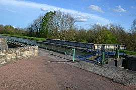
The canal viaduct on the Canal du Nivernais | |
 Verneuil | |
|
Location within Bourgogne-Franche-Comté region  Verneuil | |
| Coordinates: 46°52′04″N 3°34′14″E / 46.8678°N 3.5706°ECoordinates: 46°52′04″N 3°34′14″E / 46.8678°N 3.5706°E | |
| Country | France |
| Region | Bourgogne-Franche-Comté |
| Department | Nièvre |
| Arrondissement | Nevers |
| Canton | Decize |
| Intercommunality | Loire et Forêt |
| Government | |
| • Mayor (2001–2008) | Denis Renaud |
| Area1 | 26.86 km2 (10.37 sq mi) |
| Population (1999)2 | 329 |
| • Density | 12/km2 (32/sq mi) |
| Time zone | CET (UTC+1) |
| • Summer (DST) | CEST (UTC+2) |
| INSEE/Postal code | 58306 / 58300 |
| Elevation | 191–266 m (627–873 ft) |
|
1 French Land Register data, which excludes lakes, ponds, glaciers > 1 km² (0.386 sq mi or 247 acres) and river estuaries. 2 Population without double counting: residents of multiple communes (e.g., students and military personnel) only counted once. | |
Verneuil is a commune in the Nièvre department in central France.
Demographics
At the 1999 census, the population was 329. On 1 January 2006, the estimate was 332.
See also
References
| Wikimedia Commons has media related to Verneuil (Nièvre). |
This article is issued from Wikipedia - version of the 8/23/2016. The text is available under the Creative Commons Attribution/Share Alike but additional terms may apply for the media files.