Montreuillon
| Montreuillon | |
|---|---|
|
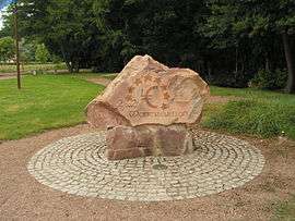
Former centre of the Eurozone | |
 Montreuillon | |
|
Location within Bourgogne-Franche-Comté region  Montreuillon | |
| Coordinates: 47°10′29″N 3°47′20″E / 47.1747°N 3.7889°ECoordinates: 47°10′29″N 3°47′20″E / 47.1747°N 3.7889°E | |
| Country | France |
| Region | Bourgogne-Franche-Comté |
| Department | Nièvre |
| Arrondissement | Château-Chinon |
| Canton | Château-Chinon |
| Intercommunality | Haut Morvan |
| Government | |
| • Mayor (2001–2008) | Serge Millot |
| Area1 | 35.55 km2 (13.73 sq mi) |
| Population (1999)2 | 308 |
| • Density | 8.7/km2 (22/sq mi) |
| Time zone | CET (UTC+1) |
| • Summer (DST) | CEST (UTC+2) |
| INSEE/Postal code | 58179 / 58800 |
| Elevation | 229–426 m (751–1,398 ft) |
|
1 French Land Register data, which excludes lakes, ponds, glaciers > 1 km² (0.386 sq mi or 247 acres) and river estuaries. 2 Population without double counting: residents of multiple communes (e.g., students and military personnel) only counted once. | |
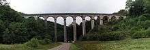
Montreuillon Aqueduct
Montreuillon is a commune in the Nièvre department in central France.
Demographics
At the 1999 census, the population was 308. On 1 January 2007, the estimate was 311.
Eurozone
Montreuillon was formerly the official centre of the Eurozone
Canal du Nivernais
It is the site of an impressive aqueduct over which runs the feeder canal linking the Pannecière reservoir with the Canal du Nivernais.
See also
References
| Wikimedia Commons has media related to Montreuillon. |
This article is issued from Wikipedia - version of the 2/11/2016. The text is available under the Creative Commons Attribution/Share Alike but additional terms may apply for the media files.