Saint-Pierre-le-Moûtier
| Saint-Pierre-le-Moûtier | ||
|---|---|---|
|
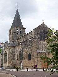
The church in Saint-Pierre-le-Moûtier | ||
| ||
 Saint-Pierre-le-Moûtier | ||
|
Location within Bourgogne-Franche-Comté region  Saint-Pierre-le-Moûtier | ||
| Coordinates: 46°47′30″N 3°07′08″E / 46.7917°N 3.1189°ECoordinates: 46°47′30″N 3°07′08″E / 46.7917°N 3.1189°E | ||
| Country | France | |
| Region | Bourgogne-Franche-Comté | |
| Department | Nièvre | |
| Arrondissement | Nevers | |
| Canton | Saint-Pierre-le-Moûtier | |
| Intercommunality | Nivernais Bourbonnais | |
| Area1 | 47.67 km2 (18.41 sq mi) | |
| Population (2012)2 | 2,030 | |
| • Density | 43/km2 (110/sq mi) | |
| Time zone | CET (UTC+1) | |
| • Summer (DST) | CEST (UTC+2) | |
| INSEE/Postal code | 58264 / 58240 | |
| Elevation | 188–264 m (617–866 ft) | |
|
1 French Land Register data, which excludes lakes, ponds, glaciers > 1 km² (0.386 sq mi or 247 acres) and river estuaries. 2 Population without double counting: residents of multiple communes (e.g., students and military personnel) only counted once. | ||

Saint-Pierre-le-Moûtier is a commune in the Nièvre department in central France. It was besieged during the Lancastrian War.
See also
References
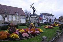
Statue of Jeanne d'Arc
| Wikimedia Commons has media related to Saint-Pierre-le-Moûtier. |
This article is issued from Wikipedia - version of the 5/2/2016. The text is available under the Creative Commons Attribution/Share Alike but additional terms may apply for the media files.