Chabrillan
| Chabrillan | |
|---|---|
 | |
 Chabrillan | |
|
Location within Auvergne-Rhône-Alpes region  Chabrillan | |
| Coordinates: 44°43′28″N 4°56′32″E / 44.7244°N 4.9422°ECoordinates: 44°43′28″N 4°56′32″E / 44.7244°N 4.9422°E | |
| Country | France |
| Region | Auvergne-Rhône-Alpes |
| Department | Drôme |
| Arrondissement | Die |
| Canton | Crest-Sud |
| Intercommunality | Val de Drôme |
| Government | |
| • Mayor (2008–2014) | Alain Charrier |
| Area1 | 17.75 km2 (6.85 sq mi) |
| Population (2008)2 | 659 |
| • Density | 37/km2 (96/sq mi) |
| Time zone | CET (UTC+1) |
| • Summer (DST) | CEST (UTC+2) |
| INSEE/Postal code | 26065 / 26400 |
| Elevation | 149–352 m (489–1,155 ft) |
|
1 French Land Register data, which excludes lakes, ponds, glaciers > 1 km² (0.386 sq mi or 247 acres) and river estuaries. 2 Population without double counting: residents of multiple communes (e.g., students and military personnel) only counted once. | |
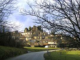
Chabrillan is a commune of the Drôme département in southeastern France.
Population
| Historical population | ||
|---|---|---|
| Year | Pop. | ±% |
| 1911 | 707 | — |
| 1962 | 519 | −26.6% |
| 1968 | 474 | −8.7% |
| 1975 | 494 | +4.2% |
| 1982 | 544 | +10.1% |
| 1990 | 629 | +15.6% |
| 1999 | 608 | −3.3% |
| 2008 | 659 | +8.4% |
Sights and monuments
The French Ministry of Culture has designated two buildings as monuments historiques in Chabrillan:
- Château de Chabrillan, ruins of medieval castle.[1]
- Eglise Saint-Pierre, the church.[2]
See also
References
- ↑ Ministry of Culture: Chabrillan: Château (restes) (French)
- ↑ Ministry of Culture: Chabrillan: Eglise Saint-Pierre (French)
External links
| Wikimedia Commons has media related to Chabrillan. |
- Ministry of Culture listing Château de Chabrillan (French) and Ministry of Culture photos
- Ministry of Culture listing Eglise Saint-Pierre (French) and Ministry of Culture photos
This article is issued from Wikipedia - version of the 10/28/2016. The text is available under the Creative Commons Attribution/Share Alike but additional terms may apply for the media files.