Glandage
| Glandage | |
|---|---|
|
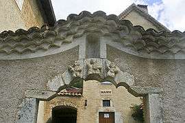
Town hall | |
 Glandage | |
|
Location within Auvergne-Rhône-Alpes region  Glandage | |
| Coordinates: 44°41′20″N 5°35′56″E / 44.6889°N 5.5989°ECoordinates: 44°41′20″N 5°35′56″E / 44.6889°N 5.5989°E | |
| Country | France |
| Region | Auvergne-Rhône-Alpes |
| Department | Drôme |
| Arrondissement | Die |
| Canton | Châtillon-en-Diois |
| Intercommunality | Diois |
| Government | |
| • Mayor (2008–2014) | René Orand |
| Area1 | 52.11 km2 (20.12 sq mi) |
| Population (2008)2 | 93 |
| • Density | 1.8/km2 (4.6/sq mi) |
| Time zone | CET (UTC+1) |
| • Summer (DST) | CEST (UTC+2) |
| INSEE/Postal code | 26142 / 26410 |
| Elevation | 717–2,045 m (2,352–6,709 ft) |
|
1 French Land Register data, which excludes lakes, ponds, glaciers > 1 km² (0.386 sq mi or 247 acres) and river estuaries. 2 Population without double counting: residents of multiple communes (e.g., students and military personnel) only counted once. | |
Glandage is a commune in the Drôme department in southeastern France.
Population
| Historical population | ||
|---|---|---|
| Year | Pop. | ±% |
| 1911 | 439 | — |
| 1962 | 75 | −82.9% |
| 1968 | 99 | +32.0% |
| 1975 | 83 | −16.2% |
| 1982 | 121 | +45.8% |
| 1990 | 111 | −8.3% |
| 1999 | 84 | −24.3% |
| 2008 | 93 | +10.7% |
See also
References
| Wikimedia Commons has media related to Glandage. |
This article is issued from Wikipedia - version of the 10/28/2016. The text is available under the Creative Commons Attribution/Share Alike but additional terms may apply for the media files.