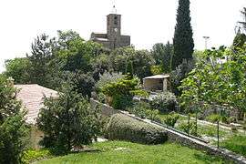
Mérindol-les-Oliviers
| Mérindol-les-Oliviers | ||
|---|---|---|
 | ||
| ||
 Mérindol-les-Oliviers | ||
|
Location within Auvergne-Rhône-Alpes region  Mérindol-les-Oliviers | ||
| Coordinates: 44°16′29″N 5°10′06″E / 44.2747°N 5.1683°ECoordinates: 44°16′29″N 5°10′06″E / 44.2747°N 5.1683°E | ||
| Country | France | |
| Region | Auvergne-Rhône-Alpes | |
| Department | Drôme | |
| Arrondissement | Nyons | |
| Canton | Buis-les-Baronnies | |
| Intercommunality | Pays du Buis-les-Baronnies | |
| Government | ||
| • Mayor (2008–2014) | Annie Koutsoulis | |
| Area1 | 9.23 km2 (3.56 sq mi) | |
| Population (2008)2 | 194 | |
| • Density | 21/km2 (54/sq mi) | |
| Time zone | CET (UTC+1) | |
| • Summer (DST) | CEST (UTC+2) | |
| INSEE/Postal code | 26180 / 26170 | |
| Elevation | 266–782 m (873–2,566 ft) | |
|
1 French Land Register data, which excludes lakes, ponds, glaciers > 1 km² (0.386 sq mi or 247 acres) and river estuaries. 2 Population without double counting: residents of multiple communes (e.g., students and military personnel) only counted once. | ||
.svg.png)
Mérindol-les-Oliviers is a commune in the Drôme department in southeastern France.
Population
| Historical population | ||
|---|---|---|
| Year | Pop. | ±% |
| 1911 | 231 | — |
| 1962 | 201 | −13.0% |
| 1968 | 201 | +0.0% |
| 1975 | 200 | −0.5% |
| 1982 | 171 | −14.5% |
| 1990 | 201 | +17.5% |
| 1999 | 201 | +0.0% |
| 2008 | 194 | −3.5% |
See also
References
| Wikimedia Commons has media related to Mérindol-les-Oliviers. |
This article is issued from Wikipedia - version of the 8/16/2016. The text is available under the Creative Commons Attribution/Share Alike but additional terms may apply for the media files.