La Garde-Adhémar
| La Garde-Adhémar | ||
|---|---|---|
|
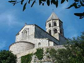
Saint-Michel Church | ||
| ||
 La Garde-Adhémar | ||
|
Location within Auvergne-Rhône-Alpes region  La Garde-Adhémar | ||
| Coordinates: 44°23′38″N 4°45′17″E / 44.3939°N 4.7547°ECoordinates: 44°23′38″N 4°45′17″E / 44.3939°N 4.7547°E | ||
| Country | France | |
| Region | Auvergne-Rhône-Alpes | |
| Department | Drôme | |
| Arrondissement | Nyons | |
| Canton | Pierrelatte | |
| Government | ||
| • Mayor (2008–2014) | Christian Andruejol | |
| Area1 | 27.73 km2 (10.71 sq mi) | |
| Population (2008)2 | 1,141 | |
| • Density | 41/km2 (110/sq mi) | |
| Time zone | CET (UTC+1) | |
| • Summer (DST) | CEST (UTC+2) | |
| INSEE/Postal code | 26138 / 26700 | |
| Elevation | 54–232 m (177–761 ft) | |
|
1 French Land Register data, which excludes lakes, ponds, glaciers > 1 km² (0.386 sq mi or 247 acres) and river estuaries. 2 Population without double counting: residents of multiple communes (e.g., students and military personnel) only counted once. | ||
.svg.png)
La Garde-Adhémar is a commune in the Drôme department in southeastern France.
Population
| Historical population | ||
|---|---|---|
| Year | Pop. | ±% |
| 1860 | 1,260 | — |
| 1911 | 807 | −36.0% |
| 1962 | 510 | −36.8% |
| 1968 | 550 | +7.8% |
| 1975 | 880 | +60.0% |
| 1982 | 1,077 | +22.4% |
| 1990 | 1,108 | +2.9% |
| 1999 | 1,075 | −3.0% |
| 2008 | 1,141 | +6.1% |
See also
References
| Wikimedia Commons has media related to La Garde-Adhémar. |
This article is issued from Wikipedia - version of the 2/11/2016. The text is available under the Creative Commons Attribution/Share Alike but additional terms may apply for the media files.