Eygalayes
| Eygalayes | |
|---|---|
|
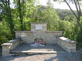
Monument to Resistance fighters | |
 Eygalayes | |
|
Location within Auvergne-Rhône-Alpes region  Eygalayes | |
| Coordinates: 44°14′24″N 5°36′30″E / 44.24°N 5.6083°ECoordinates: 44°14′24″N 5°36′30″E / 44.24°N 5.6083°E | |
| Country | France |
| Region | Auvergne-Rhône-Alpes |
| Department | Drôme |
| Arrondissement | Nyons |
| Canton | Séderon |
| Intercommunality | Canton de Ribiers Val de Méouge |
| Government | |
| • Mayor (2008–2014) | Josette Fournier |
| Area1 | 17.97 km2 (6.94 sq mi) |
| Population (2008)2 | 70 |
| • Density | 3.9/km2 (10/sq mi) |
| Time zone | CET (UTC+1) |
| • Summer (DST) | CEST (UTC+2) |
| INSEE/Postal code | 26126 / 26560 |
| Elevation | 722–1,484 m (2,369–4,869 ft) |
|
1 French Land Register data, which excludes lakes, ponds, glaciers > 1 km² (0.386 sq mi or 247 acres) and river estuaries. 2 Population without double counting: residents of multiple communes (e.g., students and military personnel) only counted once. | |
Eygalayes is a commune in the Drôme department in the Auvergne-Rhône-Alpes region in southeastern France.
Population
| Historical population | ||
|---|---|---|
| Year | Pop. | ±% |
| 1911 | 259 | — |
| 1962 | 98 | −62.2% |
| 1968 | 106 | +8.2% |
| 1975 | 89 | −16.0% |
| 1982 | 80 | −10.1% |
| 1990 | 76 | −5.0% |
| 1999 | 76 | +0.0% |
| 2008 | 70 | −7.9% |
See also
References
| Wikimedia Commons has media related to Eygalayes. |
This article is issued from Wikipedia - version of the 10/28/2016. The text is available under the Creative Commons Attribution/Share Alike but additional terms may apply for the media files.