Pierrelatte
| Pierrelatte | ||
|---|---|---|
| ||
 Pierrelatte | ||
|
Location within Auvergne-Rhône-Alpes region  Pierrelatte | ||
| Coordinates: 44°22′42″N 4°41′47″E / 44.3783°N 4.6964°ECoordinates: 44°22′42″N 4°41′47″E / 44.3783°N 4.6964°E | ||
| Country | France | |
| Region | Auvergne-Rhône-Alpes | |
| Department | Drôme | |
| Arrondissement | Nyons | |
| Canton | Pierrelatte | |
| Government | ||
| • Mayor (2008–2014) | Yves Le Bellec | |
| Area1 | 49.56 km2 (19.14 sq mi) | |
| Population (2008)2 | 12,893 | |
| • Density | 260/km2 (670/sq mi) | |
| Time zone | CET (UTC+1) | |
| • Summer (DST) | CEST (UTC+2) | |
| INSEE/Postal code | 26235 / 26700 | |
| Elevation |
46–61 m (151–200 ft) (avg. 60 m or 200 ft) | |
|
1 French Land Register data, which excludes lakes, ponds, glaciers > 1 km² (0.386 sq mi or 247 acres) and river estuaries. 2 Population without double counting: residents of multiple communes (e.g., students and military personnel) only counted once. | ||
.svg.png)
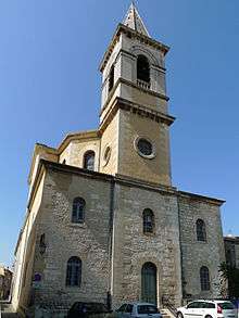
The Église Saint-Jean-Baptiste in Pierrelatte
Pierrelatte (Occitan: Pèiralata) is a commune in the Drôme department in southeastern France.
Population
| Historical population | ||
|---|---|---|
| Year | Pop. | ±% |
| 1793 | 2,789 | — |
| 1800 | 2,536 | −9.1% |
| 1806 | 2,462 | −2.9% |
| 1821 | 2,867 | +16.5% |
| 1831 | 3,447 | +20.2% |
| 1836 | 3,409 | −1.1% |
| 1841 | 3,430 | +0.6% |
| 1846 | 3,537 | +3.1% |
| 1851 | 3,483 | −1.5% |
| 1856 | 3,453 | −0.9% |
| 1861 | 3,512 | +1.7% |
| 1866 | 3,539 | +0.8% |
| 1872 | 3,577 | +1.1% |
| 1876 | 3,579 | +0.1% |
| 1881 | 3,291 | −8.0% |
| 1886 | 3,223 | −2.1% |
| 1891 | 3,184 | −1.2% |
| 1896 | 3,218 | +1.1% |
| 1901 | 3,121 | −3.0% |
| 1906 | 3,319 | +6.3% |
| 1911 | 3,246 | −2.2% |
| 1921 | 3,170 | −2.3% |
| 1926 | 3,252 | +2.6% |
| 1931 | 3,307 | +1.7% |
| 1936 | 3,176 | −4.0% |
| 1946 | 3,237 | +1.9% |
| 1954 | 3,448 | +6.5% |
| 1962 | 4,251 | +23.3% |
| 1968 | 9,757 | +129.5% |
| 1975 | 9,816 | +0.6% |
| 1982 | 11,596 | +18.1% |
| 1990 | 11,770 | +1.5% |
| 1999 | 11,943 | +1.5% |
| 2008 | 12,893 | +8.0% |
Personalities
- Jean Aurenche, screenwriter, was born here in 1905.
- Cédric Séguin, fencer, was born here in 1973.
See also
References
| Wikimedia Commons has media related to Pierrelatte. |
This article is issued from Wikipedia - version of the 10/28/2016. The text is available under the Creative Commons Attribution/Share Alike but additional terms may apply for the media files.