Léoncel
| Léoncel | |
|---|---|
|
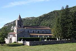
Church of the Abbey of Léoncel | |
 Léoncel | |
|
Location within Auvergne-Rhône-Alpes region  Léoncel | |
| Coordinates: 44°54′41″N 5°11′37″E / 44.9114°N 5.1936°ECoordinates: 44°54′41″N 5°11′37″E / 44.9114°N 5.1936°E | |
| Country | France |
| Region | Auvergne-Rhône-Alpes |
| Department | Drôme |
| Arrondissement | Valence |
| Canton | Saint-Jean-en-Royans |
| Intercommunality | Le Pays du Royans |
| Government | |
| • Mayor (2008–2014) | Raymond Vassal |
| Area1 | 43.01 km2 (16.61 sq mi) |
| Population (2008)2 | 46 |
| • Density | 1.1/km2 (2.8/sq mi) |
| Time zone | CET (UTC+1) |
| • Summer (DST) | CEST (UTC+2) |
| INSEE/Postal code | 26163 / 26190 |
| Elevation |
438–1,447 m (1,437–4,747 ft) (avg. 913 m or 2,995 ft) |
|
1 French Land Register data, which excludes lakes, ponds, glaciers > 1 km² (0.386 sq mi or 247 acres) and river estuaries. 2 Population without double counting: residents of multiple communes (e.g., students and military personnel) only counted once. | |
Léoncel is a commune in the Drôme department in southeastern France.
Population
| Historical population | ||
|---|---|---|
| Year | Pop. | ±% |
| 1911 | 199 | — |
| 1962 | 78 | −60.8% |
| 1968 | 87 | +11.5% |
| 1975 | 83 | −4.6% |
| 1982 | 73 | −12.0% |
| 1990 | 67 | −8.2% |
| 1999 | 55 | −17.9% |
| 2008 | 46 | −16.4% |
See also
References
![]() Media related to Léoncel at Wikimedia Commons
Media related to Léoncel at Wikimedia Commons
This article is issued from Wikipedia - version of the 11/13/2016. The text is available under the Creative Commons Attribution/Share Alike but additional terms may apply for the media files.