Doussard
| Doussard | |
|---|---|
|
Doussard | |
 Doussard | |
|
Location within Auvergne-Rhône-Alpes region  Doussard | |
| Coordinates: 45°46′36″N 6°13′16″E / 45.7767°N 6.2211°ECoordinates: 45°46′36″N 6°13′16″E / 45.7767°N 6.2211°E | |
| Country | France |
| Region | Auvergne-Rhône-Alpes |
| Department | Haute-Savoie |
| Arrondissement | Annecy |
| Canton | Faverges |
| Intercommunality | Communauté de communes du Pays de Faverges |
| Government | |
| • Mayor (2008–2014) | Jean-Claude Deronzier |
| Area1 | 20.14 km2 (7.78 sq mi) |
| Population (1999)2 | 2,781 |
| • Density | 140/km2 (360/sq mi) |
| Time zone | CET (UTC+1) |
| • Summer (DST) | CEST (UTC+2) |
| INSEE/Postal code | 74104 / 74210 |
| Elevation | 442–1,804 m (1,450–5,919 ft) |
| Website | Ville-doussard.fr |
|
1 French Land Register data, which excludes lakes, ponds, glaciers > 1 km² (0.386 sq mi or 247 acres) and river estuaries. 2 Population without double counting: residents of multiple communes (e.g., students and military personnel) only counted once. | |
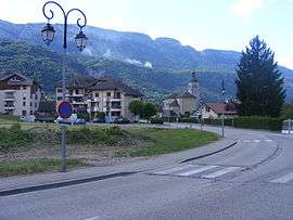
Doussard is a commune in the Haute-Savoie department in the Auvergne-Rhône-Alpes region in south-eastern France.
The village contains a landing field used by many paragliders, usually after they've taken off from the nearby Col de la Forclaz.
See also
References
| Wikimedia Commons has media related to Doussard. |
This article is issued from Wikipedia - version of the 10/28/2016. The text is available under the Creative Commons Attribution/Share Alike but additional terms may apply for the media files.