Essert-Romand
| Essert-Romand | ||
|---|---|---|
|
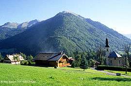
The village of Essert-Romand | ||
| ||
 Essert-Romand | ||
|
Location within Auvergne-Rhône-Alpes region  Essert-Romand | ||
| Coordinates: 46°12′09″N 6°40′19″E / 46.2025°N 6.6719°ECoordinates: 46°12′09″N 6°40′19″E / 46.2025°N 6.6719°E | ||
| Country | France | |
| Region | Auvergne-Rhône-Alpes | |
| Department | Haute-Savoie | |
| Arrondissement | Arrondissement of Thonon-les-Bains | |
| Canton | Canton du Biot | |
| Intercommunality | Communauté de communes de la Vallée d'Aulps | |
| Government | ||
| • Mayor (2008–2014) | Roger Gaillard | |
| Area1 | 6.78 km2 (2.62 sq mi) | |
| Population (1999)2 | 353 | |
| • Density | 52/km2 (130/sq mi) | |
| Time zone | CET (UTC+1) | |
| • Summer (DST) | CEST (UTC+2) | |
| INSEE/Postal code | 74114 / 74110 | |
| Elevation | 837–1,780 m (2,746–5,840 ft) | |
| Website | Essert-romand.fr | |
|
1 French Land Register data, which excludes lakes, ponds, glaciers > 1 km² (0.386 sq mi or 247 acres) and river estuaries. 2 Population without double counting: residents of multiple communes (e.g., students and military personnel) only counted once. | ||
.svg.png)
Essert-Romand is a commune in the Haute-Savoie department in the Auvergne-Rhône-Alpes region in south-eastern France. Bordering the winter skiing resort town of Morzine, Essert Romand is a popular location for holiday homes and ski chalets which are largely unused outside the winter season. There is a small active farming community, farming mainly sheep and goats.
See also
References
| Wikimedia Commons has media related to Essert-Romand. |
This article is issued from Wikipedia - version of the 10/28/2016. The text is available under the Creative Commons Attribution/Share Alike but additional terms may apply for the media files.