Reignier-Esery
| Reignier-Ésery | ||
|---|---|---|
|
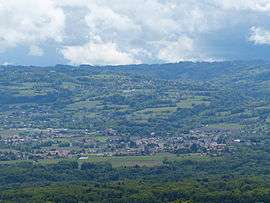
A general view of Reignier-Esery | ||
| ||
 Reignier-Ésery | ||
|
Location within Auvergne-Rhône-Alpes region  Reignier-Ésery | ||
| Coordinates: 46°08′07″N 6°16′09″E / 46.1353°N 6.2692°ECoordinates: 46°08′07″N 6°16′09″E / 46.1353°N 6.2692°E | ||
| Country | France | |
| Region | Auvergne-Rhône-Alpes | |
| Department | Haute-Savoie | |
| Arrondissement | Saint-Julien-en-Genevois | |
| Canton |
Reignier-Ésery (chef-lieu) | |
| Intercommunality | Communauté de communes Arve et Salève | |
| Government | ||
| • Mayor (2008–2014) | Jean-François Ciclet | |
| Area1 | 25.08 km2 (9.68 sq mi) | |
| Population (1999)2 | 5,269 | |
| • Density | 210/km2 (540/sq mi) | |
| Time zone | CET (UTC+1) | |
| • Summer (DST) | CEST (UTC+2) | |
| INSEE/Postal code | 74220 / 74930 | |
| Elevation | 410–832 m (1,345–2,730 ft) | |
|
1 French Land Register data, which excludes lakes, ponds, glaciers > 1 km² (0.386 sq mi or 247 acres) and river estuaries. 2 Population without double counting: residents of multiple communes (e.g., students and military personnel) only counted once. | ||

Reignier-Esery (formerly Reignier) is a commune in the Haute-Savoie department in the Auvergne-Rhône-Alpes region in south-eastern France.
See also
References
| Wikimedia Commons has media related to Reignier-Ésery. |
This article is issued from Wikipedia - version of the 10/28/2016. The text is available under the Creative Commons Attribution/Share Alike but additional terms may apply for the media files.