Peillonnex
| Peillonnex | ||
|---|---|---|
|
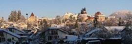
Peillonnex village seen from the RD12 road | ||
| ||
 Peillonnex | ||
|
Location within Auvergne-Rhône-Alpes region  Peillonnex | ||
| Coordinates: 46°07′56″N 6°22′37″E / 46.1322°N 6.3769°ECoordinates: 46°07′56″N 6°22′37″E / 46.1322°N 6.3769°E | ||
| Country | France | |
| Region | Auvergne-Rhône-Alpes | |
| Department | Haute-Savoie | |
| Arrondissement | Bonneville | |
| Canton | Canton of Bonneville | |
| Intercommunality | Communauté de communes des Quatre Rivières | |
| Government | ||
| • Mayor (2008–2014) | Jean-Jacques Duval | |
| Area1 | 6.40 km2 (2.47 sq mi) | |
| Population (1999)2 | 1,059 | |
| • Density | 170/km2 (430/sq mi) | |
| Time zone | CET (UTC+1) | |
| • Summer (DST) | CEST (UTC+2) | |
| INSEE/Postal code | 74209 / 74250 | |
| Elevation | 565–753 m (1,854–2,470 ft) | |
| Website | Peillonnex.com | |
|
1 French Land Register data, which excludes lakes, ponds, glaciers > 1 km² (0.386 sq mi or 247 acres) and river estuaries. 2 Population without double counting: residents of multiple communes (e.g., students and military personnel) only counted once. | ||

Peillonnex is a commune in the Haute-Savoie department in the Auvergne-Rhône-Alpes region in south-eastern France. The inhabitants are called Peillonnexois.
See also
References
| Wikimedia Commons has media related to Peillonnex. |
This article is issued from Wikipedia - version of the 10/28/2016. The text is available under the Creative Commons Attribution/Share Alike but additional terms may apply for the media files.